Kyūshū-Autobahn
| Kyūshū-Autobahn in Japan | |||||||||||||||||||||||||||||||||||||||||||||||||||||||||||||||||||||||||||||||||||||||||||||||||||||||||||||||||||||||||||||||||||||||||||||||||||||||||||||||||||||||||||||||||||||||||||||||||||||||||||||||||||||||||||||||||||||||||||||||||||||||||||||||||||||||||||||||||||||||||||||||||||||||||||||||||||||||||||||||||||||||||||||||||||||||||||||||||||
 | |||||||||||||||||||||||||||||||||||||||||||||||||||||||||||||||||||||||||||||||||||||||||||||||||||||||||||||||||||||||||||||||||||||||||||||||||||||||||||||||||||||||||||||||||||||||||||||||||||||||||||||||||||||||||||||||||||||||||||||||||||||||||||||||||||||||||||||||||||||||||||||||||||||||||||||||||||||||||||||||||||||||||||||||||||||||||||||||||||
| Karte | |||||||||||||||||||||||||||||||||||||||||||||||||||||||||||||||||||||||||||||||||||||||||||||||||||||||||||||||||||||||||||||||||||||||||||||||||||||||||||||||||||||||||||||||||||||||||||||||||||||||||||||||||||||||||||||||||||||||||||||||||||||||||||||||||||||||||||||||||||||||||||||||||||||||||||||||||||||||||||||||||||||||||||||||||||||||||||||||||||
 | |||||||||||||||||||||||||||||||||||||||||||||||||||||||||||||||||||||||||||||||||||||||||||||||||||||||||||||||||||||||||||||||||||||||||||||||||||||||||||||||||||||||||||||||||||||||||||||||||||||||||||||||||||||||||||||||||||||||||||||||||||||||||||||||||||||||||||||||||||||||||||||||||||||||||||||||||||||||||||||||||||||||||||||||||||||||||||||||||||
| Basisdaten | |||||||||||||||||||||||||||||||||||||||||||||||||||||||||||||||||||||||||||||||||||||||||||||||||||||||||||||||||||||||||||||||||||||||||||||||||||||||||||||||||||||||||||||||||||||||||||||||||||||||||||||||||||||||||||||||||||||||||||||||||||||||||||||||||||||||||||||||||||||||||||||||||||||||||||||||||||||||||||||||||||||||||||||||||||||||||||||||||||
| Betreiber: | NEXCO Nishi-Nihon | ||||||||||||||||||||||||||||||||||||||||||||||||||||||||||||||||||||||||||||||||||||||||||||||||||||||||||||||||||||||||||||||||||||||||||||||||||||||||||||||||||||||||||||||||||||||||||||||||||||||||||||||||||||||||||||||||||||||||||||||||||||||||||||||||||||||||||||||||||||||||||||||||||||||||||||||||||||||||||||||||||||||||||||||||||||||||||||||||||
| Gesamtlänge: | 346,4 km | ||||||||||||||||||||||||||||||||||||||||||||||||||||||||||||||||||||||||||||||||||||||||||||||||||||||||||||||||||||||||||||||||||||||||||||||||||||||||||||||||||||||||||||||||||||||||||||||||||||||||||||||||||||||||||||||||||||||||||||||||||||||||||||||||||||||||||||||||||||||||||||||||||||||||||||||||||||||||||||||||||||||||||||||||||||||||||||||||||
 | |||||||||||||||||||||||||||||||||||||||||||||||||||||||||||||||||||||||||||||||||||||||||||||||||||||||||||||||||||||||||||||||||||||||||||||||||||||||||||||||||||||||||||||||||||||||||||||||||||||||||||||||||||||||||||||||||||||||||||||||||||||||||||||||||||||||||||||||||||||||||||||||||||||||||||||||||||||||||||||||||||||||||||||||||||||||||||||||||||
| Kyūshū-Autobahn-Autobahn bei Kumamoto | |||||||||||||||||||||||||||||||||||||||||||||||||||||||||||||||||||||||||||||||||||||||||||||||||||||||||||||||||||||||||||||||||||||||||||||||||||||||||||||||||||||||||||||||||||||||||||||||||||||||||||||||||||||||||||||||||||||||||||||||||||||||||||||||||||||||||||||||||||||||||||||||||||||||||||||||||||||||||||||||||||||||||||||||||||||||||||||||||||
Straßenverlauf
| |||||||||||||||||||||||||||||||||||||||||||||||||||||||||||||||||||||||||||||||||||||||||||||||||||||||||||||||||||||||||||||||||||||||||||||||||||||||||||||||||||||||||||||||||||||||||||||||||||||||||||||||||||||||||||||||||||||||||||||||||||||||||||||||||||||||||||||||||||||||||||||||||||||||||||||||||||||||||||||||||||||||||||||||||||||||||||||||||||
Die Kyūshū-Autobahn (jap. 九州自動車道, Kyūshū Jidōshadō) ist eine verkehrstechnisch bedeutende Autobahn in Japan. Seit der Einführung eines Nummerierungssystems für japanische Autobahnen im Frühjahr 2017 trägt sie die Nummer E3. Sie durchquert die japanische Insel Kyūshū von Kitakyūshū bis Kagoshima. Ihr Verlauf folgt dabei im Wesentlichen dem der Nationalstraße 3.
Die 346,4 km lange Autobahn wird von der westjapanischen Autobahnbetreibergesellschaft Nishi-Nihon Kōsokudōro K.K. (engl. West Nippon Expressway Co., Ltd., NEXCO) betrieben und ist als „Nationale Hauptstrecke“ (Kokkandō, kurz für 国土開発幹線自動車道, kokudo kaihatsu kansen jidōshadō) klassifiziert.
Streckenbeschreibung
Kitakyūshū – Fukuoka
Die Kyūshū-Autobahn beginnt an der Anschlussstelle Moji in der Stadt Kitakyūshū und stellt die Fortsetzung der Kammon-Autobahn dar. Sie führt in ost-südöstlicher Richtung durch das restliche Stadtgebiet. In Kokura, dem zentralen Bezirk der Stadt Kitakyūshū, zweigt am Dreieck Kitakyūshū die Higashi-Kyūshū-Autobahn in Richtung Ōita ab. Anschließend folgen zwei lange Tunnel durch die Berge Fukuchiyama (der Hausberg von Kitakyūshū) und Kongōzan. Die Anschlussstelle Yahata stellt die letzte Ausfahrt auf dem Gebiet der Stadt Kitakyūshū dar. Die Kyūshū-Autobahn überquert dann den Fluss Onga, der die westliche Stadtgrenze bildet.
Danach durchquert die Kyūshū-Autobahn die Kohlereviere von Nōgata und Kurate. Anschließend wird der Verlauf von niedrigen, bewaldeten Bergen geprägt. Ab Koga führt sie primär in südliche Richtung. Zwischen den Anschlussstellen Fukuoka und Dazaifu führt sie an der Stadt Fukuoka vorbei. Beide Anschlussstellen stellen gleichzeitig auch Autobahndreiecke mit dem Netz der Stadtautobahn Fukuoka dar. An der Anschlussstelle Fukuoka zweigt die Route des Asian Highway 1 in Richtung Fährhafen Hakata ab. Ab der Anschlussstelle Dazaifu ist die Kyūshū-Autobahn sechsstreifig.
Fukuoka – Kurume
Südlich von Dazaifu überquert die Kyūshū-Autobahn eine niedrige Gebirgsschwelle, die die Ebene von Fukuoka von der Chikugo-Ebene trennt. Im Bereich dieses Abschnitts liegen mehrere historisch bedeutende Stätte, wie die Überreste des antiken Dazaifu, der Dazaifu-Temmangū-Schrein, der Mizuki-Schutzwall, und der Berg Tampaizan auf dem Gebiet der Stadt Chikushino.
Anschließend durchquert ein kurzes Stück der Kyūshū-Autobahn die Städte Kiyama und Tosu der Präfektur Saga. Kurz vor dem Kreuz Tosu tritt sie in die Chikugo-Ebene ein. An selbigem Kreuz geht in östlicher Richtung die Ōita-Autobahn, in westlicher Richtung die Nagasaki-Autobahn ab. Der gesamte in der Präfektur Saga liegende Abschnitt verläuft parallel zur Präfekturgrenze.
Nach dem Wiedereintritt in die Präfektur Fukuoka (Region Chikugo) überquert sie kurz vor der Anschlussstelle Kurume den längsten Fluss der Insel Kyūshū, den Chikugo. Ab der Anschlussstelle Kurume ist die Kyūshū-Autobahn für den Rest des Verlaufs vierstreifig
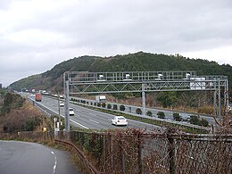
- Viadukt der Kyūshū-Autobahn vom Mizuki-Schutzwall aus gesehen
- Bei Kiyama
- Am Kreuz Tosu
Kurume – Kumamoto
Südlich von Kurume verlässt die Kyūshū-Autobahn die Chikugo-Ebene und verläuft durch die westlichen Ausläufer des Yame-Berglandes. An einigen Stellen hat man eine gute Aussicht auf die ländlich geprägten südlichen Abschnitte der Chikugo-Ebene zwischen Yanagawa und Ōmuta. Zwischen Ōmuta und Ueki wird das Terrain gebirgiger und steiler. Anschließend folgt die Ebene von Kumamoto.
- Bei Kurume
- Bei Hirokawa
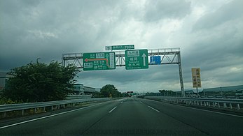
- Ausfahrt Nankan
- Bei Kumamoto, mit Schäden, die das Kumamoto-Erdbeben 2016 verursacht hat
Kumamoto – Yatsushiro
Die Kyūshū-Autobahn führt östlich an Kumamoto vorbei durch landwirtschaftlich geprägte gebiete der Kumamoto-Ebene. Das Relief ist flach bis sanft-hügelig. Nach der Anschlussstelle Mashiki zweigt die Chūō-Kyūshū-Autobahn ab. Am Dreieck Yatsushiro zweigt die Minami-Kyūshū-Autobahn ab, die als Parallele der Kyūshū-Autobahn weiter der Westküste Kyūshūs folgt. Die Trasse der Kyūshū-Autobahn führt in südöstlicher Richtung weiter durch das Higo-Gebirge.
- Bei Yatsushiro
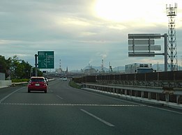
- Kurz vor dem Dreieck Yatsushiro
Yatsushiro – Ebino
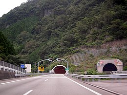
Unmittelbar südlich vom Dreieck Yatsushiro tritt die Kyūshū-Autobahn in das Higo-Gebirge ein. Dieser Abschnitt wird von insgesamt 23 Tunneln und mehreren Talbrücken zwischen diesen dominiert. Die einzige größere Ortschaft im Verlauf dieses Abschnitts ist die Stadt Hitoyoshi nach dem 22. der 23 Tunnel. Die längsten Tunnel dieses sehr gebirgigen Abschnitts sind der Higo-Tunnel (Nr. 15) und der Kakutō-Tunnel (Nr. 23). Im Verlauf dieses Abschnitts überquert die Kyūshū-Autobahn den Fluss Kumagawa mehrmals, der sich durch sein schmales Tal durch das Higo-Gebirge schlängelt.
Nach dam Kakutō-Tunnel, in dem die Präfekturgrenze Kumamoto-Miyazaki quert, endet das Higo-Gebirge und es beginnt die Ebino-Ebene. Ab hier ist die Landschaft von den Vulkanen des Kirishima-Berglandes geprägt. Die Stadt Ebino ist die einzige Gemeinde der Präfektur Miyazaki im Verlauf der Kyūshū-Autobahn. Am Autobahndreieck Ebino zweigt die Miyazaki-Autobahn in Richtung der Präfekturhauptstadt Miyazaki ab.
- Higo-Tunnel
- Bei Ebino
- Am Dreieck Ebino
Ebino – Kagoshima
Südlich von Ebino tritt die Kyūshū-Autobahn in die Präfektur Kagoshima ein. Dieser letzte Abschnitt ist geprägt von sanftem, niedrigem Bergland. Beim Dreieck Kajiki trifft die Kyūshū-Autobahn erneut auf die Higashi-Kyūshū-Autobahn, die dort ihr südliches Ende hat. Ab ungefähr hier beginnt die Satsuma-Halbinsel. Die Raststätte Sakurajima bietet einen schönen Panoramablick auf diesen Hausberg der Stadt Kagoshima.
Kurz vor Kagoshima wird das Terrain noch einmal schroffer, so dass die Kyūshū-Autobahn noch einmal durch zwei Tunnel führt. Wenige Kilometer vor dem Ende der Autobahn gibt es die Mautstelle Kagoshima-Kita.
Die Anschlussstelle Kagoshima stellt gleichzeitig sowohl das Ende der Kyūshū-Autobahn als auch der von der Westküste kommenden Minami-Kyūshū-Autobahn dar. Die Trasse verläuft dann als "Ibusuki Sky Line", einer größtenteils mautpflichtigen und zu Beginn autobahnähnlichen Schnellstraße, weiter bis nach Ibusuki am Südende der Satsuma-Halbinsel.
- Bei Aira
- Am Dreieck Kajiki
- Mautstelle Kagoshima-Kita
- Übergang von Ibusuki Sky Line in die Kyūshū-Autobahn
Anschlussstellen (Interchange)
Moji (1) – Shinmoji (1-1) – Kokura-Higashi (2) – Kokura-Minami (3) – Yahata (4) – Miyawaka (5) – Koga (6) – Fukuoka (7) – Dazaifu (8) – Chikushino (8-1) – Tosu (9) – Kurume (10) – Hirokawa (10-1) – Yame (11) – Miyama-Yanagawa (11-1) – Nankan (12) – Kikusui (13) – Ueki (14) – Kumamoto (15) – Mashiki-Kumamoto-Kūkō (15-1) – Mifune (16) – Matsuhashi (17) – Yatsushiro (18) – Hitoyoshi (19) – Ebino (20) – Kurino (22) – Yokogawa (23) – Mizobe-Kagoshima-Kūkō (24) – Kajiki (25) – Aira (26) – Satsuma-Yoshida (27) – Kagoshima-Kita (28) – Kagoshima (29)
Verlauf
- Präfektur Fukuoka
- Kitakyūshū – Nōgata – Miyawaka – Fukutsu – Koga – Fukuoka – Ōnojō – Dazaifu – Chikushino
- Präfektur Saga
- Präfektur Fukuoka
- Präfektur Kumamoto
- Präfektur Miyazaki
- Präfektur Kagoshima
Weblinks
- Betreibergesellschaft Nishi-Nihon Kōsokudōro K.K. (japanisch)
Auf dieser Seite verwendete Medien
(Autobahn)tunnel (Icon). Gezeichnet nach dem Vorbild schweizerischer Verkehrsschilder.
Nach links zeigendes schwarzes Dreieck ◀, U+25C0 aus dem Unicode-Block Geometrische Formen (25A0–25FF)
Nach rechts zeigendes schwarzes Dreieck ▶, U+25B6 aus dem Unicode-Block Geometrische Formen (25A0–25FF)
Wellenlinie als Gewässersymbol für die Formatvorlage Autobahn
Tankstellen-Piktogramm
Zeichen 314-50: Parken. Das Zeichen ist in den Größen 420x420, 600x600 sowie 840x840 mm erhältlich. Die Unternummer wurde im Jahr 2017 gestrichen (nun: Zeichen 314).
Zeichen 365-58: Toilette. Das Zeichen ist in den Größen 600x600 sowie 840x840 mm erhältlich und bekam im Jahr 2013 mit einem neuen Verkehrszeichenkatalog eine neue Nummer zugeordnet.
Zeichen 391 – Mautpflichtige Strecke, StVO 2003. Farblich korrekte Umsetzung der Originalvorlage mit dem digitalen RAL-Farbton „Verkehrsrot“. Im Verkehrsblatt, Heft 24, 1976, Seite 786, wird das Zeichen „Zollstelle“, aus dem Zeichen 391 abgeleitet wurde, in seinen Details abgebildet. Die Gesamtgröße beträgt in der Regel 600 x 600 mm, in Ausnahmefälle ist eine andere Größe möglich. Die Lichtkantenbreite beträgt 10 mm, der rote Rahmen ist 24 mm breit. Die Versalhöhe beträgt bei Zeichen 391 insgesamt 100 mm. Der Ausrundungshalbmesser am linken und rechten Ende des schwarzen Balkens beträgt 50 mm.
Autor/Urheber: ja:User:Sanjo, Lizenz: CC BY-SA 3.0
The Kyushu Expressway at border of Kagoshima City and Aira City, Kagoshima Prefecture, Japan.
Autor/Urheber: Project Kei, Lizenz: CC BY-SA 4.0
えびのジャンクションの案内標識
This is a diagram of Japanese National Route Sign. The glyphs of 国道 are the outline path from free font that is "NARAYAMA Maru Gothic" created by excl-zoo, based on "Wadalab Hosomaru Gothic". If you want to change the glyphs, you MUST check the license of substitute glyphs/fonts.
ja: 日本の国道標識。「国道」のグリフは「和田研細丸ゴシック」を種字とし excl-zoo が作成した「ならやま丸ゴシック」のアウトラインパスである。もし、「国道」のグリフを変更する場合は、変更に使用するフォントのライセンスを確認すること。特にグリフをアウトライン化して埋め込む場合、多くのフォントは商用利用に制限が存在する。
Zeichen 365-58: Toilette. Das Zeichen ist in den Größen 600x600 sowie 840x840 mm erhältlich und bekam im Jahr 2013 mit einem neuen Verkehrszeichenkatalog eine neue Nummer zugeordnet.
This is a diagram of Japanese National Route Sign. The glyphs of 国道 are the outline path from free font that is "NARAYAMA Maru Gothic" created by excl-zoo, based on "Wadalab Hosomaru Gothic". If you want to change the glyphs, you MUST check the license of substitute glyphs/fonts.
ja: 日本の国道標識。「国道」のグリフは「和田研細丸ゴシック」を種字とし excl-zoo が作成した「ならやま丸ゴシック」のアウトラインパスである。もし、「国道」のグリフを変更する場合は、変更に使用するフォントのライセンスを確認すること。特にグリフをアウトライン化して埋め込む場合、多くのフォントは商用利用に制限が存在する。
Schild des Asiatische Fernstraße 1
end of motorway symbol, coloured in green
This is a diagram of Minamikyushu (Nishimawari) Expwy route sign. This image's glyphs are the outline path from free font that is "GD-HighwayGothicJA(pumpCurry)". If you want to change the glyphs, you MUST check the license of substitute glyphs/fonts.
Autor/Urheber: Dake (Diskussion · Beiträge), Booyabazooka (Diskussion · Beiträge), Roulex 45 (Diskussion · Beiträge), and Doodledoo (Diskussion · Beiträge), Lizenz: CC BY-SA 2.5
Diese W3C-unbestimmte Vektorgrafik wurde mit Inkscape erstellt .
This is a diagram of Japanese National Route Sign. The glyphs of 国道 are the outline path from free font that is "NARAYAMA Maru Gothic" created by excl-zoo, based on "Wadalab Hosomaru Gothic". If you want to change the glyphs, you MUST check the license of substitute glyphs/fonts.
ja: 日本の国道標識。「国道」のグリフは「和田研細丸ゴシック」を種字とし excl-zoo が作成した「ならやま丸ゴシック」のアウトラインパスである。もし、「国道」のグリフを変更する場合は、変更に使用するフォントのライセンスを確認すること。特にグリフをアウトライン化して埋め込む場合、多くのフォントは商用利用に制限が存在する。
九州自動車道・広川IC付近(福岡県久留米市)
Autor/Urheber:
ButuCC
- Font "GD-HighwayGothicJA" - pumpCurry in Japan
This is a diagram of Naka-Kyushu Odan Road route sign.This image's glyphs are the outline path from free font that is "GD-HighwayGothicJA(pumpCurry)"(except for 「断」 glyphs.This is own image). If you want to change the glyphs, you MUST check the license of substitute glyphs/fonts.
This is a diagram of Higashikyūshū Expwy route sign. This image's glyphs are the outline path from free font that is "GD-HighwayGothicJA(pumpCurry)". If you want to change the glyphs, you MUST check the license of substitute glyphs/fonts.
This is a diagram of Kyushu Chuo Expwy route sign.This image's glyphs are the outline path from free font that is "VL Gothic"(Amended,Substitute of the Hiragino).
Autor/Urheber: hyolee2, Lizenz: CC BY-SA 3.0
熊本地震で路面に亀裂が入った九州自動車道嘉島JCT-益城熊本空港IC
This is a diagram of Miyazaki Expwy route sign. This image's glyphs are the outline path from free font that is "GD-HighwayGothicJA(pumpCurry)". If you want to change the glyphs, you MUST check the license of substitute glyphs/fonts.
This is a diagram of Ōita Expwy route sign. This image's glyphs are the outline path from free font that is "GD-HighwayGothicJA(pumpCurry)". If you want to change the glyphs, you MUST check the license of substitute glyphs/fonts.
This is a diagram of Kyūshū Expwy route sign. This image's glyphs are the outline path from free font that is "GD-HighwayGothicJA(pumpCurry)". If you want to change the glyphs, you MUST check the license of substitute glyphs/fonts.
九州自動車道・南関IC下り線方向
This is a diagram of Japanese National Route Sign. The glyphs of 国道 are the outline path from free font that is "NARAYAMA Maru Gothic" created by excl-zoo, based on "Wadalab Hosomaru Gothic". If you want to change the glyphs, you MUST check the license of substitute glyphs/fonts.
ja: 日本の国道標識。「国道」のグリフは「和田研細丸ゴシック」を種字とし excl-zoo が作成した「ならやま丸ゴシック」のアウトラインパスである。もし、「国道」のグリフを変更する場合は、変更に使用するフォントのライセンスを確認すること。特にグリフをアウトライン化して埋め込む場合、多くのフォントは商用利用に制限が存在する。
Autor/Urheber: そらみみ (Soramimi), Lizenz: CC BY-SA 4.0
水城跡より望む九州自動車道
Autor/Urheber: ja:User:Sanjo, Lizenz: CC BY-SA 3.0
Kagoshima Interchange, the end point of the Ibusuki Skyline and the Kyushu Expressway in Kagoshima City, Japan
This is a diagram of Japanese National Route Sign. The glyphs of 国道 are the outline path from free font that is "NARAYAMA Maru Gothic" created by excl-zoo, based on "Wadalab Hosomaru Gothic". If you want to change the glyphs, you MUST check the license of substitute glyphs/fonts.
ja: 日本の国道標識。「国道」のグリフは「和田研細丸ゴシック」を種字とし excl-zoo が作成した「ならやま丸ゴシック」のアウトラインパスである。もし、「国道」のグリフを変更する場合は、変更に使用するフォントのライセンスを確認すること。特にグリフをアウトライン化して埋め込む場合、多くのフォントは商用利用に制限が存在する。
Autor/Urheber: Project Kei, Lizenz: CC BY-SA 4.0
加治木ジャンクションの案内標識
This is a diagram of Japanese National Route Sign. The glyphs of 国道 are the outline path from free font that is "NARAYAMA Maru Gothic" created by excl-zoo, based on "Wadalab Hosomaru Gothic". If you want to change the glyphs, you MUST check the license of substitute glyphs/fonts.
ja: 日本の国道標識。「国道」のグリフは「和田研細丸ゴシック」を種字とし excl-zoo が作成した「ならやま丸ゴシック」のアウトラインパスである。もし、「国道」のグリフを変更する場合は、変更に使用するフォントのライセンスを確認すること。特にグリフをアウトライン化して埋め込む場合、多くのフォントは商用利用に制限が存在する。
This is a diagram of Kanmonkyo_Bridge route sign. This image's glyphs are the outline path from free font that is "GD-HighwayGothicJA(pumpCurry)". If you want to change the glyphs, you MUST check the license of substitute glyphs/fonts.
Motorway Exit Icon in green for left-hand driving areas
This is a diagram of Japanese National Route Sign. The glyphs of 国道 are the outline path from free font that is "NARAYAMA Maru Gothic" created by excl-zoo, based on "Wadalab Hosomaru Gothic". If you want to change the glyphs, you MUST check the license of substitute glyphs/fonts.
ja: 日本の国道標識。「国道」のグリフは「和田研細丸ゴシック」を種字とし excl-zoo が作成した「ならやま丸ゴシック」のアウトラインパスである。もし、「国道」のグリフを変更する場合は、変更に使用するフォントのライセンスを確認すること。特にグリフをアウトライン化して埋め込む場合、多くのフォントは商用利用に制限が存在する。
Autor/Urheber: Ray_go, Lizenz: CC BY-SA 3.0
Kakutou Basin and Kirishima Mountains in Kyūshū, Japan. Taken from Kirino-ohashi Bridge on Route 221.
九州自動車道・福岡県久留米市高良内町付近の急カーブ地点(福岡県久留米市)
Zeichen 314-50: Parken. Das Zeichen ist in den Größen 420x420, 600x600 sowie 840x840 mm erhältlich. Die Unternummer wurde im Jahr 2017 gestrichen (nun: Zeichen 314).
This is a diagram of Japanese National Route Sign. The glyphs of 国道 are the outline path from free font that is "NARAYAMA Maru Gothic" created by excl-zoo, based on "Wadalab Hosomaru Gothic". If you want to change the glyphs, you MUST check the license of substitute glyphs/fonts.
ja: 日本の国道標識。「国道」のグリフは「和田研細丸ゴシック」を種字とし excl-zoo が作成した「ならやま丸ゴシック」のアウトラインパスである。もし、「国道」のグリフを変更する場合は、変更に使用するフォントのライセンスを確認すること。特にグリフをアウトライン化して埋め込む場合、多くのフォントは商用利用に制限が存在する。
Autor/Urheber: Sanjo, Lizenz: CC BY-SA 4.0
The Kyushu Expressway at Yatsushiro City, Kumamoto Prefecture, Japan
This is a diagram of Nagasaki Expwy route sign. This image's glyphs are the outline path from free font that is "GD-HighwayGothicJA(pumpCurry)". If you want to change the glyphs, you MUST check the license of substitute glyphs/fonts.
This is a diagram of Japanese National Route Sign. The glyphs of 国道 are the outline path from free font that is "NARAYAMA Maru Gothic" created by excl-zoo, based on "Wadalab Hosomaru Gothic". If you want to change the glyphs, you MUST check the license of substitute glyphs/fonts.
ja: 日本の国道標識。「国道」のグリフは「和田研細丸ゴシック」を種字とし excl-zoo が作成した「ならやま丸ゴシック」のアウトラインパスである。もし、「国道」のグリフを変更する場合は、変更に使用するフォントのライセンスを確認すること。特にグリフをアウトライン化して埋め込む場合、多くのフォントは商用利用に制限が存在する。
Autor/Urheber: Sanjo, Lizenz: CC BY-SA 3.0
Kyūshū Expressway at Kumamoto City, Japan.
Autor/Urheber: Project Kei, Lizenz: CC BY-SA 4.0
八代ジャンクションの案内標識


