Kingsbury County
 Kingsbury County Courthouse in De Smet | |
| Verwaltung | |
|---|---|
| US-Bundesstaat: | South Dakota |
| Verwaltungssitz: | De Smet |
| Gründung: | 1873 |
| Demographie | |
| Einwohner: | 5.187 (Stand: 2020) |
| Bevölkerungsdichte: | 2,39 Einwohner/km2 |
| Geographie | |
| Fläche gesamt: | 2237 km² |
| Wasserfläche: | 66 km² |
| Karte | |
Kingsbury County[1] ist ein County im Bundesstaat South Dakota der Vereinigten Staaten. Das U.S. Census Bureau hat bei der Volkszählung 2020 eine Einwohnerzahl von 5.187[2] ermittelt.
Geographie
Das County hat eine Fläche von 2237 Quadratkilometer. Davon sind 66 Quadratkilometer (2,93 Prozent) Wasserflächen. Es grenzt im Uhrzeigersinn an die Countys: Hamlin County, Brookings County, Lake County, Beadle County und Clark County
Geschichte
Das County wurde am 8. Januar 1873 gegründet und die Verwaltungsorganisation am 18. Februar 1880 abgeschlossen. Es wurde nach den Brüdern George Washington (1837–1925) und T. A. Kingsbury benannt. George Washington war Unternehmensgründer, Autor und Abgeordneter in der gesetzgebenden Versammlung des Dakota-Territoriums, der auch sein Bruder angehörte.[3]
20 Bauwerke und Stätten des Countys sind im National Register of Historic Places (NRHP) eingetragen (Stand 2. August 2018).[4]
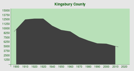
Bevölkerungsentwicklung
| 1900 | 1910 | 1920 | 1930 | 1940 | 1950 | 1960 | 1970 | 1980 | 1990 | 2000 | 2010 | 2020 |
|---|---|---|---|---|---|---|---|---|---|---|---|---|
| 9.866 | 12.560 | 12.802 | 12.805 | 10.831 | 9.962 | 9.227 | 7.657 | 6.679 | 5.925 | 5.815 | 5148 | 5187 |
Städte und Gemeinden
Weblinks
Einzelnachweise
- ↑ Kingsbury County. In: Geographic Names Information System. United States Geological Survey, United States Department of the Interior (englisch).. Abgerufen am 22. Februar 2011
- ↑ Explore Census Data Total Population in Kingsbury County, South Dakota. Abgerufen am 17. März 2023.
- ↑ Charles Curry Aiken, Joseph Nathan Kane: The American Counties: Origins of County Names, Dates of Creation, Area, and Population Data, 1950–2010. 6. Auflage. Scarecrow Press, Lanham 2013, ISBN 978-0-8108-8762-6, S. 164.
- ↑ Suchmaske Datenbank im National Register Information System. National Park Service, abgerufen am 2. August 2018.
- ↑ 1900–1990 Auszug aus Census.gov. Abgerufen am 20. März 2015
Koordinaten: 44° 22′ N, 97° 29′ W
Auf dieser Seite verwendete Medien
The Kingsbury County Courthouse, located along Highway 25 in De Smet, South Dakota, United States. Built in 1898, it is listed on the National Register of Historic Places.
Autor/Urheber: Majo statt Senf, Lizenz: CC BY-SA 4.0
Bevölkerungsentwicklung von Kingsbury County
This is a locator map showing Kingsbury County in South Dakota. For more information, see Commons:United States county locator maps.


