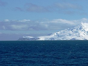
Kap James
| Kap James | ||
 Kap James (links) | ||
| Geographische Lage | ||
| Koordinaten | 63° 5′ S, 62° 42′ W | |
| Lage | Smith Island, Südliche Shetlandinseln | |
| Gewässer | Drakestraße | |
| Gewässer 2 | Bransfieldstraße | |
 Karte von Smith Island mit Kap James (unten) | ||
Kap James ist ein Kap, welches die Südspitze von Smith Island im Archipel der Südlichen Shetlandinseln bildet.
Der Name des Kaps ist in Landkarten enthalten, die auf den Arbeiten des britischen Polarreisenden Henry Foster zwischen 1828 und 1831 basieren. Foster benannte es nach dem britischen Seefahrer James Weddell (1787–1834). In einer Entfernung von drei bis fünf Kilometer westlich des Kaps liegen die Van Rocks.
Weblinks
- Cape James im Geographic Names Information System des United States Geological Survey (englisch)
- Cape James auf geographic.org (englisch)
Auf dieser Seite verwendete Medien
Autor/Urheber: Apcbg, Lizenz: CC BY-SA 4.0
L.L. Ivanov. Antarctica: Smith Island. Scale 1:100000 topographic map. Manfred Wörner Foundation, 2017. Revised and updated version of the first topographic map of Smith Island, fragment of the author’s 2010 map of Livingston Island and Greenwich, Robert, Snow and Smith Islands.
Autor/Urheber: NordNordWest, Lizenz: CC BY-SA 3.0
Positionskarte der Südlichen Shetlandinseln
Cape James, Smith Island, South Shetland Islands. Derivative work, fragment of the photo of Smith Island, Antarctica, taken from deck of R/V Lawrence M. Gould by Cfrohlich, Cliff Frohlich, Univ. Texas Austin


