Kap Herlacher
| Kap Herlacher | ||
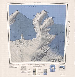
 Topografische Karte der Martin-Halbinsel mit Kap Herlacher (oben) | ||
| Geographische Lage | ||
| Koordinaten | 73° 52′ S, 114° 12′ W | |
| Lage | Marie-Byrd-Land, Westantarktika | |
| Küste | Bakutis-Küste | |
| Gewässer | Amundsen-See | |
| Gewässer 2 | Glade Bay | |
Kap Herlacher ist ein wuchtiges und eisbedecktes Kap an der Bakutis-Küste des westantarktischen Marie-Byrd-Lands. Es stellt das nördliche Ende der Martin-Halbinsel dar.
Eine erste Kartierung erfolgte anhand von Luftaufnahmen, die im Januar 1947 im Rahmen der Operation Highjump (1946–1947) entstanden. Das Advisory Committee on Antarctic Names benannte das Kap nach Carl John Herlacher (1895–1975), leitender Antarktiskartograf des United States Hydrographic Office im Jahr 1937.
Weblinks
- Cape Herlacher im Geographic Names Information System des United States Geological Survey (englisch)
- Cape Herlacher auf geographic.org (englisch)
Auf dieser Seite verwendete Medien
Autor/Urheber: Alexrk2, Lizenz: CC BY-SA 3.0
Physische Positionskarte Antarktis, Mittabstandstreue Azimutalprojektion
1:250,000-scale topographic reconnaissance map of the Martin Peninsula area from 112°30'-117°W to 73°45'-75°S in Antarctica, including the eastern parts of the Getz Ice Shelf and the western parts of Dotson Ice Shelf. Mapped, edited and published by the U.S. Geological Survey in cooperation with the National Science Foundation.


