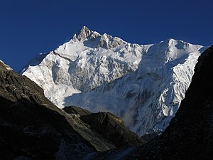
Kangchendzönga-Südgipfel
| Kangchendzönga-Südgipfel | ||
|---|---|---|
Kangchendzönga-Südgipfel und Südwand vom Goecha-La | ||
| Höhe | 8476 m | |
| Lage | Taplejung (Nepal), North Sikkim (Indien) | |
| Gebirge | Kangchendzönga Himal (Himalaya) | |
| Dominanz | 1,44 km → Kangchendzönga | |
| Schartenhöhe | 76 m ↓ (8400 m) | |
| Koordinaten | 27° 41′ 30″ N, 88° 9′ 15″ O | |
| ||
| Erstbesteigung | 19. Mai 1978 durch Eugeniusz Chrobak und Wojciech Wróż | |
Der Kangchendzönga-Südgipfel (englisch Kanchenjunga South) ist ein 8476 m hoher Nebengipfel des Kangchendzönga, des im Himalaya gelegenen und mit 8586 m dritthöchsten Berges der Erde.
Der Gipfel befindet sich an der nepalesisch-indischen Grenze. Ein Berggrat führt nach Norden über den Mittelgipfel zum Hauptgipfel des Kangchendzönga. Nach Osten zweigt ein Berggrat zum Zemu Kang (7730 m) ab. Nach Süden führt der Bergkamm weiter über Hogsback Peak (7379 m) und Talung (7349 m) zum Kabru.
Die Erstbesteigung des Gipfels erfolgte erst im Jahr 1978 – 23 Jahre nach dem ersten gelungenen Aufstieg zum Hauptgipfel – durch die Polen Eugeniusz Chrobak und Wojciech Wróż[1]. 1989 wurde der Berg erstmals ohne Flaschensauerstoff bestiegen.
Weblinks
- Kangchendzönga-Südgipfel auf Peakbagger.com (englisch)
Einzelnachweise
Auf dieser Seite verwendete Medien
(c) Karte: NordNordWest, Lizenz: Creative Commons by-sa-3.0 de
Positionskarte von Provinz Nr. 1, Nepal
Autor/Urheber: Ashinpt at enwiki, Lizenz: CC-BY-SA-3.0
Picture of Kangchenjunga taken by author from Goecha La pass, 4940m, Sikkim. The peak in the image is actually the South peak of Kangchenjunga, which is about 400 ft lower than the main peak. You can also see the West peak of Kangchenjunga (Yalung Kang) as the round peak slightly to the left of the South Ridge (the ridge going left from the South peak).


