Jones-Schelfeis
Koordinaten: 67° 31′ S, 67° 1′ W
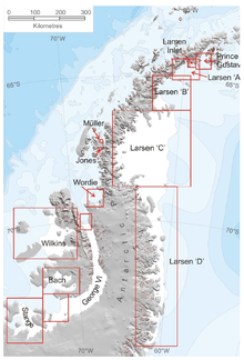
Das Jones Schelfeis war ein kleines antarktisches Schelfeis, das bis 2003 den Jones-Kanal zwischen der Arrowsmith-Halbinsel und der Blaiklock-Insel ausfüllte. Es hatte eine Fläche von knapp 30 km², war zwischen 150 m und 250 m dick und wurde in erster Linie vom Heim-Gletscher gespeist.[1] Nach einer Phase der relativen Stabilität begann es ab 1970 sich zurückzuziehen und löste sich 2003 vollständig auf.[2]
Einzelnachweise
- ↑ A. J. Cook and D. G. Vaughan, Overview of areal changes of the ice shelves on the Antarctic Peninsula over the past 50 years, The Cryosphere, 4, 77–98, 2010 www.the-cryosphere.net/4/77/2010/
- ↑ Fox, Adrian & Vaughan, David. (2005). The retreat of Jones Ice Shelf, Antarctic Peninsula. Journal of Glaciology. 51. 555-560. doi:10.3189/172756505781829043.
Weblinks
- Jones Ice Shelf. In: Geographic Names Information System. United States Geological Survey, United States Department of the Interior, archiviert vom (englisch).
- Jones Ice Shelf auf geographic.org
Auf dieser Seite verwendete Medien
Autor/Urheber: Alexrk2, Lizenz: CC BY-SA 3.0
Physische Positionskarte Antarktis, Mittabstandstreue Azimutalprojektion
(c) A. J. Cook and D. G. Vaughan, CC BY 3.0
The ice shelves of the Antarctic peninsula.


