Johnson County (Illinois)
 Johnson County Courthouse | |
| Verwaltung | |
|---|---|
| US-Bundesstaat: | Illinois |
| Verwaltungssitz: | Vienna |
| Adresse des Verwaltungssitzes: | Johnson County Courthouse 400 Court Sq. P.O. Box 96 Vienna, IL 62995 |
| Gründung: | 14. September 1812 |
| Gebildet aus: | Randolph County |
| Vorwahl: | 001 618 |
| Demographie | |
| Einwohner: | 13.308 (Stand: 2020) |
| Bevölkerungsdichte: | 14,9 Einwohner/km2 |
| Geographie | |
| Fläche gesamt: | 904 km² |
| Wasserfläche: | 11 km² |
| Karte | |
 | |
Das Johnson County[1] ist ein County im US-amerikanischen Bundesstaat Illinois. Im Jahr 2010 hatte das County 12.582 Einwohner und eine Bevölkerungsdichte von 14,1 Einwohnern pro Quadratkilometer.[2] Der Verwaltungssitz (County Seat) ist Vienna.[3]
Geografie
Das County liegt im Süden von Illinois und hat eine Fläche von 904 Quadratkilometern, wovon elf Quadratkilometer Wasserfläche sind. An das Johnson County grenzen folgende Nachbarcountys:
| Williamson County | Saline County | |
| Union County | .svg) | Pope County |
| Pulaski County | Massac County |
Geschichte

Das Johnson County wurde am 14. September 1812 aus Teilen des Randolph County gebildet, gehört aber zu den 15 Original-Countys des Territoriums Illinois.
Benannt wurde es nach Richard M. Johnson (1780 oder 1781–1850), einem Offizier im Krieg von 1812, US-Senator von Kentucky (1819–1829) und neunten Vizepräsidenten der USA (1837–1841).
Der erste Sitz der Countyverwaltung war im Haus von John Bradshaw (1813–1814), danach wurde es Elvira (1814–1818), bevor es 1818 Vienna wurde.
Territoriale Entwicklung

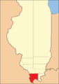
Das Johnson County von seiner Gründung im Jahr 1812 bis 1816
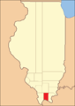
1816 bis 1818
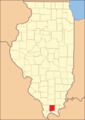
1818 bis 1843
1843 bis heute
Demografische Daten
| Bevölkerungsentwicklung | |||
|---|---|---|---|
| Census | Einwohner | ± rel. | |
| 1820 | 843 | — | |
| 1830 | 1596 | 89,3 % | |
| 1840 | 3626 | 127,2 % | |
| 1850 | 4114 | 13,5 % | |
| 1860 | 9342 | 127,1 % | |
| 1870 | 11.248 | 20,4 % | |
| 1880 | 13.078 | 16,3 % | |
| 1890 | 15.013 | 14,8 % | |
| 1900 | 15.667 | 4,4 % | |
| 1910 | 14.331 | −8,5 % | |
| 1920 | 12.022 | −16,1 % | |
| 1930 | 10.203 | −15,1 % | |
| 1940 | 10.727 | 5,1 % | |
| 1950 | 8729 | −18,6 % | |
| 1960 | 6928 | −20,6 % | |
| 1970 | 7550 | 9 % | |
| 1980 | 9624 | 27,5 % | |
| 1990 | 11.347 | 17,9 % | |
| 2000 | 12.878 | 13,5 % | |
| 2010 | 12.582 | −2,3 % | |
| 2020 | 13.308 | 5,8 % | |
| Vor 1900[4] 1900–1990[5] 2000[3] 2010[2] | |||
Nach der Volkszählung im Jahr 2010 lebten im Johnson County 12.582 Menschen in 4396 Haushalten. Die Bevölkerungsdichte betrug 14,1 Einwohner pro Quadratkilometer. In den 4396 Haushalten lebten statistisch je 2,24 Personen.
Ethnisch betrachtet setzte sich die Bevölkerung zusammen aus 89,9 Prozent Weißen, 8,5 Prozent Afroamerikanern, 0,4 Prozent amerikanischen Ureinwohnern, 0,2 Prozent Asiaten sowie aus anderen ethnischen Gruppen; 1,0 Prozent stammten von zwei oder mehr Ethnien ab. Unabhängig von der ethnischen Zugehörigkeit waren 3,1 Prozent der Bevölkerung spanischer oder lateinamerikanischer Abstammung.
18,8 Prozent der Bevölkerung waren unter 18 Jahre alt, 63,6 Prozent waren zwischen 18 und 64 und 17,6 Prozent waren 65 Jahre oder älter. 44,2 Prozent der Bevölkerung war weiblich.
Das jährliche Durchschnittseinkommen eines Haushalts lag bei 41.619 USD. Das Pro-Kopf-Einkommen betrug 16.402 USD. 13,6 Prozent der Einwohner lebten unterhalb der Armutsgrenze.[2]
Ortschaften im Johnson County
- Vienna
|
|
|
|
|
|
Gliederung
Das Johnson County ist in 17 Bezirke (precincts) eingeteilt[6]:
| Bezirk | Einwohner (2010) | FIPS |
|---|---|---|
| Belknap precinct | 245 | 17-90346 |
| Bloomfield precinct | 922 | 17-90450 |
| Burnside precinct | 516 | 17-90558 |
| Cache precinct | 593 | 17-90594 |
| Elvira precinct | 820 | 17-91188 |
| Goreville No. 1 precinct | 1500 | 17-91440 |
| Goreville No. 2 precinct | 528 | 17-91458 |
| Grantsburg No. 1 precinct | 1915 | 17-91512 |
| Grantsburg No. 2 precinct | 296 | 17-91530 |
| Lake No. 1 precinct | 885 | 17-91840 |
| Lake No. 2 precinct | 457 | 17-91842 |
| Ozark precinct | 545 | 17-92340 |
| Simpson precinct | 582 | 17-93168 |
| Tunnel Hill precinct | 619 | 17-93456 |
| Vienna No. 1 precinct | 515 | 17-93528 |
| Vienna No. 2 precinct | 937 | 17-93546 |
| Vienna No. 3 precinct | 707 | 17-93552 |
Siehe auch
Einzelnachweise
- ↑ GNIS-ID: 424245. Abgerufen am 22. Februar 2011 (englisch).
- ↑ a b c U.S. Census Buero, State & County QuickFacts - Johnson County, IL (Memento des Originals vom 12. Juli 2011 auf WebCite) Info: Der Archivlink wurde automatisch eingesetzt und noch nicht geprüft. Bitte prüfe Original- und Archivlink gemäß Anleitung und entferne dann diesen Hinweis. Abgerufen am 11. Dezember 2012
- ↑ a b National Association of Counties Abgerufen am 11. Dezember 2012
- ↑ U.S. Census Bureau - Census of Population and Housing Abgerufen am 15. März 2011
- ↑ Auszug aus Census.gov Abgerufen am 15. Februar 2011
- ↑ Missouri Census Data Center - Illinois (Seite nicht mehr abrufbar, Suche in Webarchiven) Info: Der Link wurde automatisch als defekt markiert. Bitte prüfe den Link gemäß Anleitung und entferne dann diesen Hinweis. Abgerufen am 1. August 2012
Weblinks
Liste der Countys in Illinois
Adams | Alexander | Bond | Boone | Brown | Bureau | Calhoun | Carroll | Cass | Champaign | Christian | Clark | Clay | Clinton | Coles | Cook | Crawford | Cumberland | DeKalb | DeWitt | Douglas | DuPage | Edgar | Edwards | Effingham | Fayette | Ford | Franklin | Fulton | Gallatin | Greene | Grundy | Hamilton | Hancock | Hardin | Henderson | Henry | Iroquois | Jackson | Jasper | Jefferson | Jersey | Jo Daviess | Johnson | Kane | Kankakee | Kendall | Knox | LaSalle | Lake | Lawrence | Lee | Livingston | Logan | Macon | Macoupin | Madison | Marion | Marshall | Mason | Massac | McDonough | McHenry | McLean | Menard | Mercer | Monroe | Montgomery | Morgan | Moultrie | Ogle | Peoria | Perry | Piatt | Pike | Pope | Pulaski | Putnam | Randolph | Richland | Rock Island | Saline | Sangamon | Schuyler | Scott | Shelby | St. Clair | Stark | Stephenson | Tazewell | Union | Vermilion | Wabash | Warren | Washington | Wayne | White | Whiteside | Will | Williamson | Winnebago | Woodford
Koordinaten: 37° 28′ N, 88° 52′ W
Auf dieser Seite verwendete Medien
Southern and eastern sides of the Johnson County Courthouse, located on Courthouse Square in Vienna, Illinois, United States. Built in 1868, it is listed on the National Register of Historic Places.
This is a locator map showing Johnson County in Illinois. For more information, see Commons:United States county locator maps.


Locator Map of Johnson County, Illinois, 1818-1843.
Based on: Illinois Secretary of State. Origin and Evolution of Illinois Counties. March 2010. p. 36. http://www.cyberdriveillinois.com/publications/pdf_publications/ipub15.pdf
Locator Map of Johnson County, Illinois, 1843.
Based on: Illinois Secretary of State. Origin and Evolution of Illinois Counties. March 2010. p. 58. http://www.cyberdriveillinois.com/publications/pdf_publications/ipub15.pdf
Locator Map of Johnson County, Illinois, 1812-1816.
Based on: Illinois Secretary of State. Origin and Evolution of Illinois Counties. March 2010. p. 26. http://www.cyberdriveillinois.com/publications/pdf_publications/ipub15.pdf
Locator Map of Johnson County, Illinois, 1816-1818.
Based on: Illinois Secretary of State. Origin and Evolution of Illinois Counties. March 2010. p. 32. http://www.cyberdriveillinois.com/publications/pdf_publications/ipub15.pdf