Jeddito
| Jeddito | |
|---|---|
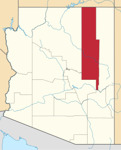
Lage im County und in Arizona | |
| Basisdaten | |
| Staat: | Vereinigte Staaten |
| Bundesstaat: | Arizona |
| County: | Navajo County |
| Koordinaten: | 35° 46′ N, 110° 8′ W |
| Zeitzone: | Mountain Standard Time (UTC−7) |
| Einwohner: | 346 (Stand: 2020) |
| Haushalte: | 74 (Stand: 2020) |
| Fläche: | 14,5 km2 (ca. 6 mi²) davon 14,4 km2 (ca. 6 mi²) Land |
| Bevölkerungsdichte: | 24 Einwohner je km2 |
| Höhe: | 1932 m |
| Postleitzahl: | 86034 |
| Vorwahl: | +1 928 |
| FIPS: | 04-36150 |
| GNIS-ID: | 0024262 |
| Website: | jeddito.navajochapters.org |
Jeddito (Navajo: Jádító) ist ein Census-designated place im Navajo County im Nordwesten des US-Bundesstaates Arizona an der Grenze zum Apache County. Das U.S. Census Bureau hat bei der Volkszählung 2020 eine Einwohnerzahl von 346[1] auf einer Fläche von 14,1 km² ermittelt.
Jeddito liegt in der Navajo-Nation-Reservation. Er wird vom Arizona State Route 264 tangiert.
Einzelnachweise
- ↑ Explore Census Data Jeddito CDP, Arizona. Abgerufen am 22. Oktober 2022.
Auf dieser Seite verwendete Medien
Autor/Urheber: Arkyan, Lizenz: CC BY-SA 3.0
This map shows the incorporated and unincorporated areas and Indian reservations in Jeddito County, Arizona, highlighting Holbrook in red. I created it in Inkscape using data from the US Census Bureau.


