James Hall (Paläontologe)

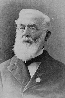
James Hall (* 12. September 1811 in Hingham, Massachusetts; † 7. August 1898 in Bethlehem, New Hampshire) war ein US-amerikanischer Paläontologe und Geologe.
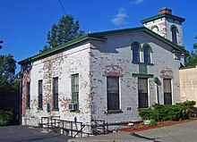
Hall studierte unter anderem Geologie bei Amos Eaton und Ebenezer Emmons am Rensselaer Polytechnic Institute mit dem Master-Abschluss 1833 und lehrte dann Chemie und Geologie am Rensselaer Polytec. 1836 war er Teil eines mehrjährigen Projekts der geologischen Landesaufnahme des Staates New York, zunächst als Assistent von Emmons. Dabei wurde die Stratigraphie der geologischen Schichten festgelegt und benannt. Nach Ende der Arbeit 1841 wurde er erster Staats-Paläontologe von New York. Der Endreport seines Distrikts (die Landesaufnahme war in vier Distrikte aufgeteilt), des vierten im westlichen Teil von New York, erschien 1843. Hall gründete ein Labor in Albany, das heute als James Hall Office bekannt ist und unter Denkmalschutz steht. Dort wurden viele bekannte Geologen und Paläontologen ausgebildet wie Charles Walcott und Charles Emerson Beecher, die seine Assistenten waren. 1866 wurde er Direktor des Museum of Natural History von New York in Albany. 1893 wurde er Staatsgeologe von New York. Er liegt in Albany begraben.
Hall entdeckte unter anderem, dass die Stromatolithen in den Petrified Sea Gardens in Saratoga Springs organischen Ursprungs sind.
Neben seiner Arbeit in New York erkundete er auch den Rest der USA. 1850 nahm er an der geologischen Aufnahme von Nord-Michigan und Wisconsin teil, wobei er die ersten fossilen Riffe in den USA entdeckte. Von 1855 bis 1858 war er Staatsgeologe von Iowa und von 1857 bis 1860 von Wisconsin.
Er war Gründungsmitglied der National Academy of Sciences und der erste Präsident der Geological Society of America. Er gehörte 1875 zu den Gründern des Internationalen Geologenkongresses und war bei deren Sitzung in Paris, Bologna und Berlin und nahm noch an der Sitzung 1896 in Sankt Petersburg (und einer Exkursion in den Ural) teil.
1848 wurde Hall in die American Academy of Arts and Sciences gewählt. Ebenfalls 1848 wurde er auswärtiges Mitglied der Geological Society of London, deren Wollaston Medal er 1858 erhielt, und 1884 der französischen Académie des sciences. Seit 1854 war er Mitglied der American Philosophical Society.[1] Im Jahr 1879 wurde Hall zum Mitglied der Leopoldina,[2] 1885 zum korrespondierenden Mitglied der Göttinger Akademie der Wissenschaften[3] und 1886 zum Mitglied der Académie royale des Sciences, des Lettres et des Beaux-Arts de Belgique[4] gewählt. 1895 wurde er Ehrenmitglied der Russischen Akademie der Wissenschaften in Sankt Petersburg.
Sein Assistent und Nachfolger als Staatspaläontologe war John Mason Clarke.
Er ist nicht mit dem schottischen Geologen James Hall zu verwechseln.
Schriften

Hall schrieb über 30 Bücher und über 200 wissenschaftliche Abhandlungen. Darunter:
- Geology of New York IV, 1843
- Paleontology of New York, 13 Bände, 1847–1894
- Geology of Iowa, 2 Bände, 1858, 1859
- United States and Mexican Boundary Survey, 1857
Weblinks
Einzelnachweise
- ↑ Member History: James Hall. American Philosophical Society, abgerufen am 19. September 2018.
- ↑ Mitgliedseintrag von James Hall bei der Deutschen Akademie der Naturforscher Leopoldina, abgerufen am 7. Juli 2022.
- ↑ Holger Krahnke: Die Mitglieder der Akademie der Wissenschaften zu Göttingen 1751–2001 (= Abhandlungen der Akademie der Wissenschaften zu Göttingen, Philologisch-Historische Klasse. Folge 3, Bd. 246 = Abhandlungen der Akademie der Wissenschaften in Göttingen, Mathematisch-Physikalische Klasse. Folge 3, Bd. 50). Vandenhoeck & Ruprecht, Göttingen 2001, ISBN 3-525-82516-1, S. 101.
- ↑ Académicien décédé: James Hall. Académie royale des Sciences, des Lettres et des Beaux-Arts de Belgique, abgerufen am 22. September 2023 (französisch).
| Personendaten | |
|---|---|
| NAME | Hall, James |
| KURZBESCHREIBUNG | US-amerikanischer Geologe und Paläontologe |
| GEBURTSDATUM | 12. September 1811 |
| GEBURTSORT | Hingham, Massachusetts |
| STERBEDATUM | 7. August 1898 |
| STERBEORT | Bethlehem, New Hampshire |
Auf dieser Seite verwendete Medien
James Hall (September 12, 1811–August 7, 1898) was an American geologist and paleontologist. He was a noted authority on stratigraphy and had an influential role in the development of American paleontology.
(c) English Wikipedia Benutzer Daniel Case, CC BY-SA 3.0
Office of geologist and paleontologist James Hall in Lincoln Park, Albany, NY, USA
Drawn by Thomas Jekyll. Lithographed by Sarony, Major, & Knapp.


