Jacobsen Head
| Jacobsen Head | ||
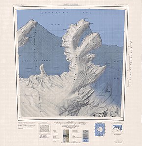
 Topografische Karte der Martin-Halbinsel mit dem Jacobsen Head (oben rechts) | ||
| Geographische Lage | ||
| Koordinaten | 74° 2′ S, 113° 35′ W | |
| Lage | Marie-Byrd-Land, Westantarktika | |
| Küste | Walgreen-Küste | |
| Gewässer | Amundsen-See | |
Das Jacobsen Head ist eine vereiste und kliffartige Landspitze an der Walgreen-Küste des westantarktischen Marie-Byrd-Lands. Sie bildet das nordöstliche Ende des Slichter Foreland auf der Martin-Halbinsel.
Der United States Geological Survey kartierte die Landspitze erstmals anhand von Luftaufnahmen der United States Navy bei der Operation Highjump (1946–1947) vom Januar 1947. Das Advisory Committee on Antarctic Names benannte sie 1967 nach Commander Glen Jacobsen (1916–1969), Kapitän des Eisbrechers USS Atka bei Erkundungsfahrten zwischen 1954 und 1955 auf der Suche nach Standorten für Forschungsstationen im Rahmen des Internationalen Geophysikalischen Jahres (1957–1958).
Weblinks
- Jacobsen Head im Geographic Names Information System des United States Geological Survey (englisch)
- Jacobsen Head auf geographic.org (englisch)
Auf dieser Seite verwendete Medien
1:250,000-scale topographic reconnaissance map of the Martin Peninsula area from 112°30'-117°W to 73°45'-75°S in Antarctica, including the eastern parts of the Getz Ice Shelf and the western parts of Dotson Ice Shelf. Mapped, edited and published by the U.S. Geological Survey in cooperation with the National Science Foundation.
Autor/Urheber: Alexrk2, Lizenz: CC BY-SA 3.0
Physische Positionskarte Antarktis, Mittabstandstreue Azimutalprojektion


