Jackson County (Indiana)
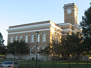
 Das Jackson County Courthouse in Brownstown, gelistet im NRHP | |
| Verwaltung | |
|---|---|
| US-Bundesstaat: | Indiana |
| Verwaltungssitz: | Brownstown |
| Gründung: | 1816 |
| Demographie | |
| Einwohner: | 46.428 (Stand: 2020) |
| Bevölkerungsdichte: | 35,2 Einwohner/km2 |
| Geographie | |
| Fläche gesamt: | 1331 km² |
| Wasserfläche: | 12 km² |
| Karte | |
 | |
Jackson County[1] ist ein County im Bundesstaat Indiana der Vereinigten Staaten. Der County Seat (Verwaltungssitz) ist Brownstown.
Geographie
Jackson County liegt im mittleren Süden von Indiana und hat eine Größe von 1331 Quadratkilometern, wovon zwölf Quadratkilometer Wasserfläche sind. Die Nachbar-Countys (im Norden startend, im Uhrzeigersinn) sind: Brown County, Bartholomew County, Jennings County, Scott County, Washington County, Lawrence County und Monroe County.
Geschichte
Das Jackson County wurde 1816 gebildet. Benannt wurde es nach Andrew Jackson, der 1812 im Britisch-Amerikanischen Krieg und 1815 in der Schlacht von New Orleans die Briten geschlagen hatte. Später wurde er Präsident der Vereinigten Staaten und unterzeichnete am 28. Mai 1830 den Indian Removal Act.
Im County fand durch die Reno Gang am 8. Oktober 1866 der erste nachweisbare Eisenbahnraub auf einen fahrenden Zug statt. Die Gang raubte rund 10.000 Dollar aus einem Zug der Ohio and Mississippi Railway.
1875 wurde die Medora Covered Bridge erbaut. Sie war zu dieser Zeit mit 132 Meter die längste auf drei Stützpfeilern aus Kalkstein stehende Holzbrücke. 1972 für den Fahrzeugverkehr gesperrt, blieb jedoch für Fußgänger geöffnet. Gelistet im NRHP.
Insgesamt sind 17 Bauwerke und Stätten des Countys im National Register of Historic Places eingetragen (Stand 2. September 2017).[2]
| Bevölkerungswachstum | |||
|---|---|---|---|
| Census | Einwohner | ± rel. | |
| 1820 | 4.010 | — | |
| 1830 | 4.870 | 21,4 % | |
| 1840 | 8.961 | 84 % | |
| 1850 | 11.047 | 23,3 % | |
| 1860 | 16.286 | 47,4 % | |
| 1870 | 18.974 | 16,5 % | |
| 1880 | 23.050 | 21,5 % | |
| 1890 | 24.139 | 4,7 % | |
| 1900 | 26.633 | 10,3 % | |
| 1910 | 24.727 | −7,2 % | |
| 1920 | 24.228 | −2 % | |
| 1930 | 23.731 | −2,1 % | |
| 1940 | 26.612 | 12,1 % | |
| 1950 | 28.237 | 6,1 % | |
| 1960 | 30.556 | 8,2 % | |
| 1970 | 33.187 | 8,6 % | |
| 1980 | 36.523 | 10,1 % | |
| 1990 | 37.730 | 3,3 % | |
| 2000 | 41.335 | 9,6 % | |
| 2010 | 42.376 | 2,5 % | |
| 2020 | 46.428 | 9,6 % | |
| Vor 1900[3] | |||
Orte im County
- Acme
- Bald Knobs
- Bobtown
- Brownstown
- Chestnut Ridge
- Clear Spring
- Cortland
- Crothersville
- Dudleytown
- Ewing
- Fleming
- Freetown
- Hangman Crossing
- Houston
- Kriete Corner
- Kurtz
- Little Acre
- Maumee
- Medora
- New Elizabethtown
- New Farmington
- Norman
- Reddington
- Retreat
- Rockford
- Seymour
- Shields
- Sparksville
- Spraytown
- Sunset Parkway
- Surprise
- Tampico
- Uniontown
- Vallonia
- Weddleville
- Wegan
- Brownstown Township
- Carr Township
- Driftwood Township
- Grassy Fork Township
- Hamilton Township
- Jackson Township
- Owen Township
- Pershing Township
- Redding Township
- Salt Creek Township
- Vernon Township
- Washington Township
Einzelnachweise
- ↑ GNIS-ID: 451678. Abgerufen am 22. Februar 2011 (englisch).
- ↑ Suchmaske Datenbank im National Register Information System. National Park Service, abgerufen am 2. September 2017.
- ↑ U.S. Census Bureau - Census of Population and Housing. Abgerufen am 15. März 2011
- ↑ Auszug aus Census.gov. Abgerufen am 15. Februar 2011
- ↑ Auszug aus census.gov (2000+2010) (Memento des vom 12. Juli 2011 auf WebCite) Info: Der Archivlink wurde automatisch eingesetzt und noch nicht geprüft. Bitte prüfe Original- und Archivlink gemäß Anleitung und entferne dann diesen Hinweis. Abgerufen am 2. April 2012
Weblinks
Koordinaten: 38° 55′ N, 86° 2′ W
Auf dieser Seite verwendete Medien
This is a locator map showing Jackson County in Indiana. For more information, see Commons:United States county locator maps.
Northern side and front of the Jackson County Courthouse, located along S. Main Street (U.S. Route 50) in downtown Brownstown, Indiana, United States. Built in 1870, the courthouse is listed on the National Register of Historic Places.
(c) Chris Light in der Wikipedia auf Englisch, CC BY-SA 3.0
The Medora Covered Bridge is a rare three span Burr Arch.


