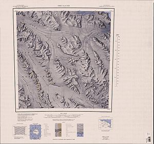
Jütland-Gletscher
| Jütland-Gletscher | ||
|---|---|---|
| Lage | Viktorialand, Ostantarktika | |
| Gebirge | Victory Mountains, Transantarktisches Gebirge | |
| Koordinaten | 71° 55′ S, 166° 12′ O | |
| Entwässerung | Greenwell-Gletscher | |
Mündungsgebiet am südlichen Kartenrand | ||
Ursprung am nördlichen Kartenrand | ||
Der Jütland-Gletscher ist ein 24 km langer und 6 km breiter Gletscher im ostantarktischen Viktorialand. In den Victory Mountains fließt er von der gemeinsamen Wasserscheide mit dem Midway-Gletscher zum Greenwell-Gletscher, den er nordwestlich des Boss Peak erreicht.
Der United States Geological Survey kartierte ihn anhand eigener Vermessungen und Luftaufnahmen der United States Navy aus den Jahren von 1960 bis 1963. Die Nordgruppe der New Zealand Federated Mountain Clubs Antarctic Expedition (1962–1963), die das Gebiet des Gletschers erkundete, benannte ihn nach der Schlacht von Jütland (englisch Battle of Jutland) im Ersten Weltkrieg, die im deutschen Sprachraum besser unter dem Namen Skagerrakschlacht bekannt ist.
Weblinks
- Jutland Glacier im Geographic Names Information System des United States Geological Survey (englisch)
- Jutland Glacier auf geographic.org (englisch)
Auf dieser Seite verwendete Medien
Autor/Urheber: Alexrk2, Lizenz: CC BY-SA 3.0
Physische Positionskarte Antarktis, Mittabstandstreue Azimutalprojektion
1:250,000-scale topographic reconnaissance map of the Ebbe Glacier area in the Admiralty Range from 165°-168°E to 71°-72°S in Antarctica, including Greenwell, Lillie and Tucker Glacier. Mapped, edited and published by the U.S. Geological Survey in cooperation with the National Science Foundation.
1:250,000-scale topographic reconnaissance map of the Cape Hallet area from 159°-162°E to 71°-72°S in Antarctica, including the Tucker Glacier. Mapped, edited and published by the U.S. Geological Survey in cooperation with the National Science Foundation.


