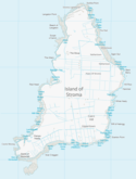
Island of Stroma
| Island of Stroma | ||
|---|---|---|
(c) J M Briscoe, CC BY-SA 2.0 | ||
| Gewässer | Pentland Firth (Atlantischer Ozean) | |
| Inselgruppe | Britische Inseln | |
| Geographische Lage | 58° 40′ 46″ N, 3° 7′ 4″ W | |
| Länge | 3,6 km | |
| Breite | 1,6 km | |
| Fläche | 3,75 km² | |
| Höchste Erhebung | Cairn Hill 53 m | |
| Einwohner | unbewohnt | |
| Hauptort | Uppertown (historisch) | |
Contains Ordnance Survey data © Crown copyright and database right (year), OS OpenData | ||
Das zur Parish Canisbay im Nordosten von Caithness gehörende unbewohnte Island of Stroma (altnordisch Straumey) liegt vor der schottischen Nordküste, drei Kilometer entfernt vom Hafen John o’ Groats im Pentland Firth, der das schottische Festland vom Archipel der Orkney trennt.
1901 waren noch 375 Menschen hier beheimatet. In den späten 1940er Jahren war die Zahl auf 111 gefallen. 1947 kaufte John Hoyland ein Schirmfabrikant aus Yorkshire die Insel[1] und es gelang ihm zunächst nicht, sie wieder zu veräußern, als die Bevölkerung zunehmend abwanderte. 1956 lebten nur noch sechzehn Personen, das Personal eines Leuchtturms eingeschlossen, auf Stroma. Die letzten Mitglieder der Familie Manson haben die Insel 1961 verlassen. Seit der Automatisierung des Leuchtturms 1996 ist die Insel unbewohnt und wird nun als Weidefläche für Schafe benutzt.[2]

Bilder
- Hausruinen auf Stroma
- Wrack der Bettina Danica
- Karte
Literatur
- Donald A. Young: Stroma. Edinburgh 1992, ISBN 1-871704-07-3.
Weblinks
Einzelnachweise
- ↑ Jimmy Simpson, owner of the isle of Stroma, heraldscotland.com, 13. Juni 2019
- ↑ Schottische Inseln - Stroma, schottland-wegweiser.de, abgerufen am 19. April 2023
Auf dieser Seite verwendete Medien
(c) J M Briscoe, CC BY-SA 2.0
Burial vault and doocot on Stroma - photograph taken from ferry on the way past. Stroma, Pentland Firth, Scotland
Autor/Urheber: Bruce Stokes from Coventry, Lizenz: CC BY-SA 2.0
View of Stroma from the Pentland Firth in choppy weather
(c) Kelisi aus der englischsprachigen Wikipedia, CC BY-SA 3.0
A map of the Pentland Firth, northern Scotland, showing various towns and villages on the British mainland and in Orkney, as well as physical features, including islands in the Firth. This map's source is here, with the uploader's modifications, and the GMT homepage says that the tools are released under the GNU General Public License.
Contains Ordnance Survey data © Crown copyright and database right (year), OS OpenData
Map of Stroma, Scotland
(c) Eric Gaba, NordNordWest, Uwe Dedering, CC BY-SA 3.0
Positionskarte von Schottland, Vereinigtes Königreich
Autor/Urheber: jack_spellingbacon, Lizenz: CC BY 2.0
The Danish coaster Bettina Danica shipwrecked in 1994 on Stroma Island.


