Isla Vista
| Isla Vista | ||
|---|---|---|
 „Willkommen in Isla Vista.“ | ||
| Lage in Kalifornien | ||
| Basisdaten | ||
| Staat: | Vereinigte Staaten | |
| Bundesstaat: | Kalifornien | |
| County: | Santa Barbara County | |
| Koordinaten: | 34° 25′ N, 119° 52′ W | |
| Zeitzone: | Pacific (UTC−8/−7) | |
| Einwohner: | 15.500 (Stand: 2020) | |
| Haushalte: | 4.661 (Stand: 2020) | |
| Fläche: | 5,7 km² (ca. 2 mi²) davon 5,5 km² (ca. 2 mi²) Land | |
| Bevölkerungsdichte: | 2.818 Einwohner je km² | |
| Höhe: | 14 m | |
| Postleitzahl: | 93117 | |
| Vorwahl: | +1 805 | |
| FIPS: | 06-36868 | |
| GNIS-ID: | 1702880 | |
Isla Vista ist ein census-designated place (CDP) im Santa Barbara County im US-Bundesstaat Kalifornien mit 15.500 Einwohnern (Stand: 2020).[1]
Bewohner sind hauptsächlich Undergraduate students der benachbarten UCSB (University of California, Santa Barbara). Jährlich werden Halloween-Feiern auf den Straßen des Wohngebiets und entlang der Kliffe abgehalten.
Siehe auch
Weblinks
Einzelnachweise
Auf dieser Seite verwendete Medien
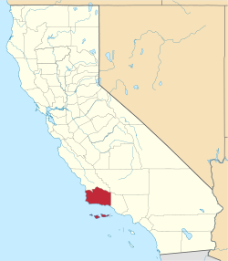
This is a locator map showing Santa Barbara County in Southern California.
Autor/Urheber: NordNordWest, Lizenz: CC BY 3.0
Positionskarte von Kalifornien, USA
Autor/Urheber: Die Autorenschaft wurde nicht in einer maschinell lesbaren Form angegeben. Es wird Alanmak~commonswiki als Autor angenommen (basierend auf den Rechteinhaber-Angaben)., Lizenz: CC BY-SA 3.0
Photographed by Alan Mak on September 3rd, 2005. The tree on the sign is the `Isla Vista Tree,' which stood at the edge of Sea Lookout Park at On el colegio rd. The tree fell off the edge of the bluff, and now there is only a plaque to commerorate it. The log of this tree recurs in a number of the community building efforts for Isla Vista.


