Ironwood Forest National Monument
| Ironwood Forest National Monument | ||
|---|---|---|
 | ||
| Lage: | Arizona, Vereinigte Staaten | |
| Nächste Stadt: | Tucson | |
| Fläche: | 522,1 km² | |
| Gründung: | 9. Juni 2000 | |
 | ||
 | ||
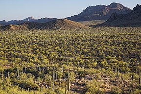
Das Ironwood Forest National Monument liegt in Arizona in den Vereinigten Staaten. Das National Monument wurde am 9. Juni 2000 gegründet und wird vom Bureau of Land Management verwaltet. Das Gebiet umfasst sowohl Land im Besitz der Regierung, des Bundesstaates Arizona und Privatbesitz. Das Gebiet beinhaltet sowohl Wüste als auch Wälder, in denen vorwiegend Harthölzer vorkommen, z. B. die Amerikanische Hainbuche und das namensgebende Wüsteneisenholz (Olneya tesota). Weiterhin befinden sich über 200 archäologisch wichtige Stätten der Hohokam-Kultur in diesem Gebiet.
Ironwood Forest National Monument
Im National Monument liegen immer noch Privatgrundstücke und diese sind nicht Teil vom National Monuments. Diese Privatgrundstücke können nur Teil des National Monuments werden, sofern sie freiwillig von den Vereinigten Staaten erworben werden können. Erwirbt der Bund Privatgrundstücke innerhalb des National Monument, so werden diese Grundstücke Teil des Schutzgebietes. Die Ausweisung des National Monuments hat keinen Einfluss auf die Rechte von Eigentümern von Grundstücken, welche sich nicht im Eigentum der USA befinden im oder an den Grenzen des Schutzgebietes. Bei der Errichtung des Schutzgebietes wurden auch bestehende Weiderechte privater Rinderfarmen auf dem Land im Bundeseigentum bestätigt.
Flora und Fauna
Innerhalb des Monuments sind 674 Pflanzen- und Tierarten nachgewiesen worden.
Es sind 560 Pflanzenarten dokumentiert. Ein kleines Vorkommen des vom Aussterben bedrohten Echinocactus horizonthalonius kommt in sehr lokal begrenzten kalksteinreichen Gebieten innerhalb des Monuments vor. Auch das Wüsteneisenholz (Olneya tesota) kommt vor. Das Wüsteneisenholz ist ein sehr langlebiger Baum, von dem einige Exemplare auf ein Alter von über 800 Jahren geschätzt werden.
Im Schutzgebiet gibt es 64 Säugetierarten und 57 Vogelarten. Die Kleine Mexikanische Blütenfledermaus wurde einmal nachgewiesen. Die Wüsten-Dickhornschafe innerhalb des Monuments sind die letzte verbliebene Reliktpopulation von Wüsten-Dickhornschafen im südöstlichen Arizona. Der Brasilzwergkauz wurden innerhalb und in der Nähe des Monuments gefunden.
Tourismus
Die Wege im Park sind teilweise nur schlecht ausgebaut. Touristen sollten ausreichend Wasser und Benzin mit sich führen, da es im Park keine Infrastruktur gibt. Campingplätze sind keine vorhanden, das Kampieren ist aber überall bis zu 14 Tage lang ohne Erlaubnis gestattet.
Quellen
- Ironwood Forest National Monument Resource Management Plan Reports, Bureau of Land Management, Arizona
Weblinks
- Ironwood Forest National Monument. Bureau of Land Management; offizielle Seite (englisch)
Auf dieser Seite verwendete Medien
Autor/Urheber: TUBS
Location map of the USA (Hawaii and Alaska shown in sidemaps).
Main map: EquiDistantConicProjection : Central parallel :
* N: 37.0° N
Central meridian :
* E: 96.0° W
Standard parallels:
* 1: 32.0° N
* 2: 42.0° N
Made with Natural Earth. Free vector and raster map data @ naturalearthdata.com.
Formulas for x and y:
x = 50.0 + 124.03149777329222 * ((1.9694462586094064-({{{2}}}* pi / 180))
      * sin(0.6010514667026994 * ({{{3}}} + 96) * pi / 180))
y = 50.0 + 1.6155950752393982 * 124.03149777329222 * 0.02613325650382181
      - 1.6155950752393982  * 124.03149777329222 *
     (1.3236744353715044  - (1.9694462586094064-({{{2}}}* pi / 180))
      * cos(0.6010514667026994 * ({{{3}}} + 96) * pi / 180))
Hawaii side map: Equirectangular projection, N/S stretching 107 %. Geographic limits of the map:
- N: 22.4° N
- S: 18.7° N
- W: 160.7° W
- E: 154.6° W
Alaska side map: Equirectangular projection, N/S stretching 210.0 %. Geographic limits of the map:
- N: 72.0° N
- S: 51.0° N
- W: 172.0° E
- E: 129.0° W
BLM Winter Bucket List #10: Ironwood Forest National Monument, Arizona, for Mild Temperatures and Winter Photography
Taking its name from one of the longest living trees in the Arizona desert, the Ironwood Forest National Monument protects 129,000 acres of spectacular Sonoran Desert mountains blanketed with saguaro cacti and ironwood trees. The winter light on the photogenic peaks - plus an average January high temperature of 65 degrees F - make the Ironwood an appealing wintertime public lands destination.
Ragged Top Mountain is the biological and geological crown jewel of the national monument. Several endangered and threatened species live here, including the Nichols turk’s head cactus and the lesser long-nosed bat. The national monument also contains habitat for the cactus ferruginous pygmy owl. The desert bighorn sheep dwelling in the region are the last viable population indigenous to the Tucson basin. The area holds abundant rock art sites and other archaeological objects of scientific interest.
Learn more about Ironwood Forest NM: www.blm.gov/az/st/en/prog/blm_special_areas/natmon/ironwo...
Photos by Bob Wick, BLMAutor/Urheber: Bob Wick; Bureau of Land Management, Lizenz: CC BY 2.0
mypubliclandsroadtrip continues this week with Something Different -- some of the most unique locations by the BLM, from film locations to geologic wonders to speedways.
Our Something Different posts begin in a desert forest of giants. Taking its name from one of the longest living trees in the Arizona desert, the 129,000-acre Ironwood Forest National Monument is a true Sonoran Desert showcase. Keeping company with the ironwood trees are mesquite, palo verde, creosote, and saguaro, blanketing the monument floor beneath rugged mountain ranges named Silver Bell, Waterman and Sawtooth. In between, desert valleys lay quietly to complete the setting.
Elevations here range from 1,800 to more than 4,200 feet. Ragged Top Mountain is the biological and geological crown jewel of the national monument. Several endangered and threatened species live here, including the Nichols turk’s head cactus and the lesser long-nosed bat. The national monument also contains habitat for the cactus ferruginous pygmy owl and desert bighorn sheep dwelling, which makes hiking, wildlife watching and photography favorite activities in this desert jewel.Map of Ironwood Forest National Monument — located in Pima County and Pinal County, southern Arizona.
- Managed by the BLM−Bureau of Land Management.
- Indicating the locations of the Silver Bell Mountains and West Silver Bell Mountains (mountain ranges).


