Interstate 805
 | |||||||||||||||||||||||||||||||||||||||||||||||||||||||||||||||||||||||||||||||||||||||||||||||||||||||||||||||||||
| Basisdaten | |||||||||||||||||||||||||||||||||||||||||||||||||||||||||||||||||||||||||||||||||||||||||||||||||||||||||||||||||||
|---|---|---|---|---|---|---|---|---|---|---|---|---|---|---|---|---|---|---|---|---|---|---|---|---|---|---|---|---|---|---|---|---|---|---|---|---|---|---|---|---|---|---|---|---|---|---|---|---|---|---|---|---|---|---|---|---|---|---|---|---|---|---|---|---|---|---|---|---|---|---|---|---|---|---|---|---|---|---|---|---|---|---|---|---|---|---|---|---|---|---|---|---|---|---|---|---|---|---|---|---|---|---|---|---|---|---|---|---|---|---|---|---|---|---|---|
| Länge: | 29 mi/46 km | ||||||||||||||||||||||||||||||||||||||||||||||||||||||||||||||||||||||||||||||||||||||||||||||||||||||||||||||||||
| Bundesstaat: | Kalifornien | ||||||||||||||||||||||||||||||||||||||||||||||||||||||||||||||||||||||||||||||||||||||||||||||||||||||||||||||||||
| Karte | |||||||||||||||||||||||||||||||||||||||||||||||||||||||||||||||||||||||||||||||||||||||||||||||||||||||||||||||||||
 | |||||||||||||||||||||||||||||||||||||||||||||||||||||||||||||||||||||||||||||||||||||||||||||||||||||||||||||||||||
Verlauf
| |||||||||||||||||||||||||||||||||||||||||||||||||||||||||||||||||||||||||||||||||||||||||||||||||||||||||||||||||||
Die Interstate 805 (kurz I-805) ist ein Interstate Highway in den Vereinigten Staaten und verläuft bei San Diego in Kalifornien parallel zur Interstate 5.
Verlauf
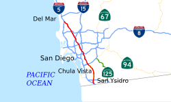
Die I-805, auch als Jacob Dekema Freeway oder einfach die 805 dient als Umgehung der I-5 in der Metropolregion von San Diego. Im Süden beginnt sie an der I-5 direkt nach der Grenze zu Mexiko und führt dann durch die Städte Chula Vista und National City sowie Mira Mesa, einem Stadtteil von San Diego. Bis zum Ort Chula Vista besteht die Interstate aus acht bis zehn Fahrspuren. Im weiteren Verlauf durchquert sie unter anderem einige Gewerbegebiete von San Diego am Sorrento Valley, bis sie in der Nähe des Carmel Valleys wieder auf die Interstate 5 trifft.
Die I-805 führt mit einer hohen Brücke über das Misson Valley.
Das nördliche Dreieck mit der Interstate 5 wurde erweitert und Anfang April 2007 für den Verkehr freigegeben. An der breitesten Stelle umfasst die Interstate in diesem Bereich inklusive der HOV-Fahrspuren 22 Fahrspuren. Entlang der I-805 haben sich viele Firmen angesiedelt. Sie ist eine von zwei Nord-Süd-Interstates in Kalifornien, die fast bis zur mexikanischen Grenze führen.
Geschichte
Erste Pläne zum Bau der Straße wurden 1959 veröffentlicht. Sie wurde als Interstate genehmigt und später aber als State Route ausgezeichnet. Zwischen 1970 und 1975 wurde die Straße als Interstate gebaut.
Weblinks
- California @ AARoads Streckenbeschreibung mit Fotos (englisch)
- California Highways (englisch)

Auf dieser Seite verwendete Medien
25 in by 30 in (635 mm by 762 mm) Interstate shield, made to the specifications of the 1971 Caltrans sign drawing (still in use). Uses the Roadgeek 2005 fonts. (United States law does not permit the copyrighting of typeface designs, and the fonts are meant to be copies of a U.S. Government-produced work anyway.) Colors are from [1] (Pantone Red 187 and Blue 294), converted to RGB by [2]. The outside border has a width of 1 and a color of black so it shows up; in reality, signs have no outside border.
Autor/Urheber: User:Rschen7754, Lizenz: CC BY-SA 3.0
This is a map of Interstate 805, created in w:Quantum GIS.
Vector image of a 24 in by 25 in (600 mm by 635 mm) California State Route shield. Colors are from [1] (Pantone Green 342), converted to RGB by [2]. The outside border has a width of 1 (1/16 in) and a color of black so it shows up; in reality, signs have no outside border.
Vector image of a 24 in by 25 in (600 mm by 635 mm) California State Route shield. Colors are from [1] (Pantone Green 342), converted to RGB by [2]. The outside border has a width of 1 (1/16 in) and a color of black so it shows up; in reality, signs have no outside border.
Vector image of a 24 in by 25 in (600 mm by 635 mm) California State Route shield. Colors are from [1] (Pantone Green 342), converted to RGB by [2]. The outside border has a width of 1 (1/16 in) and a color of black so it shows up; in reality, signs have no outside border.
Vector image of a 24 in by 25 in (600 mm by 635 mm) California State Route shield. Colors are from [1] (Pantone Green 342), converted to RGB by [2]. The outside border has a width of 1 (1/16 in) and a color of black so it shows up; in reality, signs have no outside border.
Vector image of a 24 in by 25 in (600 mm by 635 mm) California State Route shield. Colors are from [1] (Pantone Green 342), converted to RGB by [2]. The outside border has a width of 1 (1/16 in) and a color of black so it shows up; in reality, signs have no outside border.
Autor/Urheber: Curimedia, Lizenz: CC BY 2.0
United States of America West Coast Trip 2012
Vector image of a 24 in by 25 in (600 mm by 635 mm) California State Route shield. Colors are from [1] (Pantone Green 342), converted to RGB by [2]. The outside border has a width of 1 (1/16 in) and a color of black so it shows up; in reality, signs have no outside border.
Vector image of a 24 in by 25 in (600 mm by 635 mm) California State Route shield. Colors are from [1] (Pantone Green 342), converted to RGB by [2]. The outside border has a width of 1 (1/16 in) and a color of black so it shows up; in reality, signs have no outside border.


