Interstate 580 (Nevada)
 | |
| Basisdaten | |
|---|---|
| Länge: | 4,99 mi/8,03 km |
| Bundesstaat: | Nevada |
| Verlaufsrichtung: | Nord-Süd |
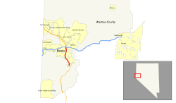
| Karte | |
 | |
Die Interstate 580 (kurz I-580) ist ein Interstate Highway im Nordwesten Nevadas. Als Zubringer der Interstate 80 schließt sie in Reno an das Interstate-Highway-System an, ist aber offiziell nicht ausgeschildert und nutzt die Trasse des U.S. Highways 395.
Verlauf
Die Interstate 580 beginnt im Süden von Reno an der Neil Road. Sie passiert im Westen das Atlantis Casino Resort und an der Abfahrt 65 im Osten den Reno-Tahoe International Airport. Nach acht Kilometern endet die I-580 am Kreuz mit der Interstate 80 nordöstlich des Stadtzentrums nahe dem Governors Bowl Park.
Planungen
Zwei Erweiterungsprojekte sollen den Highway insgesamt bis zur südlichen Stadtgrenze von Carson City, der Hauptstadt Nevadas, verlängern.
Weblinks
- Interstate-Guide (englisch)
- Nevada @ AARoads Streckenbeschreibung mit Fotos (englisch)
- Freeway-Extension-Projekt der I-580 (englisch)
Auf dieser Seite verwendete Medien
Nevada State Route 648
Nevada State Route 653
600 mm by 600 mm (24 in by 24 in) Interstate shield, made to the specifications of the 2004 edition of Standard Highway Signs (sign M1-1). Uses the Roadgeek 2005 fonts. (United States law does not permit the copyrighting of typeface designs, and the fonts are meant to be copies of a U.S. Government-produced work anyway.) Colors are from [1] (Pantone Red 187 and Blue 294), converted to RGB by [2]. The outside border has a width of 1 (1 mm) and a color of black so it shows up; in reality, signs have no outside border.


