Interstate 580 (Kalifornien)
| Basisdaten | |
|---|---|
| Länge: | 79,97 mi/128,70 km |
| Bundesstaat: | Kalifornien |
| Verlaufsrichtung: | Ost-West |
| Karte | |
 | |
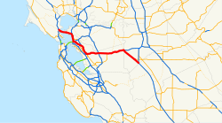
Die Interstate 580 (kurz I-580) ist ein Interstate Highway der als Ausläufer der Interstate 80 in der San Francisco Bay Area im nördlichen Kalifornien eine Verbindung zur Interstate 5 herstellt. Einige Teile der Strecke Tragen Namen, so wie MacArthur Freeway, John T. Knox Freeway, Eastshore Freeway, Arthur H. Breed Jr. Freeway und William Elton “Brownie” Brown Freeway
Diese Strecke ist Teil des California Freeway and Expressway System[1] und kommt für das State Scenic Highway System[2] infrage. Die Blue S Linie des Bay Area Rapid Transit verläuft teilweise zwischen den Richtungsfahrbahnen der I-580.
Einzelnachweise
- ↑ CA Codes (shc:250-257) (Memento des Originals vom 14. Oktober 2012 im Internet Archive) Info: Der Archivlink wurde automatisch eingesetzt und noch nicht geprüft. Bitte prüfe Original- und Archivlink gemäß Anleitung und entferne dann diesen Hinweis.
- ↑ CA Codes (shc:260-284) (Memento des Originals vom 3. November 2010 im Internet Archive) Info: Der Archivlink wurde automatisch eingesetzt und noch nicht geprüft. Bitte prüfe Original- und Archivlink gemäß Anleitung und entferne dann diesen Hinweis.
Weblinks
- Interstate-Guide (englisch)
- AARoads (englisch)

Auf dieser Seite verwendete Medien
This is a map of Interstate 580 in California.
Autor/Urheber: User Minesweeper on en.wikipedia, Lizenz: CC BY-SA 3.0
Looking south above en:Interstate 80, the Eastshore Freeway, near en:Berkeley, California on a Saturday afternoon. en:Emeryville, California is at the towers, en:Aquatic Park (Berkeley) is visible to the left. To the right is the east shore of the en:San Francisco Bay. Picture taken by Minesweeper on May 14, 2005.
25 in by 30 in (625 mm by 750 mm) Interstate shield, made to the specifications of the 1971 Caltrans sign drawing (still in use). Uses the Roadgeek 2005 fonts. (United States law does not permit the copyrighting of typeface designs, and the fonts are meant to be copies of a U.S. Government-produced work anyway.) Colors are from [1] (Pantone Red 187 and Blue 294), converted to RGB by [2]. The outside border has a width of 1 and a color of black so it shows up; in reality, signs have no outside border.
600 mm by 600 mm (24 in by 24 in) Interstate shield, made to the specifications of the 2004 edition of Standard Highway Signs (sign M1-1). Uses the Roadgeek 2005 fonts. (United States law does not permit the copyrighting of typeface designs, and the fonts are meant to be copies of a U.S. Government-produced work anyway.) Colors are from [1] (Pantone Red 187 and Blue 294), converted to RGB by [2]. The outside border has a width of 1 (1 mm) and a color of black so it shows up; in reality, signs have no outside border.


