Interstate 37
| Basisdaten | ||||||||||
|---|---|---|---|---|---|---|---|---|---|---|
| Länge: | 143 mi/230.14 km | |||||||||
| Bundesstaat: | Texas | |||||||||
| Karte | ||||||||||
 | ||||||||||
Verlauf
| ||||||||||
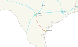
Die Interstate 37 (Kurz I-37) ist ein Teil des Interstate-Highway-Systems der Vereinigten Staaten. Sie beginnt an der Kreuzung mit U.S. Highway 131 und Texas State Highway 35 in Corpus Christi und endet an der Interstate 35 in San Antonio. Die Interstate wurde im Jahr 1959 eröffnet.
Weblinks
- Interstate Guide (englisch)
- Infos und Bilder zur Interstate 8 (englisch)
- AARoads (englisch)


