Interstate 22
 | |
| Basisdaten | |
|---|---|
| Länge: | 325,9 km (202,5 Meilen) |
| Bundesstaaten: | Mississippi Alabama |
| Verlaufsrichtung: | West-Ost |
| Karte | |
 | |
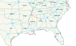
Die Interstate 22 ist ein Interstate Highway in den Bundesstaaten Mississippi und Alabama in den Vereinigten Staaten. Sie verbindet die Großstädte Memphis und Birmingham auf einer Strecke von etwa 326 km.
Verlauf

Mississippi
Die Straße beginnt an ihrem Westende im Norden des Bundesstaats Mississippi an einem Autobahnkreuz mit der Interstate 269, circa 26 Meilen südöstlich von Memphis in Tennessee. Nach Westen wird die I-22 von dem U.S. Highway 78 weitergeführt, mit dem sie auf fast ihrer gesamten Strecke bis kurz vor Birmingham gleichbedeutend ist, die Straße also sowohl als I-22 als auch als US 78 ausgeschildert ist.[1] Von dort führt sie in südöstliche Richtung, durch die Stadt Holly Springs und durch den Holly Springs National Forest. Weiter werden die Städte New Albany und Tupelo durchquert, wo die Interstate vom U.S. Highway 45 gekreuzt wird. Nach der Überquerung des Tennessee-Tombigbee Waterway bei Fulton überquert die Straße die Grenze zu Alabama.
Alabama
Im Westen von Alabama führt die Interstate vorbei an der Stadt Hamilton, überquert den Buttahatchee River und wird von der US 278 gekreuzt. Die nächste größere Stadt an der Strecke ist Jasper, bevor die I-22 die Flüsse Mulberry Fork und Locust Fork überquert. Kurz darauf trennt sich der U.S. Highway 78 bei Graysville an einem Kreuz mit der Alabama State Route 5 von der Interstate und führt nach Süden. Die Interstate 22 führt von dort noch einige Kilometer weiter durch bewaldete und vorstädtische Landschaft, bis sie an der Interstate 65 nördlich von Birmingham endet.[2]
Weblinks
Einzelnachweise
- ↑ interstate-guide.com: Interstate 22. Abgerufen am 19. März 2019 (englisch)
- ↑ SCOH ReportFromSpecial Committee on U.S. Route Numbering Annual Meeting. Abgerufen am 19. März 2019 (PDF, englisch)
Auf dieser Seite verwendete Medien
750 mm × 600 mm (30 in × 24 in) U.S. Highway shield, made to the specifications of the 2004 edition of Standard Highway Signs. (Note that there is a missing "J" label on the left side of the diagram.) Uses the Roadgeek 2005 fonts. (United States law does not permit the copyrighting of typeface designs, and the fonts are meant to be copies of a U.S. Government-produced work anyway.)
600 mm × 600 mm (24 in × 24 in) U.S. Highway shield, made to the specifications of the 2004 edition of Standard Highway Signs. (Note that there is a missing "J" label on the left side of the diagram.) Uses the Roadgeek 2005 fonts. (United States law does not permit the copyrighting of typeface designs, and the fonts are meant to be copies of a U.S. Government-produced work anyway.)
750 mm by 600 mm (30 in by 24 in) Interstate shield, made to the specifications of the 2004 edition of Standard Highway Signs (sign M1-1). Uses the Roadgeek 2005 fonts. (United States law does not permit the copyrighting of typeface designs, and the fonts are meant to be copies of a U.S. Government-produced work anyway.) Colors are from [1] (Pantone Red 187 and Blue 294), converted to RGB by [2]. The outside border has a width of 1 (1 mm) and a color of black so it shows up; in reality, signs have no outside border.
600 mm × 600 mm (24 in × 24 in) U.S. Highway shield, made to the specifications of the 2004 edition of Standard Highway Signs. (Note that there is a missing "J" label on the left side of the diagram.) Uses the Roadgeek 2005 fonts. (United States law does not permit the copyrighting of typeface designs, and the fonts are meant to be copies of a U.S. Government-produced work anyway.)
Autor/Urheber: Patriarca12, Lizenz: CC BY-SA 3.0
Interstate 22 (Corridor X and U.S. Route 78) eastbound at Potts Camp, Mississippi
Autor/Urheber: Interstate US Route, Lizenz: CC BY-SA 4.0
Map of I-22 highlighted in red.


