Inglewood (Nebraska)
| Inglewood | |
|---|---|
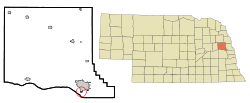
Lage in Nebraska | |
| Basisdaten | |
| Staat: | Vereinigte Staaten |
| Bundesstaat: | Nebraska |
| County: | Dodge County |
| Koordinaten: | 41° 25′ N, 96° 30′ W |
| Zeitzone: | Central (UTC−6/−5) |
| Einwohner: | 380 (Stand: 2020) |
| Haushalte: | 249 (Stand: 2020) |
| Fläche: | 0,6 km² (ca. 0 mi²) davon 0,6 km² (ca. 0 mi²) Land |
| Bevölkerungsdichte: | 633 Einwohner je km² |
| Höhe: | 364 m |
| FIPS: | 31-23970 |
| GNIS-ID: | 0830297 |
Inglewood ist ein Dorf in Dodge County im US-Bundesstaat Nebraska. Inglewood liegt nahe dem Platte River etwa 57 Kilometer von Omaha entfernt.
Auf dieser Seite verwendete Medien
Autor/Urheber: Arkyan, Lizenz: CC BY-SA 3.0
This map shows the incorporated and unincorporated areas in Dodge County, Nebraska, highlighting Inglewood in red. It was created with a custom script with US Census Bureau data and modified with Inkscape.
This is a locator map showing Dodge County in Nebraska. For more information, see Commons:United States county locator maps.


