IC 4596
| Galaxie IC 4596 | |
|---|---|
| AladinLite | |
| Sternbild | Skorpion |
| Position Äquinoktium: J2000.0, Epoche: J2000.0 | |
| Rektaszension | 16h 16m 03,6s[1] |
| Deklination | -22° 37′ 31″ [1] |
| Erscheinungsbild | |
| Morphologischer Typ | (R')SB(r)ab [1][2] |
| Helligkeit (visuell) | 14,7 mag [2] |
| Helligkeit (B-Band) | 15,5 mag [2] |
| Winkelausdehnung | 1,50' × 0,5' [2] |
| Positionswinkel | 54° [2] |
| Flächenhelligkeit | 14,2 mag/arcmin² [2] |
| Physikalische Daten | |
| Rotverschiebung | 0.025251 ± 0.000123 [1] |
| Radialgeschwindigkeit | 7570 ± 37 km/s [1] |
| Hubbledistanz vrad / H0 | (338 ± 24) · 106 Lj (103,5 ± 7,3) Mpc [1] |
| Geschichte | |
| Entdeckung | DeLisle Stewart |
| Entdeckungsdatum | 7. Juli 1899 |
| Katalogbezeichnungen | |
| IC 4596 • PGC 57665 • ESO 516-009 • MCG -04-38-005 • 2MASX J16160361-2237314 • SGC 161305-2230.1 • | |
IC 4596 ist eine Balken-Spiralgalaxie vom Hubble-Typ SBab im Sternbild Skorpion am Südsternhimmel. Sie ist schätzungsweise 338 Millionen Lichtjahre von der Milchstraße entfernt und hat einen Durchmesser von etwa 150.000 Lichtjahren.
Im selben Himmelsareal befindet sich u. a. die Galaxie IC 4600.
Die Typ-IIn-Supernova SN 2006dc wurde hier beobachtet.[3]
Das Objekt wurde am 7. Juli 1899 von DeLisle Stewart entdeckt.[4]
Siehe auch
Weblinks
Einzelnachweise
Auf dieser Seite verwendete Medien
Autor/Urheber: Torsten Bronger., Lizenz: CC BY-SA 3.0
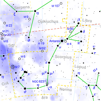
This is a celestial map of the constellation Scorpius, the Scorpion.
The yellow dashed lines are constellation boundaries, the red dashed line is the ecliptic, and the shades of blue show Milky Way areas of different brightness. The map contains all Messier objects, except for colliding ones. The underlying database contains all stars brighter than 6.5. All coordinates refer to equinox 2000.0.
The map is calculated with the equidistant azimuthal projection (the zenith being in the center of the image). The north pole is to the top. The (horizontal) lines of equal declination are drawn for 0°, ±10°, ±20° etc. The lines of equal right ascension are drawn for all 24 hours. Towards the rim there is a very slight magnification (and distortion).

