Interstate 90
 | |||||||||||||||||||||||||||||||||||||||||||||||||||||||||||||||||||||||||||||||||||||||||||||||||||||||||||||||||||||||||||||||||||||||||||||||||||||||||||||||||||
| Basisdaten | |||||||||||||||||||||||||||||||||||||||||||||||||||||||||||||||||||||||||||||||||||||||||||||||||||||||||||||||||||||||||||||||||||||||||||||||||||||||||||||||||||
|---|---|---|---|---|---|---|---|---|---|---|---|---|---|---|---|---|---|---|---|---|---|---|---|---|---|---|---|---|---|---|---|---|---|---|---|---|---|---|---|---|---|---|---|---|---|---|---|---|---|---|---|---|---|---|---|---|---|---|---|---|---|---|---|---|---|---|---|---|---|---|---|---|---|---|---|---|---|---|---|---|---|---|---|---|---|---|---|---|---|---|---|---|---|---|---|---|---|---|---|---|---|---|---|---|---|---|---|---|---|---|---|---|---|---|---|---|---|---|---|---|---|---|---|---|---|---|---|---|---|---|---|---|---|---|---|---|---|---|---|---|---|---|---|---|---|---|---|---|---|---|---|---|---|---|---|---|---|---|---|---|---|---|---|
| Länge: | 3099 Meilen / 4958 Kilometer | ||||||||||||||||||||||||||||||||||||||||||||||||||||||||||||||||||||||||||||||||||||||||||||||||||||||||||||||||||||||||||||||||||||||||||||||||||||||||||||||||||
| Bundesstaaten: | Washington Idaho Montana Wyoming South Dakota Minnesota Wisconsin Illinois Indiana Ohio Pennsylvania New York Massachusetts | ||||||||||||||||||||||||||||||||||||||||||||||||||||||||||||||||||||||||||||||||||||||||||||||||||||||||||||||||||||||||||||||||||||||||||||||||||||||||||||||||||
| Karte | |||||||||||||||||||||||||||||||||||||||||||||||||||||||||||||||||||||||||||||||||||||||||||||||||||||||||||||||||||||||||||||||||||||||||||||||||||||||||||||||||||
 | |||||||||||||||||||||||||||||||||||||||||||||||||||||||||||||||||||||||||||||||||||||||||||||||||||||||||||||||||||||||||||||||||||||||||||||||||||||||||||||||||||
Verlauf
| |||||||||||||||||||||||||||||||||||||||||||||||||||||||||||||||||||||||||||||||||||||||||||||||||||||||||||||||||||||||||||||||||||||||||||||||||||||||||||||||||||
Der Interstate Highway 90, kurz I-90, ist mit einer Länge von 4959 Kilometern oder 3099 Meilen der längste Interstate Highway der Vereinigten Staaten. Er bildet die nördlichste der großen von Küste zu Küste verlaufenden Ost-West-Achsen und verbindet Seattle in Washington mit Boston, Massachusetts, wobei insgesamt 13 Bundesstaaten durchquert werden. Östlich der Staatsgrenze zu New York wird die Strecke auch als Massachusetts Turnpike bezeichnet. Die größten und wichtigsten Städte, die durch die I-90 angebunden werden, sind (neben Seattle und Boston) Chicago und Cleveland. Daneben bildet die I-90 in Washington, Montana, South Dakota, Ohio, New York State und Massachusetts den Hauptverkehrs- und Siedlungskorridor in ansonsten relativ dünn besiedelten Regionen. Im Vergleich zu den parallel verlaufenden südlicheren Ost-West-Achsen liegen relativ wenige Großstädte entlang der Strecke. Einige Streckenabschnitte teilt sich die I-90 mit der noch weiter nördlich verlaufenden I-94, die allerdings nicht vollständig von Küste zu Küste verläuft. Außerdem gibt es einen gemeinsamen Abschnitt mit der I-80.
In den östlichen Bundesstaaten gilt meist eine Höchstgeschwindigkeit von 65 mph (etwa 105 km/h), während sie in den weitläufigen westlicheren Staaten in der Regel bei 75 mph (120 km/h) liegt. Östlich der Grenze Wisconsin/Illinois ist die I-90 größtenteils mautpflichtig.
Streckenverlauf
Die Interstate 90 beginnt südlich der Innenstadt von Seattle als Abzweigung von der Nord-Süd-Achse Interstate 5. Anschließend wird der Lake Washington, der Seattle von seinen östlichen Vororten trennt, via zwei der längsten Schwimmbrücken der Welt überquert, die Lacey V. Murrow Memorial Bridge (ostwärts) und die Homer M. Hadley Memorial Bridge (westwärts). Hierbei wird auch die Insel und Stadt Mercer Island angebunden. Am gegenüberliegenden Ufer erreicht der Highway die Stadt Bellevue und kreuzt hier die I-405, eine Parallelstrecke der I-5. Nun verlässt die Strecke den Großraum Seattle und steuert entlang des South Fork Snoqualmie River in südöstlicher Richtung die Berge der Kaskadenkette an. Nach passieren des Snoqualmie Pass folgt die Autobahn dem Yakima River aus den Bergen heraus ins Columbia Plateau im Zentrum Washingtons. Bei der ersten größeren Ortschaft Ellensburg zweigt die Interstate 82 von der I-90 ab, um die südlicheren Gebiete des Plateaus anzuschließen und mit der I-84 in Oregon zu verbinden. Gute 40 Kilometer weiter östlich bei der Ortschaft Vantage überquert die I-90 den Columbia River, den größten Fluss der Pacific-Northwest Region, der hier über 1,5 Kilometer breit ist. Anschließend passiert sie die Stadt Moses Lake und läuft dann in nordöstlicher Richtung auf Spokane zu, die größte Stadt im Osten Washingtons. Im Stadtgebiet kreuzt die Strecke die wichtigen US-Highways 2 und 195.
Hinter Spokane erreicht die I-90 den Norden Idahos mit der Stadt Coeur d’Alene. Der Idaho Panhandle ist in dieser Gegend keine 100 Kilometer breit, weshalb der Abschnitt durch diesen Bundesstaat der zweitkürzeste der I-90 ist. Gleichzeitig erreicht der Highway hier seinen nördlichsten Punkt auf dem Gebiet der Gemeinde Post Falls. Anschließend führt der Streckenverlauf wieder in südöstlicher Richtung durch dünn besiedelte und dicht bewaldete Berglandschaften als Teil der Rocky Mountains (Bitterroot Range). Am markanten Lookout Pass auf 1,436 Metern Höhe erreicht die I-90 die Grenze zu Montana.
In Montana behält der Highway seine Richtung zunächst bei und folgt der Clark Fork nach Missoula, der zweitgrößten Stadt des Bundesstaats, wo die US Highways 93 und 12 die Strecke kreuzen. Weiter entlang des Clark Fork Valleys erreicht die Strecke das Zentrum des Kupferbergbaus in den USA mit den Städten Anaconda und Butte. Zwischen den beiden Städten kommt die Interstate 15 von Süden aus an der I-90 an und teilt sich auf dem Gebiet der Stadt Butte für ein kurzes Stück den Streckenverlauf mit dieser, bevor sie am östlichen Stadtrand wieder in nördlicher Richtung abzweigt. Zusätzlich gibt es in Butte mit der I-115 eine kleine Zubringerautobahn, die direkt ins Stadtzentrum führt. Östlich von Butte überquert die I-90 die Continental Divide und erreicht bei Three Forks das Quellgebiet des Missouri River. Wenig weiter östlich durchquert sie die Städte Belgrade und Bozeman. Knappe 40 Kilometer weiter östlich überquert die Autobahn den Yellowstone River bei der Stadt Livingston, welche auch als nördliches „Tor zum Yellowstone Park“ bekannt ist. Jener bekannte Nationalpark liegt direkt südlich der Strecke. Nun verlässt die I-90 die Berge und führt durch die weiten Prärielandschaften Ost-Montanas entlang des Yellowstone Rivers. Hier passiert die Autobahn mit Billings die größte Stadt Montanas. Direkt östlich der Stadt beginnt die I-94, der wichtigste Parallelhighway der I-90, welcher weiter dem Yellowstone River in Richtung North Dakota folgt, während die I-90 den Flusslauf verlässt und in östlicher Richtung auf den Zusammenfluss von Bighorn und Little Bighorn River bei der Ortschaft Hardin zusteuert. Anschließend folgt sie dem Little Bighorn River nach Süden bis zur Grenze zu Wyoming.
In Wyoming verläuft die Interstate 90 östlich des Bighorn National Forest und bindet die Städte Sheridan und Buffalo an. In Buffalo mündet die von Süden kommende I-25 in der I-90, eine wichtige Nord-Süd-Verbindung nach Colorado und New Mexico. Die I-90 beginnt hier langsam von einer südöstlichen in eine östliche Richtung überzugehen und durchquert dabei das menschenleere Becken des Powder River. Erst 100 Kilometer weiter östlich wird mit der Stadt Gillette wieder bewohntes Gebiet erreicht. Kurz vor der Grenze zu South Dakota führt die I-90 durch ein breites Tal zwischen dem nordwestlichen und dem Hauptteil der Black Hills, mit der Ortschaft Sundance.
In South Dakota verläuft die I-90 am nordöstlichen Rand der Black Hills und durchquert dabei die Städte Spearfish, Sturgis und Rapid City. Letztere besitzt als zweitgrößte Stadt des Bundesstaates eine eigene Zubringerautobahn I-190 ins Stadtzentrum. Hinter Rapid City beginnt die I-90 ihren langen und vergleichsweise geraden Abschnitt durch die nördlichen Great Plains der USA. Im dünn besiedelten South Dakota bildet sie die Hauptsiedlungsachse. Zunächst verläuft sie nördlich des Badlands National Park entlang zahlreicher kleiner Dörfer, bevor sie etwa 300 Kilometer östlich von Rapid City den aufgestauten Missouri River erreicht. Sie quert den Fluss über die Lewis and Clark Memorial Bridge und erreicht am gegenüberliegenden Ufer die nächste nennenswerte Ortschaft namens Chamberlain. Auf halber Strecke zwischen Chamberlain und Sioux Falls liegt noch die Kleinstadt Mitchell. In Sioux Falls, der größten Stadt South Dakotas verläuft die I-90 nicht direkt durch das Stadtzentrum, sondern entlang der nördlichen Stadtgrenze. Hier trifft sie auf die Nord-Süd-Achse I-29 und deren Parallelstrecke I-229.
Östlich von Sioux Falls erreicht die I-90 den äußersten Südwesten Minnesotas und verläuft weiter quer durch den Süden des Bundesstaates parallel zur Grenze mit Iowa. Auch dieser Abschnitt ist von einer sehr dünnen Besiedelung geprägt und der große Ballungsraum von Minneapolis/St. Paul wird umgangen, da dieser bereits durch die I-94 angebunden wird. Die einzigen nennenswerten Städte auf diesem Abschnitt sind Worthington, wo der US-Highway 59 kreuzt, sowie Albert Lea, wo die I-90 auf die I-35 trifft, die weiter nördlich nach Minneapolis führt. Erst rund 90 Kilometer weiter nordöstlich von Albert Lea erreicht die I-90 mit Rochester die erste Großstadt in Minnesota, wobei die Stadt weiträumig umgangen und stattdessen von den US-Highways 63 und 52 angebunden wird. Hier verlässt die Strecke langsam die Great Plains, die hier in die von bewaldeten Flusstälern geprägte Driftless Area übergeht.
Die Grenze zu Wisconsin erreicht die I-90 etwa 90 Kilometer östlich von Rochester am Mississippi River. Sie überquert den größten Fluss der USA über die Dresbach Bridge und French Island. Am gegenüberliegenden Ufer erreicht sie die Städte La Crosse und Onalaska. Anschließend folgt sie dem La Crosse River weiter durch die hügelige, bewaldete Driftless Area, bis sie bei Tomah wieder auf die I-94 trifft, die von Nordwesten kommend ab hier ihren Streckenverlauf für ein kurzes Stück mit der I-90 teilt. Ab hier führt die I-90 in südöstlicher Richtung durch das südliche Zentrum Wisconsins, wo sie den namensgebenden Wisconsin River kreuzt und die Stadt Wisconsin Dells anbindet, bevor sie mit Madison die Hauptstadt und zweitgrößte Stadt des Bundesstaates erreicht. In Madison zweigt die I-94 wieder von der I-90 ab, um in östlicher Richtung Milwaukee anzubinden. Die I-90 führt weiter in Richtung Süden und erreicht nahe der Grenze zu Illinois die Städte Janesville und Beloit am Rock River. In Beloit mündet die von Milwaukee kommende I-43 in der I-90.
Direkt südlich von Beloit erreicht die I-90 Illinois und die Stadt South Beloit. Immer weiter parallel östlich zum Rock River verlaufend, erreicht die I-90 die Großstadt Rockford, die drittgrößte Stadt des Bundesstaates, welche sie ebenfalls östlich umgeht, während der US Highway 20 BUS das Stadtzentrum anbindet. Im Südwesten Rockfords biegt die I-90 abrupt in Richtung Osten ab, während die südliche Richtung von der hier startenden I-39 übernommen wird, die weiter ins Zentrum von Illinois führt. Die I-90 bewegt sich nun direkt auf den Großraum Chicago zu, den sie bei der Stadt Elgin erreicht. Entlang zahlreicher kleinerer Vorstädte kreuzt sie zunächst die I-290, bindet indirekt über die I-294 und I-190 den Flughafen Chicago O’Hare International an, und nimmt bereits auf dem offiziellen Stadtgebiet von Chicago wieder die aus Milwaukee kommende I-94 auf. Parallel zum North Branch Chicago River führt die I-90 nun direkt ins Stadtzentrum, wo sie westlich des Loops verläuft und fast jede Querstraße mit einer eigenen Auf- und Abfahrt anschließt. Im Zentrum trifft die I-90 auch wieder auf die I-290 und führt weiter in südlicher Richtung durch die Lower West Side. Kurz nach der Überquerung des South Branch Chicago Rivers, kreuzt sie die Interstate 55 und führt anschließend durch die südlichen Stadtteile Chicagos, wo sich bald wieder die I-94 von der I-90 abspaltet. Die I-90 führt ab hier in südöstlicher Richtung immer näher an den Michigansee heran. Kurz vor der Grenze zu Indiana überquert die Autobahn im Stadtteil South Chicago den Calumet River.
In Indiana führt die nun mautpflichtige Strecke durch die Städte Hammond, East Chicago und Gary, die Zentren der US-Stahlindustrie. In Gary mündet die Interstate 65 in der I-90 und nur wenig weiter östlich auf dem Gebiet der Stadt Lake Station trifft die I-90 wieder auf die I-94, welche nun aber nicht wieder denselben Streckenverlauf mit der I-90 teilt, sondern endgültig ihren finalen östlichen Abschnitt entlang des Michigansees nach Detroit beginnt. Stattdessen teilt sich die I-90 nun einen längeren Abschnitt mit der von San Francisco kommenden I-80, der zweitlängsten Autobahn der USA. Die I-90 und I-80 behalten ihren östlichen Kurs bei und verlaufen parallel zur nördlichen Grenze Indianas zu Michigan, wo sie die Städte South Bend und Elkhart am St. Joseph River anbindet. Teilweise kommen sie der Grenze zu Michigan bis auf wenige hundert Meter nah und werden dabei permanent vom parallel verlaufenden US Highway 20 unterstützt. 80 Kilometer weiter östlich bei der Stadt Angola kreuzt die I-69, die eine Verbindung nach Fort Wayne und Indianapolis im Süden und Lansing, Michigan im Norden darstellt. Kurz dahinter erreicht die I-90 die Grenze zu Ohio.
In Ohio behält die I-90 ihren östlichen Streckenverlauf nah an der Grenze zu Michigan und führt zunächst durch die dünner besiedelten landwirtschaftlich genutzten Gebiete, bis sie auf den Großraum Toledo trifft. Hier führt sie zunächst am städtischen Flughafen vorbei, kreuzt die I-475 Ringautobahn und die wichtige Nord-Süd-Achse I-75, welche anstelle der I-90 auch das Stadtzentrum von Toledo anbindet. Die I-90 selbst verläuft am südlichen Stadtrand entlang der Städte Maumee und Perrysburg, sowie den Industriegebieten südlich von Toledo, wo auch die I-280 als zusätzlicher Innenstadtzubringer abzweigt. Östlich von Toledo verläuft die I-90 parallel zum Eriesee weiter nach Osten und bindet dabei indirekt die Städte Fremont und Sandusky an. Kurz vor Cleveland, der zweitgrößten Stadt Ohios, teilen sich I-80 und I-90 wieder auf. Die I-80 verläuft nun südlich von Cleveland, um das Zentrum Pennsylvanias zu durchqueren und letztlich New York zu erreichen. Die I-90 führt hingegen direkt durch das Stadtzentrum von Cleveland, wo sie auf die I-490, I-71 und I-77 trifft, und anschließend direkt am Ufer des Eriesees entlang führt. Östlich von Cleveland auf dem Gebiet der Stadt Euclid verlässt die Autobahn wieder langsam den direkten Uferbereich und nimmt die von Süden kommende I-271 auf. Weiter parallel zum See ausgerichtet verläuft die I-90 nun südlich der dicht besiedelten Uferregion mit den Städten Willoughby, Mentor und Painesville, sowie Ashtabula und Conneaut kurz vor der Grenze zu Pennsylvania.
Der Abschnitt auf dem Gebiet Pennsylvanias ist mit 74 Kilometern der kürzeste der I-90, da sie durch das kleine Erie Triangle, einen schmalen Zugang Pennsylvanias zum See, führt. Hier befindet sich die Stadt Erie, die von der I-90 südlich angebunden wird, während der US Highway 20 direkt durch das Stadtzentrum führt. Hier kreuzt auch die aus Pittsburgh kommende I-79, die ebenfalls ins Stadtzentrum führt. Kurz hinter Erie zweigt die I-86 ab, welche den Süden von New York State erschließt. Anschließend erreicht die I-90 ebenfalls die Grenze zu New York.
Auch in New York State führt die I-90 weiter nahe am Ufer des Eriesees entlang, bis sie am östlichen Ende des Sees auf die Stadt Buffalo, nahe der kanadischen Grenze trifft. Hier durchquert sie zunächst die südlichen Vororte und führt dann östlich des Stadtzentrums entlang, während die I-190 das Stadtzentrum bedient und weiter nach Niagara Falls und zur kanadischen Grenze führt. Im Nordosten der Stadt zweigt außerdem die I-290 von der I-90 ab. Nun biegt die I-90 nach Osten ab und bildet ab hier die Hauptverkehrsachse von Upstate New York. 100 Kilometer östlich von Buffalo erreicht sie den Großraum Rochester. Auch hier durchquert die I-90 selbst nicht das Stadtzentrum, sondern der Zubringer I-490. Südlich der Stadt kreuzt außerdem die I-390, welche eine Verbindung zur weiter südlich verlaufenden I-86 und nach Pennsylvania darstellt. Im Südosten der Stadt mündet das östliche Ende der I-490 wieder in der I-90. Nun führt die I-90 nördlich der Finger Lakes Region weiter Richtung Osten und trifft bald darauf auf die nächste Großstadt Syracuse im Zentrum von Upstate New York, wo sie erneut das Stadtzentrum umgeht, welches von der I-690 und der bedeutenden Nord-Süd-Achse I-81 bedient wird. Im Osten der Stadt kreuzt zudem die I-481. Hinter Syracuse trifft die I-90 bald auf den Mohawk River, den er bei der Stadt Utica überquert. Hier verläuft auch der Erie-Kanal. Utica wird hier zusätzlich über die I-790 erschlossen. Außerdem ist indirekt über die State Highways 49 und 365 die nahegelegene Stadt Rome erreichbar. Ab hier folgt die I-90 dem Mohawk River bzw. Erie-Kanal für ein längeres Stück bis zur am Ufer gelegenen Stadt Schenectady. Hier umgeht die I-90 erneut den Stadtkern, was wiederum der Zubringer I-890 übernimmt, und trifft westlich der Stadt auf die I-88, einer weiteren Verbindung in Richtung Pennsylvania. Wenige Kilometer südöstlich von Schenectady geht das bebaute Gebiet fast nahtlos in die Stadt Albany über, die Hauptstadt New Yorks. Hier kreuzt die I-90 die I-87 und führt dieses Mal nah ans Stadtzentrum heran, wo sie zunächst die I-787 kreuzt und dann den Hudson River überquert. Am gegenüberliegenden Ufer auf dem Gebiet der Stadt Rensselaer verläuft die I-90 nun in südlicher Richtung, bis sie auf den sogenannten Berkshire Connector trifft, einen nicht designierten Teil des New York State Thruway, der die I-90 hier mit der I-87 verbindet, ohne dass man hierfür durch Albany fahren muss. Ab hier verläuft die I-90 wieder in ostsüdöstlicher Richtung und trifft bald auf die Grenze zu Massachusetts.
Im vergleichsweise eher dünn besiedelten westlichen Teil von Massachusetts führt die I-90 nur durch ein paar kleine Dörfer. Die erste nennenswerte Stadt ist Westfield vor den Toren Springfields, das von der I-90 im Norden angebunden wird. Nördlich von Springfield trifft die I-90 zunächst auf die I-91 und überquert dann den Connecticut River, den längsten Fluss Neuenglands. Östlich des Flusses gibt es keine direkte Verbindung mit der kreuzenden I-391 Zubringerautobahn, aber dafür mit der I-291, die beide das Stadtzentrum von Springfield anbinden. Anschließend führt die I-90 wieder durch dünner besiedelte Gegenden, bis sie bei Sturbridge mit der I-84 aufeinandertrifft und in nordöstlicher Richtung auf Worcester zuläuft. Auch diese Stadt wird südlich umgangen und vom I-290 Zubringer erschlossen. Östlich von Worcester trifft die I-90 auf die I-495, eine halbe Ringautobahn, die den Großraum Boston weitläufig umrundet. Die erste Vorstadt von Boston, die die I-90 erreicht ist Framingham, gefolgt von Wellesley und Newton. Zwischen beiden letzteren Städten kreuzt die I-95, die wichtige Nord-Süd-Autobahn der Ostküste die I-90, die in Boston als innere Ringautobahn fungiert. Die I-90 steuert nun etwa parallel zum Charles River auf das Stadtzentrum von Boston zu, wobei einige Streckenabschnitte untertunnelt sind. Direkt südlich der Innenstadt trifft sie auf die Interstate 93, unterquert den Fort Point Channel und erschließt den östlich gelegenen Hafen von Boston (Boston Harbor). Über den Ted Williams Tunnel unterquert die I-90 nun den Boston Main Channel in Richtung Norden und erreicht auf der anderen nördlichen Seite im Stadtteil East Boston den Boston Logan International Airport. Kurz hinter dem Flughafengelände endet die Interstate 90 am Massachusetts State Highway 1A.
Länge der I-90 in den einzelnen Bundesstaaten
| Staat | Länge | |
|---|---|---|
| Meilen | Kilometer | |
| Washington | 296,92 | 477,85 |
| Idaho | 73,55 | 118,37 |
| Montana | 551,68 | 887,84 |
| Wyoming | 208,80 | 336,03 |
| South Dakota | 412,76 | 664,27 |
| Minnesota | 275,70 | 443,70 |
| Wisconsin | 187,14 | 301,84 |
| Illinois | 123,89 | 199,38 |
| Indiana | 156,28 | 251,51 |
| Ohio | 244,75 | 393,89 |
| Pennsylvania | 46,40 | 74,67 |
| New York | 385,48 | 620,37 |
| Massachusetts | 135,72 | 218,42 |
| Gesamt | 3099,07 | 4958,51 |
Zubringer und Umgehungen
- Interstate 190 bei Rapid City
- Interstate 190 und Interstate 290 bei Chicago
- Interstate 490 bei Cleveland
- Interstate 190, Interstate 290 und Interstate 990 bei Buffalo
- Interstate 390, Interstate 490 und Interstate 590 bei Rochester
- Interstate 690 bei Syracuse
- Interstate 790 bei Utica
- Interstate 890 bei Schenectady
- Interstate 290 zum Interstate 495 in Marlborough
- Interstate 190 nach Leominster
Bilder
- In Seattle kreuzen sich die I-90 und die I-5
- Die Vantage Bridge über den Wanapum Lake im Bundesstaat Washington
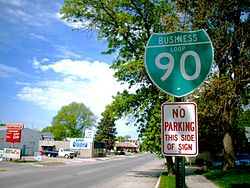
- Der Business Loop in Austin, Minnesota
- Der östliche Beginn der I-90 in Boston, Massachusetts
Siehe auch
Weblinks
Auf dieser Seite verwendete Medien
Autor/Urheber: Anthony Citrano, Lizenz: CC BY 2.5
Boston traffic is re-routed from the Ted Williams tunnel during rush hour in Boston, July 11, 2006.
Uses the Roadgeek 2005 fonts. (United States law does not permit the copyrighting of typeface designs, and the fonts are meant to be copies of a U.S. Government-produced work anyway.) Colors are from [1] (Pantone Red 187 and Blue 294), converted to RGB by [2]. The outside border has a width of 1 (1 mm) and a color of black so it shows up; in reality, signs have no outside border.
Autor/Urheber: X-Weinzar, Lizenz: CC BY-SA 3.0
Brücke über den Wanapum Lake des Interstate 90 im US-Bundesstaat Washington
Autor/Urheber: Die Autorenschaft wurde nicht in einer maschinell lesbaren Form angegeben. Es wird Jonathunder als Autor angenommen (basierend auf den Rechteinhaber-Angaben)., Lizenz: CC BY-SA 3.0
Photo I took 2006-05-20 on Interstate 90 Business Loop in Austin, Minnesota. CC & GFDL.
600 mm by 600 mm (24 in by 24 in) Interstate shield, made to the specifications of the 2004 edition of Standard Highway Signs (sign M1-1). Uses the Roadgeek 2005 fonts. (United States law does not permit the copyrighting of typeface designs, and the fonts are meant to be copies of a U.S. Government-produced work anyway.) Colors are from [1] (Pantone Red 187 and Blue 294), converted to RGB by [2]. The outside border has a width of 1 (1 mm) and a color of black so it shows up; in reality, signs have no outside border.
600 mm by 600 mm (24 in by 24 in) Interstate shield, made to the specifications of the 2004 edition of Standard Highway Signs (sign M1-1). Uses the Roadgeek 2005 fonts. (United States law does not permit the copyrighting of typeface designs, and the fonts are meant to be copies of a U.S. Government-produced work anyway.) Colors are from [1] (Pantone Red 187 and Blue 294), converted to RGB by [2]. The outside border has a width of 1 (1 mm) and a color of black so it shows up; in reality, signs have no outside border.


