Humboldt (Mondkrater)
| Humboldt | ||
|---|---|---|
 | ||
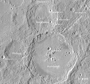
| Humboldt und Umgebung (LROC-WAC) | ||
| Position | 26,85° S, 80,76° O | |
| Durchmesser | 199 km | |
| Tiefe | 5160 m[1] | |
| Kartenblatt | 99 (PDF) | |
| Benannt nach | Wilhelm von Humboldt (1767–1835) | |
| Benannt seit | 1935 | |
| Sofern nicht anders angegeben, stammen die Angaben aus dem Eintrag in der IAU/USGS-Datenbank | ||

Humboldt ist ein mit etwa 200 Kilometer Durchmesser sehr großer Einschlagkrater am östlichen Rand der Mondvorderseite, zwischen Mare Fecunditatis im Nordosten und Mare Australe im Süden. An seinem nördlichen Rand schließt der kleinere Krater Hecataeus, an seinem westlichen Rand der Krater Phillips an. Der Kraterrand ist stark erodiert und weist Terrassierungen auf. Das Innere ist weitgehend eben mit einem Zentralberg, auf den hin radiale Strukturen verlaufen.
Vom nordöstlichen Wallrand aus verläuft die Kraterkette Catena Humboldt in nordöstlicher Richtung.
| Buchstabe | Position | Durchmesser | Link |
|---|---|---|---|
| B | 30,77° S, 83,64° O | 21 km | [1] |
| N | 26° S, 80,64° O | 14 km | [2] |
Der Krater wurde 1935 von der IAU nach dem deutschen Sprachwissenschaftler und Politiker Wilhelm von Humboldt offiziell benannt. Seinem bekannteren Bruder, dem Naturforscher Alexander von Humboldt, ist das Mare Humboldtianum gewidmet.
Weblinks
- Humboldt im Gazetteer of Planetary Nomenclature der IAU (WGPSN) / USGS
- Humboldt auf The-Moon Wiki
- Spektrum.de: Amateuraufnahmen [3]
Einzelnachweise
- ↑ John E. Westfall: Atlas of the Lunar Terminator. Cambridge University Press, Cambridge u. a. 2000, ISBN 0-521-59002-7.
Auf dieser Seite verwendete Medien
NASA lunar chart of equatorial region (latitudes 45S to 45N) 1 : 10.000.000 (LPC-1).
Craters Humboldt, Hecataeus and Philipps (detail of LRO - WAC global moon mosaic; Mercator projection)
This oblique view of the Moon was taken during the Apollo 15 mission. At the center is the Hecataeus crater, with Humboldt to the lower left and the smaller Phillips crater near the limb at bottom center. Note the dark patches on the interior floor of Humboldt. A portion of the Apollo spacecraft is visible along the center right edge of the image. This image was taken during the Apollo 15 mapping metric on revolution 71 from an altitude of 115 km. The selenographic coordinates of the image are 21.5° S, 79.5° E. The picture was reduced in size to 25%, cropped slightly, then rotated 90° counter-clockwise so that north is to the top.


