Hoye-Crest
| Hoye-Crest | ||
|---|---|---|
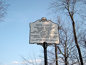
(c) Brian M. Powell, CC BY-SA 3.0 Das Gipfelkreuz am Hoye-Crest | ||
| Höhe | 1020 m | |
| Lage | Garrett County, Maryland | |
| Gebirge | Backbone Mountain, Allegheny Mountains | |
| Koordinaten | 39° 14′ 14″ N, 79° 29′ 9″ W | |
Der Hoye Crest ist mit seinen 1020 Metern der höchste Berg des Garrett County und des US-Bundesstaates Maryland. Der Berg befindet sich unweit der Grenze zu West Virginia. Auf seinem Gipfel steht eine Markierungstafel, welche genaue Informationen über die Erhebung gibt.
Weblinks
- https://www.summitpost.org/backbone-mountain/152048
- Hoye-Crest auf Peakbagger.com (englisch)
Auf dieser Seite verwendete Medien
Autor/Urheber: SANtosito, Lizenz: CC BY-SA 4.0
Relief location map of Maryland, USA
Geographic limits of the map:
- N: 40.0° N
- S: 37.6° N
- W: 79.7° W
- E: 74.8° W
(c) Brian M. Powell, CC BY-SA 3.0
Historical marker at Hoye-Crest, the high point of Maryland.
"Mount Rainier towers over all surrounding mountains, lit by the sunset and wreathed in clouds."


