Hosur
| Hosur | |||
|---|---|---|---|
| |||
| Staat: | |||
| Bundesstaat: | Tamil Nadu | ||
| Distrikt: | Krishnagiri | ||
| Lage: | 12° 44′ N, 77° 50′ O | ||
| Höhe: | 879 m | ||
| Einwohner: | 116.821 (2011) | ||
| Postleitzahl: | 635109 | ||
| Website: | http://municipality.tn.gov.in/hosur/ | ||
 | |||
Die südindische Stadt Hosur (Tamil ஓசூர்) liegt im Distrikt Krishnagiri im Bundesstaat Tamil Nadu mit ca. 120.000 Einwohnern. Sie ist vor allem als Industrieansiedlung bekannt. Gesprochen werden Tamil, Englisch, Telugu und Kannada.
Geschichte
Hosur gehörte bis 1799 zum Königreich Mysore und wurde dann durch militärische Eroberung Teil von Britisch-Indien.
Verkehr
Straßenanbindungen bestehen über den National Highway AH43 (früher NH7) in Richtung Bangalore, Chennai, Kanyakumari, Palakkad und Salem. Hosur liegt an der Bahnlinie Bengaluru-Dharmapuri-Salem der South Western Railway. Flugverbindungen gibt es vom Hosur Aerodrome (1994) aus. Der nächste Flughafen mit internationalen Verbindungen ist der etwa 80 km entfernte Kempegowda International Airport (Bengaluru Int.).
Sehenswürdigkeiten
- Hogenakkal Falls in Dharmapuri
- Rajaji Memorial (Geburtsort von C. Rajagopalachari)
- Sri Chandrachoodeshwara Temple
- Ecological Park & Walkers Lane am See Ramanaicken Lake
- Hosur Fort
Bilder
 Neue Busstation
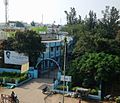 Stadtverwaltung
 Blick auf Hosur vom Chandra Choodeswarar Temple aus
 Park-Eingang am Ramanakayan Lake
 Ein Prozessionswagen
Historische Bilder des Militärmalers James Hunter (1755–1792; Royal Artillery):
 North West View of Osar by James Hunter (d.1792) (coloured in 1804)
 South East View of Osar by James Hunter (d.1792) (coloured in 1804)
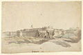 The fort of Hosur, 1792, from the south-west with breached wall and Union flag flying by James Hunter (d.1792)
Weblinks
- Hosur Municipality - Stadtverwaltung (engl.)
- Zur Geschichte von Hosur, Seite der Digital South Asia Library (engl. Hrsg. Sir William Stevenson Meyer u. a. New edition, Oxford, Clarendon Press, 1908–1931 [v. 1, 1909])
Auf dieser Seite verwendete Medien

Autor/Urheber: AshwiniKalantri, Lizenz: CC BY-SA 3.0
Location map of India with Indian claimed territories in grey. Equirectangular projection. Strechted by 106.0%. Geographic limits of the map: * N: 37.5° N * S: 5.0° N * W: 67.0° E * E: 99.0° E Made with Natural Earth. Free vector and raster map data @ naturalearthdata.com.


Plate thirty one from 'Picturesque Scenery in the Kingdom of Mysore'. Based on an original compostion by Hunter. It shows the fortified town of Hosur, which lies to the south east of Bangalore. Today Hosur is a rapidly growing industrial town which beneifts from being close to Bangalore. It held strategic importance to the British during the Mysore Wars waged against Haider Ali Khan (c.1722 - 1782) and his son, Tipu Sultan (1753 -1799), in the late Eighteenth century.
Item number: 30031

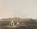
Plate nine from '24 views in Indostan by William Orme'. This picture is based on an original by Thomas Daniell (1749-1840) and depicts Hosur, a small town near to Bangalore. When this picture was made there was an encampment, represented in the distance, consisting of a detachment of Lord Cornwallis's army commanded by Major Woodburne of Madras. According to the accompnaying text, the temple on the right in the foreground was used as a resting place to 'afford cool and comfortable retreats for sun-burnt travellers.'
Plate 9.

Water-colour with pen and ink of the fort of Hosur, 1792, from the south-west with breached wall and Union flag flying by James Hunter (d. 1792). Inscribed on the reverse is: 'Oossore from reconnoitre 1792' and incorrectly below the drawing: 'Passore 1792.' See also two other views of the fort by Harraden after Hunter, plates 30 and 31, in 'Picturesque Scenery in the Kingdom of Mysore', published by Edward Orme in 1805. The incorrect inscription is a later addition and there is some overdrawing in ink, possibly by the same hand. The fort is said to have been built for Tipu Sultan by a British engineer named Hamilton, who was one of the prisoners beheaded by Tipu in 1791 on the approach of Cornwallis's army, and certainly some of the fortifications seen in the drawing are in a European rather than an Indian style. It was abandoned to the British under Major Gowdie in July 1791 and returned to Tipu after the treaty of 1792. The fort occupied a well chosen defensive site, with natural glacis on two sides, and was a massive structure with outer ramparts over 300 yards long. The southern rampart was protected by the Rama Nayakkan tank, from which the moat could be flooded. Colonel James Welsh wrote in his 'Military reminiscences,' published in 1830, 'This fort is a perfect ruin, but the fragments record its former importance; it had two entire walls of solid masonry, one within the other, and a stone counterscarp and wet ditch with two large out-works in front of the two gateways. The outer wall had many bomb-proof apartments below the ramparts, and there was a capital magazine underground; besides all this it had a square citadel in the centre, where Tipu's garrison made their last stand.' (Vol.1, p.309). Medium: Watercolour with pen and ink.

ஓசூர் பேருந்து நிலையம்

Autor/Urheber: Vijaysmileall, Lizenz: CC BY-SA 3.0
Municipality office of hosur
Autor/Urheber: Babuonwiki in der Wikipedia auf Englisch, Lizenz: CC BY-SA 3.0
Hosur Railway Station

Autor/Urheber: Ganthimathinathan, Lizenz: CC BY-SA 4.0
Ecological Park Entrance & Walkers Lane at Ramanakayan Lake


Plate 29 (thirtieth including the frontispiece) from 'Picturesque Scenery in the Kingdom of Mysore', based on a picture by James Hunter, showing the old fort at Hosur, in Tamil Nadu. Hunter served as a Lieutenant in the Royal Artillery and his sketches portrayed aspects of military and everyday life. Here we see some sepoys camped in the foreground, and in the background, a large Union Jack flying above the walled town.
Item number: 30030