City and County of Honolulu
 Rathaus „Honolulu Hale“ | |
| Verwaltung | |
|---|---|
| US-Bundesstaat: | Hawaii |
| Verwaltungssitz: | Honolulu |
| Adresse des Verwaltungssitzes: | 530 S King St Honolulu, HI 96813 |
| Gründung: | 1907 |
| Demographie | |
| Einwohner: | 1.016.508 (Stand: 2020) |
| Bevölkerungsdichte: | 654,12 Einwohner/km2 |
| Geographie | |
| Fläche gesamt: | 5509 km² |
| Wasserfläche: | 3955 km² |
| Karte | |
 | |
| Website: www.co.honolulu.hi.us | |


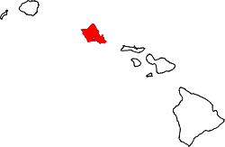
City and County of Honolulu ist ein County und gleichzeitig eine Stadt im Bundesstaat Hawaii der Vereinigten Staaten von Amerika. Es umfasst Oʻahu und die nordwestlichen Inseln des Archipels. Im County lebten im April 2020 gemäß der Volkszählung von 2020 1.016.508 Einwohner auf einer Fläche von 5509 Quadratkilometern.[1] Es entspricht statistisch der Metropolregion Honolulu.[2] Der Verwaltungssitz (County Seat) von Honolulu County ist Honolulu. Der Bürgermeister hat seinen Sitz im Honolulu Hale.
Das County wird vom Office of Management and Budget zu statistischen Zwecken als Urban Honolulu, HI Metropolitan Statistical Area geführt.[3]
Verwaltungsgliederung
Honolulu ist in neun Distrikte unterteilt. In den Distrikten sind die Census-designated places (CDP) zusammengefasst. Hawaii ist der einzige Bundesstaat in dem CDPs innerhalb einer Gemeinde definiert sind.[2]
- Distrikt I: ʻEwa, ʻEwa Beach, Honouliuli, West Loch, Kapolei, Makakilo, Kalaeloa, Honokai Hale und Nanakai Gardens, KoʻOlina, Nānākuli, Waiʻanae, Mākaha, Keaʻau, Mākua.
- Distrikt II: Mililani Mauka, Wahiawā, Whitmore Village, Mokulēʻia, Waialua, Haleʻiwa, Waimea, Pūpūkea, Sunset Beach, Kahuku, Lāʻie, Hauʻula, Punaluʻu, Kahana, Kaʻaʻawa, Kualoa, Waiāhole, Kahaluʻu, ʻĀhuimanu, Heʻeia.
- Distrikt III: Waimānalo, Kailua, Kāneʻohe.
- Distrikt IV: Hawaiʻi Kai, Kuliʻouʻou, Niu Valley, ʻĀina Haina, Wailupe, Waiʻalae-Iki, Kalani Valley, Kāhala, Wilhelmina Rise, Teile von Kapahulu, Teile von Kaimukī, Diamond Head, Waikīkī, Ala Moana.
- Distrikt V: Kapahulu, Kaimukī, Pālolo Valley, St. Louis Heights, Mānoa, Mōʻiliʻilli, McCully, Kakaʻako, Ala Moana, Makiki.
- Distrikt VI: Makiki, Honolulu (Innenstadt), Punchbowl, Liliha, Pauoa Valley, Nuʻuanu, ʻĀlewa Heights, Papakōlea, Kalihi Valley, Kalihi.
- Distrikt VII: Kalihi, Kapālama, Pālama, Iwilei, Sand Island, Māpunapuna, Airport, Hickam, Pearl Harbor, Ford Island, Āliamanu, Salt Lake, Foster Village, Stadium, Hālawa Valley Estates.
- Distrikt VIII: Fort Shafter, Moanalua, Hālawa, ʻAiea, Perl City, Seaview, Crestview, Waipiʻo Gentry.
- Distrikt IX: Waikele, Waipahu, Village Park, Kunia, Mililani.
| Davon sind: | |
|
Alle anderen Orten haben weniger als 2000 Einwohner.
Staatliche Einrichtungen
- Daniel K. Inouye International Airport
- Wheeler Army Airfield
- Kunia Camp
- Kunia Regional SIGINT Operations Center
Angrenzende Counties
- Maui County im Südosten
- Kauai County im Nordwesten
Nationalparks
- James Campbell National Wildlife Refuge
- Oʻahu Forest National Wildlife Refuge
- Papahānaumokuākea Marine National Monument
- Pearl Harbor National Wildlife Refuge
- USS Arizona Memorial
Siehe auch
Weblinks
Einzelnachweise
- ↑ 2020 Population and Housing State Data - Hawaii US Census Bureau, abgerufen am 15. August 2021 (englisch)
- ↑ a b Hawaii Geo Info. hawaii.gov (PDF-Datei, englisch).
- ↑ OMB BULLETIN NO. 20-01. Abgerufen am 26. April 2022.
Koordinaten: 21° 28′ N, 157° 58′ W
Auf dieser Seite verwendete Medien
Autor/Urheber: NordNordWest, Lizenz: CC BY-SA 3.0 de
Distrikte im Honolulu County
City seal of Honolulu, Hawaii. Image created by uploader based on an image at nava.org and other images on the web. Description: The Seal of the City and County of Honolulu is circular in shape, three inches in diameter, and designed with the tinctures added as a basis for the coat of arms as a heraldic shield quartered; first and fourth quarters bearing the stripes and colors of the Hawaiian Flag; second and third quarters, on a yellow field, a white ball pierced on a staff; overall, a green escutcheon surcharge, with a five pointed yellow star in the center.
Wide front view of Honolulu Hale, the City Hall of Honolulu, Hawaii


