Hokkaidō-Autobahn
| Hokkaidō-Autobahn in Japan | ||||||||||||||||||||||||||||||||||||||||||||||||||||||||||||||||||||||||||||||||||||||||||||||||||||||||||||||||||||||||||||||||||||||||||||||||||||||||||||||||||||||||||||||||||||||||||||||||||||||||||||||||||||||||||||
 | ||||||||||||||||||||||||||||||||||||||||||||||||||||||||||||||||||||||||||||||||||||||||||||||||||||||||||||||||||||||||||||||||||||||||||||||||||||||||||||||||||||||||||||||||||||||||||||||||||||||||||||||||||||||||||||
| Karte | ||||||||||||||||||||||||||||||||||||||||||||||||||||||||||||||||||||||||||||||||||||||||||||||||||||||||||||||||||||||||||||||||||||||||||||||||||||||||||||||||||||||||||||||||||||||||||||||||||||||||||||||||||||||||||||
| Basisdaten | ||||||||||||||||||||||||||||||||||||||||||||||||||||||||||||||||||||||||||||||||||||||||||||||||||||||||||||||||||||||||||||||||||||||||||||||||||||||||||||||||||||||||||||||||||||||||||||||||||||||||||||||||||||||||||||
| Betreiber: | NEXCO Higashi-Nihon | |||||||||||||||||||||||||||||||||||||||||||||||||||||||||||||||||||||||||||||||||||||||||||||||||||||||||||||||||||||||||||||||||||||||||||||||||||||||||||||||||||||||||||||||||||||||||||||||||||||||||||||||||||||||||||
| Straßenbeginn: | Nanae | |||||||||||||||||||||||||||||||||||||||||||||||||||||||||||||||||||||||||||||||||||||||||||||||||||||||||||||||||||||||||||||||||||||||||||||||||||||||||||||||||||||||||||||||||||||||||||||||||||||||||||||||||||||||||||
| Straßenende: | Nayoro | |||||||||||||||||||||||||||||||||||||||||||||||||||||||||||||||||||||||||||||||||||||||||||||||||||||||||||||||||||||||||||||||||||||||||||||||||||||||||||||||||||||||||||||||||||||||||||||||||||||||||||||||||||||||||||
| Gesamtlänge: | 467 km | |||||||||||||||||||||||||||||||||||||||||||||||||||||||||||||||||||||||||||||||||||||||||||||||||||||||||||||||||||||||||||||||||||||||||||||||||||||||||||||||||||||||||||||||||||||||||||||||||||||||||||||||||||||||||||
| davon in Betrieb: | 467 km | |||||||||||||||||||||||||||||||||||||||||||||||||||||||||||||||||||||||||||||||||||||||||||||||||||||||||||||||||||||||||||||||||||||||||||||||||||||||||||||||||||||||||||||||||||||||||||||||||||||||||||||||||||||||||||
 | ||||||||||||||||||||||||||||||||||||||||||||||||||||||||||||||||||||||||||||||||||||||||||||||||||||||||||||||||||||||||||||||||||||||||||||||||||||||||||||||||||||||||||||||||||||||||||||||||||||||||||||||||||||||||||||
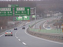
| Die Autobahn nahe Eniwa. | ||||||||||||||||||||||||||||||||||||||||||||||||||||||||||||||||||||||||||||||||||||||||||||||||||||||||||||||||||||||||||||||||||||||||||||||||||||||||||||||||||||||||||||||||||||||||||||||||||||||||||||||||||||||||||||
Straßenverlauf
| ||||||||||||||||||||||||||||||||||||||||||||||||||||||||||||||||||||||||||||||||||||||||||||||||||||||||||||||||||||||||||||||||||||||||||||||||||||||||||||||||||||||||||||||||||||||||||||||||||||||||||||||||||||||||||||
Die Hokkaidō-Autobahn bzw. Dōō-Autobahn (jap. 道央自動車道, Dōō jidōshadō, „Zentral-Hokkaidō-Autobahn“, abgekürzt 道央道, Dōō Dō, „Zentral-Hokkaidō-Straße“) ist eine Autobahn in Japan. Sie trägt seit 2017 die Nummer E5. Die Autobahn ist die Hauptverkehrsader auf der Insel Hokkaidō und besteht aus zwei Teilen, dem südlichen Teil von Nanae nach Sapporo und dem nördlichen Teil von Sapporo nach Nayoro. Diese beiden Teile haben jeweils ihre eigenen Ausfahrt-Nummerierungen. Der südliche Teil ist ca. 272 Kilometer lang, der nördliche Teil ca. 195 Kilometer, somit hat die Autobahn eine Gesamtlänge von 467 Kilometer.
Straßenbeschreibung


Nanae–Sapporo
Die Autobahn beginnt bei Nanae und läuft durch bergiges Gebiet entlang der Ostküste von Hokkaido und hat dort 2 × 2 Fahrspuren. Der erste Teil führt durch eine ländliche Gegend mit kleineren Städten. Über Yakumo folgt die Autobahn der Küste von Hokkaido. Die Hokkaidō-Autobahn hat hier auch einspurige Abschnitte mit 1×2 oder 2×1 Fahrspuren. Die Autobahn verläuft dann östlich von Muroran entlang und biegt dann nach Norden ab an Tomakomai vorbei ins Landesinnere und führt dann direkt nach Sapporo. Dieser Teil der Autobahn führt durch Waldgebiet und führt an mehreren Städten südlich von Sapporo vorbei. Dann führt die Autobahn durch den östlichen Teil der Stadt Sapporo und endet an einem Kreuz mit der Sasson-Autobahn.
Sapporo–Nayoro
Der nördliche Teil beginnt am Autobahnkreuz, wo der südliche geendet hat. Die Autobahn verläuft östlich von Sapporo. Die Autobahn hat hier 2×2 Fahrspuren und biegt später nach Norden, durch ein verengtes Tal mit mehreren mittelgroßen Städten auf der Strecke, und es werden mehrere Flüsse überquert. Weiter im Norden ist die Landschaft hügelig und es folgen einige Tunnel. Die Autobahn steigt auf etwa 250 Meter über dem Meeresspiegel. Die wichtigste Stadt in diesem Bereich ist Asahikawa. Kurz danach endet die Autobahn.
Geschichte
Die Autobahn ist seit den 70er Jahren gebaut worden. Im Jahr 1971 eröffnete der erste Abschnitt zwischen Kitahiroshima und Chitose für den Verkehr, der 1972 auf vier Fahrspuren erweitert wurde. Im Jahr 1978 folgte der Teil um Tomakomai und im Jahr 1979 der Teil zwischen Sapporo und Kitahiroshima. In den 80er Jahren wurde die Autobahn sowohl nach Süden als auch nach Norden aus der Region Sapporo erweitert. 1990 erreichte die Autobahn die Stadt Asahikawa im Norden, und 1991 erreichte sie die Stadt Muroran im Süden. Zwischen 1992 und 1997 wurde die Straße nach Westen erweitert bis nach Oshamanbe. Im Jahr 2000 wurde der nördliche Teil bis Wassamu erweitert und 2003 mit dem aktuellen Ende bei Shibetsu ausgebaut. Zwischen 2006 und 2009 wurde vor allem im Süden von Hokkaido gebaut, und die Autobahn erreichte Otoshibe in Yakumo.
Eröffnungsdaten der Autobahn
| von | nach | Länge | Datum |
|---|---|---|---|
| Kitahiroshima | Chitose | 23 km | 04.12.1971 |
| Chitose | Tomakomai-higashi | 12 km | 24.10.1978 |
| Sapporo-minami | Kitahiroshima | 5 km | 29.10.1979 |
| Tomakomai-higashi | Tomakomai-nishi | 17 km | 29.10.1980 |
| Sapporo | Iwamizawa | 32 km | 09.11.1983 |
| Tomakomai-nishi | Shiraoi | 15 km | 30.11.1983 |
| Shiraoi | Noboribetsu-higashi | 19 km | 18.10.1985 |
| Sapporo | Sapporo-minami | 8 km | 25.10.1985 |
| Noboribetsu-higashi | Noboribetsu Muroran | 11 km | 09.10.1986 |
| Iwamizawa | Bibai | 22 km | 18.08.1987 |
| Bibai | Takikawa | 27 km | 08.10.1988 |
| Takikawa | Fukagawa | 18 km | 12.09.1989 |
| Fukagawa | Ashikawa Takasu | 27 km | 30.10.1990 |
| Noboribetsu Muroran | Muroran | 10 km | 25.10.1991 |
| Muroran | Date | 13 km | 27.10.1992 |
| Date | Abuta Toyako | 13 km | 30.03.1994 |
| Abuta Toyako | Oshamanbe | 47 km | 22.10.1997 |
| Asahikawa Takasu | Wassamu | 30 km | 04.10.2000 |
| Oshamanbe | Kunnui | 11 km | 19.11.2001 |
| Wassamu | Shibetsu-Kenbuchi | 16 km | 04.10.2003 |
| Kunnui | Yakumo | 22 km | 18.11.2006 |
| Yakumo | Otoshibe | 16 km | 10.10.2009 |
| Otoshibe | Mori | 20 km | 26.11.2011 |
| Mori | Kayabe | 10 km | 10.11.2012 |
Zukunft
Zwischen Kayabe und Nanae fehlt noch ein Stück der Autobahn, das jedoch durch die Nationalstraße 5 bedient wird. Dieser ist bereits teilweise vierspurig und mit einigen Kreuzungen vor allem bei der Umgehung von Nanae ausgebaut.
Verkehrsaufkommen
Im Jahr 2003 fuhren ca. 9.400 Fahrzeuge täglich über den südlichen Teil der Autobahn, mit einem Anstieg auf ca. 26.000 Fahrzeuge im Süden von Sapporo. Die meisten Fahrzeuge benutzen die Autobahn bei Kitahiroshima mit 31.000 Fahrzeugen pro Tag. Der nördlichste Teil bei Asahikawa hat nur 1.600 Fahrzeuge pro Tag.
Ausbau der Fahrbahnen
| von | nach | Länge | Fahrspuren |
|---|---|---|---|
| Onumakoen | Noboribetsu Muroran | 160 km | 1×1 |
| Noboribetsu Muroran | Asahikawa Takasu | 235 km | 2×2 |
| Asahikawa Takasu | Shibetsu Kenbuchi | 70 km | 1×1 |
Weblinks
- Betreibergesellschaft Higashi-Nihon Kōsokudōro K.K. (japanisch)
- Hokkaido_Expressway_(Japan) Wegenwiki (niederländisch)
Auf dieser Seite verwendete Medien
Zeichen 391 – Mautpflichtige Strecke, StVO 2003. Farblich korrekte Umsetzung der Originalvorlage mit dem digitalen RAL-Farbton „Verkehrsrot“. Im Verkehrsblatt, Heft 24, 1976, Seite 786, wird das Zeichen „Zollstelle“, aus dem Zeichen 391 abgeleitet wurde, in seinen Details abgebildet. Die Gesamtgröße beträgt in der Regel 600 x 600 mm, in Ausnahmefälle ist eine andere Größe möglich. Die Lichtkantenbreite beträgt 10 mm, der rote Rahmen ist 24 mm breit. Die Versalhöhe beträgt bei Zeichen 391 insgesamt 100 mm. Der Ausrundungshalbmesser am linken und rechten Ende des schwarzen Balkens beträgt 50 mm.
深川JCT(道央道を旭川方面)
This is a diagram of Japanese National Route Sign. The glyphs of 国道 are the outline path from free font that is "NARAYAMA Maru Gothic" created by excl-zoo, based on "Wadalab Hosomaru Gothic". If you want to change the glyphs, you MUST check the license of substitute glyphs/fonts.
ja: 日本の国道標識。「国道」のグリフは「和田研細丸ゴシック」を種字とし excl-zoo が作成した「ならやま丸ゴシック」のアウトラインパスである。もし、「国道」のグリフを変更する場合は、変更に使用するフォントのライセンスを確認すること。特にグリフをアウトライン化して埋め込む場合、多くのフォントは商用利用に制限が存在する。
This is a diagram of Asahikawa-Monbetsu Expwy route sign.This image's Japanese glyphs are the outline path from free font that is "VL Gothic"(Substitute of the Hiragino).English glyphs are the outline path from free font that is "GD-HighwayGothicJA(pumpCurry)". If you want to change the English glyphs, you MUST check the license of substitute glyphs/fonts.
This is a diagram of Japanese National Route Sign. The glyphs of 国道 are the outline path from free font that is "NARAYAMA Maru Gothic" created by excl-zoo, based on "Wadalab Hosomaru Gothic". If you want to change the glyphs, you MUST check the license of substitute glyphs/fonts.
ja: 日本の国道標識。「国道」のグリフは「和田研細丸ゴシック」を種字とし excl-zoo が作成した「ならやま丸ゴシック」のアウトラインパスである。もし、「国道」のグリフを変更する場合は、変更に使用するフォントのライセンスを確認すること。特にグリフをアウトライン化して埋め込む場合、多くのフォントは商用利用に制限が存在する。
This is a diagram of Dōtō Expwy route sign. This image's glyphs are the outline path from free font that is "GD-HighwayGothicJA(pumpCurry)". If you want to change the glyphs, you MUST check the license of substitute glyphs/fonts.
This is a diagram of Fukagawa-Rumoi Expwy route sign.This image's Japanese glyphs are the outline path from free font that is "VL Gothic"(Substitute of the Hiragino).English glyphs are the outline path from free font that is "GD-HighwayGothicJA(pumpCurry)". If you want to change the English glyphs, you MUST check the license of substitute glyphs/fonts.
Motorway Exit Icon in green for left-hand driving areas
This is a diagram of Dōō Expressway route sign. This image's glyphs are the outline path from free font that is "GD-HighwayGothicJA(pumpCurry)". If you want to change the glyphs, you MUST check the license of substitute glyphs/fonts.
This is a diagram of Japanese National Route Sign. The glyphs of 国道 are the outline path from free font that is "NARAYAMA Maru Gothic" created by excl-zoo, based on "Wadalab Hosomaru Gothic". If you want to change the glyphs, you MUST check the license of substitute glyphs/fonts.
ja: 日本の国道標識。「国道」のグリフは「和田研細丸ゴシック」を種字とし excl-zoo が作成した「ならやま丸ゴシック」のアウトラインパスである。もし、「国道」のグリフを変更する場合は、変更に使用するフォントのライセンスを確認すること。特にグリフをアウトライン化して埋め込む場合、多くのフォントは商用利用に制限が存在する。
This is a diagram of Sasson Expressway route sign. This image's glyphs are the outline path from free font that is "GD-HighwayGothicJA(pumpCurry)". If you want to change the glyphs, you MUST check the license of substitute glyphs/fonts.
This is a diagram of Japanese National Route Sign. The glyphs of 国道 are the outline path from free font that is "NARAYAMA Maru Gothic" created by excl-zoo, based on "Wadalab Hosomaru Gothic". If you want to change the glyphs, you MUST check the license of substitute glyphs/fonts.
ja: 日本の国道標識。「国道」のグリフは「和田研細丸ゴシック」を種字とし excl-zoo が作成した「ならやま丸ゴシック」のアウトラインパスである。もし、「国道」のグリフを変更する場合は、変更に使用するフォントのライセンスを確認すること。特にグリフをアウトライン化して埋め込む場合、多くのフォントは商用利用に制限が存在する。
This is a diagram of Hidaka Expwy route sign.This image's Japanese glyphs are the outline path from free font that is "VL Gothic"(Substitute of the Hiragino).English glyphs are the outline path from free font that is "GD-HighwayGothicJA(pumpCurry)". If you want to change the English glyphs, you MUST check the license of substitute glyphs/fonts.
This is a diagram of Japanese National Route Sign. The glyphs of 国道 are the outline path from free font that is "NARAYAMA Maru Gothic" created by excl-zoo, based on "Wadalab Hosomaru Gothic". If you want to change the glyphs, you MUST check the license of substitute glyphs/fonts.
ja: 日本の国道標識。「国道」のグリフは「和田研細丸ゴシック」を種字とし excl-zoo が作成した「ならやま丸ゴシック」のアウトラインパスである。もし、「国道」のグリフを変更する場合は、変更に使用するフォントのライセンスを確認すること。特にグリフをアウトライン化して埋め込む場合、多くのフォントは商用利用に制限が存在する。


