Hill Station

Hill Station bezeichnet von höheren Militärs und Zivilbeamten in Britisch-Indien und in anderen Teilen des britischen Kolonialreiches eingerichtete und genutzte Orte, die während der heißen Sommermonate als Rückzugsorte dienten.
Lage
Hill Stations wurden aus klimatischen und gesundheitlichen Gründen meist in waldreichen Gegenden und in Höhen über 1000 oder sogar über 1500 m eingerichtet[1]; es gibt aber auch einige wenige – meist in Küstennähe befindliche – sogenannte Hill Stations mit einer Höhe von unter 100 m (z. B. Manipal).
Tourismus
Viele Hill Stations verfügten über Sanatoriums- und Kureinrichtungen; die meisten wurden von der Britischen Armee initiiert und genutzt. Einige dieser Orte wurden bereits vor den Briten von den regionalen Maharajas oder den in Delhi und Agra residierenden Mogul-Herrschern und ihrem Hofstaat aufgesucht. Viele ehemalige Hill Stations spielen heute eine wichtige Rolle für den regionalen, teilweise sogar für den überregionalen Tourismus. Einige wurden ganz oder teilweise in Naturschutzgebiete integriert bzw. in solche umgewandelt (z. B. die Biligiriranga Hills, Nagarhole oder Pachmarhi).
Liste der Hill Stations in Indien
|
|
|
|
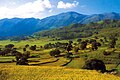 Landschaft im Araku Valley, Andhra Pradesh
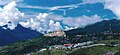
 Berglandschaft bei Dharamsala, Himachal Pradesh
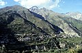 Landschaft bei Keylong, Himachal Pradesh
 Khajjiar, Himachal Pradesh
 Biligiriranga Hills, Karnataka

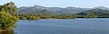
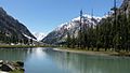 Mahodand-Lake im Kalam-Tal, Pakistan
 Matiltan im Kalam-Tal, Pakistan
Liste der Hill Stations in Pakistan

|
|
|
Literatur
Weblinks
- 52 Hill Stations in Indien – Fotos + Infos (englisch)
- 80 Hill Stations in Indien – Fotos + Infos (englisch)
Einzelnachweise und Anmerkungen
- ↑ Zeitschrift für Wirtschaftsgeographie: Sozialgeographie unter Berücksichtigung der Handels- und Verkehrsgeographie, Band 17, Pick-Verlag, 1973, S. 41
Auf dieser Seite verwendete Medien


Autor/Urheber: Muh.Ashar, Lizenz: CC BY-SA 3.0
Matilton Village is a beautiful village in Swat, KPK on the way to Mahodand Lake.
Autor/Urheber: Shahzaib Damn Cruze, Lizenz: CC BY-SA 4.0
Ahhh! i envy those Teeny Tinny Hobbit like houses & People who live in such sereny!
Facts 1. Meaning (marī, "apex") is a mountain resort town. 2. Located in the Galyat region of the Pir Panjal Range, within the Rawalpindi District of Punjab, Pakistan. 3. It has average altitude of 2,291 metres (7,516 ft). 4. Founded in 1851 as a sanatorium (medical treatment) for British troops by President of the Punjab Administrative Board, Sir Henry Lawrence. The permanent town of Murree was constructed in 1853 and the church was sanctified shortly thereafter. 5. Murree was the summer headquarters of the colonial Punjab Government until 1876 when it was moved to Shimla. 6. Since the Independence of Pakistan in 1947, Murree has retained its position as a popular hill station, noted for its pleasant summers.
7. Murree or Marhee as it was then called, was first identified as a potential hill station by Major James Abbott (Indian Army officer) in 1847.
Autor/Urheber: KennyOMG, Lizenz: CC BY-SA 3.0
Blick auf Dal Lake und die Stadt Srinagar vom Shankaracharya Hügel aus

Autor/Urheber: Arjun Singh Kulkarni, Lizenz: CC BY-SA 2.0
Lonavala Hill station, India

Das Städtchen Tawang im gleichnamigen nordindischen Distrikt

Araku-valley

Autor/Urheber: Planemad, Lizenz: CC BY-SA 3.0
Panoramic view of a en:Gaddi mountain hut overlooking the Dhauladhar range of the Himalayas and Dharamshala town. For travel details see wikivoyage:Sidhbari

Autor/Urheber: Asif Shahzad, Lizenz: CC BY-SA 3.0
Mahodand Lake is located in Kalam Area of Swatvalley and it can be access via Jeed or four wheel vehicle. Very cool and sound area from the northern pakistan.if some need to stay there for a night or more so he should camp there because hotel nearby the lake. The area is lush green with very cold water.
Autor/Urheber: SriniG, Lizenz: CC BY-SA 3.0
A summer afternoon at Khajjiar, Himachal Pradesh, India

Autor/Urheber: Prashanthns, Lizenz: CC BY-SA 3.0
A view of the Biligirangan Hills range as seen from the Krishnayyana Katte reservoir at the foothills near the northern edge of the BR Hills Wildlife Sanctuary, just before the Gumballi checkpost. Photo shows a part of the reservoir and the North-South range with dry deciduous forest in late winter.

Autor/Urheber: Peter Krimbacher Moebius1,, Lizenz: CC BY-SA 4.0
Kyelang, Distrikthauptstadt von Lahaul und Spiti, Himachal Pradesh, Indien

Autor/Urheber: Bimal K C from Cochin, India, Lizenz: CC BY 2.0
Taken from Munnar , Kerala
One of the most popular hill stations in India, Munnar (Kerala) is situated at the confluence of three mountain streams - Mudrapuzha, Nallathanni and Kundala. Located at 1600 M above sea level, this was once the summer resort of the erstwhile British Government in South India. Sprawling tea plantations, picture book towns, winding lanes, trekking and holiday facilities make Munnar a unique experience. Munnar is essentially a tea town.