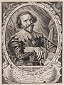
Henricus Hondius
Henricus Hondius II., auch Hendrik Hondius der Jüngere (* 1597 in Amsterdam; † 16. August 1651 ebenda), war ein niederländischer Kupferstecher, Kartograf und Verleger.
Leben
Hondius war der Sohn des berühmten Kartographen Jodocus Hondius, der in Amsterdam ein kartographisches Unternehmen gegründet hatte.[1] Nachdem Hendrik zunächst im elterlichen Betrieb mitgearbeitet hatte, gründete er 1621 in seiner Heimatstadt einen eigenen Verlag. 1633 ging Henricus eine Partnerschaft mit dem Kartographen und seinem Schwager Johannes Janssonius ein, und gemeinsam führten sie das Geschäft weiter. 1641 gab er eine neue Auflage des Mercator-Hondius-Atlas mit veränderten Hondius-Karten heraus[2].
Werke
- Gerhard Mercator: Vom Zürichgow. Henricus Hondius, Amsterdam 1633 (Digitalisat).

1622 Oostelijk Zeeuws Vlaanderen

Saxoniae superioris Lusatiae Misniaeque descriptio, Karte aus dem Mercator-Hondius-Atlas von 1627

1630 Weltkarte, Nova Totius Terrarum Orbis Geographica ac Hydrographica Tabula

1631 Afrika

1636 Nordamerika

1641 Karte der Schlösser in der Umgebung von Ypern, Belgien
Pieter van den Broecke

Dänemark 17. Jahrhundert
Literatur
- Nadine Orenstein, Hendrick Hondius and the Business of Prints in Seventeenth-century Holland. Sound & Vision Interactive, 1996, ISBN 90-75607-04-0.
- Joseph Eduard Wessely: Hondius. In: Allgemeine Deutsche Biographie (ADB). Band 13, Duncker & Humblot, Leipzig 1881, S. 69 f.
Weblinks
Einzelnachweise
- ↑ Venezuela with the Southern Part of New Andalusia. In: loc.gov. Abgerufen am 8. Juli 2022.
- ↑ Maps of World: Henricus Hondius (Memento vom 11. April 2009 im Internet Archive).
| Personendaten | |
|---|---|
| NAME | Hondius, Henricus |
| ALTERNATIVNAMEN | Hondt, Hendrik de; Hondius, Hendrik der Jüngere |
| KURZBESCHREIBUNG | niederländischer Kartograf und Verleger |
| GEBURTSDATUM | 1597 |
| GEBURTSORT | Amsterdam |
| STERBEDATUM | 16. August 1651 |
| STERBEORT | Amsterdam |
Auf dieser Seite verwendete Medien

Kaart van de kastelen in de omgeving van Ieper, België

_balanced.jpg)
This is an image of Nova totius Terrarum Orbis geographica ac hydrographica tabula, a map of the world created by Hendrik Hondius in 1630, and published the following year in the atlas Atlantis Maioris Appendix.
Among its claims to notability is the fact that it was the first dated map published in an atlas, and therefore the first widely available map, to show any part of Australia, the only previous map to do so being Hessel Gerritsz' 1627 Caert van't Landt van d'Eendracht ("Chart of the Land of Eendracht"), which was not widely distributed.
The Australian coastline shown is part of the west coast of Cape York Peninsula, discovered by Jan Carstensz in 1623. Curiously, the map does not show the west coast features shown in Gerritsz' Caert.
This famous Dutch map exhibits the general state of European knowledge (and ignorance) about North America at the time of its first publication in 1636. Much of the hard earned knowledge came from danger filled explorations funded by various chartered companies. The map shows Hudson's Bay, reflecting knowledge of the results of Hudson's last fatal voyage of 1610 under the auspices of the English Virginia and East India Companies. Nearby Button's Bay was named for Welshman Thomas Button who had explored it in 1612 while seeking to determine what happened to Hudson and his followers who had been cast adrift by mutineers the year before. The Company of the Merchants Discoverers of the North-West Passage, or Northwest Company, funded Button's voyage. Dutch knowledge of his discovery and the depiction of California as an island probably came from Englishman Henry Brigg's map The North Part of America, published 1625 in Samuel Purchas' compendium of travel accounts titled Purchas, His Pilgrims. "Lac de Champlain" and the extension of the St. Lawrence to "Lac des Iroquois" (Lake Ontario) provide evidence of Champlain's extensive explorations associated with French companies granted monopolies on fur trading and colonization.

17de Eeuwse kaart van het westelijk gedeelte van Zeeuws Vlaanderen

Autor/Urheber: Bairuilong, Lizenz: CC BY-SA 4.0
17th-century maps of Denmark. Cartographer: Gerard Mercator. Produced by Henricus Hondius.
.jpg)
- Africæ nova tabula
- Nouvelle Afrique

Pieter van den Broecke