Hardy Cove
| Hardy Cove | ||
|---|---|---|
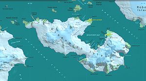
 Karte von Greenwich Island mit der Hardy Cove (rechts) | ||
| Gewässer | Bransfieldstraße | |
| Landmasse | Greenwich Island, Südliche Shetlandinseln | |
| Geographische Lage | 62° 31′ 6,6″ S, 59° 35′ 35,52″ W | |
Die Hardy Cove ist eine Bucht an der Ostküste von Greenwich Island im Archipel der Südlichen Shetlandinseln.
Der britische Robbenjäger Robert Fildes (1793–1827), der zwischen 1820 und 1822 in den Gewässern um die Südlichen Shetlandinseln operierte, benannte die heute als Sartorius Point bekannte Landspitze als Hardy Point. Um Fildes’ Benennung zu bewahren, übertrug sie das UK Antarctic Place-Names Committee im Jahr 1961 auf die hier beschriebene Bucht. Namensgeber ist der britische Admiral Thomas Masterman Hardy (1769–1839).
Weblinks
- Hardy Cove. In: Geographic Names Information System. United States Geological Survey, United States Department of the Interior, archiviert vom (englisch).
- Hardy Cove auf geographic.org (englisch)
Auf dieser Seite verwendete Medien
Autor/Urheber: NordNordWest, Lizenz: CC BY-SA 3.0
Positionskarte der Südlichen Shetlandinseln
Autor/Urheber: Antarctic Place-names Commission of Bulgaria, Lizenz: GPL
L.L. Ivanov et al., Antarctica: Livingston Island, South Shetland Islands (from English Strait to Morton Strait, with illustrations and ice-cover distribution), 1:100000 scale topographic map, Antarctic Place-names Commission of Bulgaria, Sofia, 2005 (Fragment) Fragment released in the public domain by the Antarctic Place-names Commission of Bulgaria.


