Hall Rock
| Hall Rock | ||
|---|---|---|
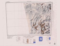
 Topographische Karte mit dem Hall Rock (südwestlicher Kartenquadrant) | ||
| Lage | Viktorialand, Ostantarktika | |
| Gebirge | Transantarktisches Gebirge | |
| Koordinaten | 76° 51′ 0″ S, 159° 20′ 0″ O | |
Der Hall Rock ist eine große Felsformation im ostantarktischen Viktorialand. Der Felsen ragt 3 km nordwestlich der Carapace-Nunataks am Rand des Polarplateaus auf.
Das Advisory Committee on Antarctic Names benannte ihn 1971 nach dem Geologen Bradford Allyn Hall (1933–2016) von der University of Maine, der zwischen 1968 und 1969 an der Erforschung des sogenannten Mawson-Tillits in der Umgebung dieses Felsens beteiligt war.
Weblinks
- Hall Rock. In: Geographic Names Information System. United States Geological Survey, United States Department of the Interior, archiviert vom (englisch).
- Hall Rock auf geographic.org (englisch)
Auf dieser Seite verwendete Medien
Autor/Urheber: Alexrk2, Lizenz: CC BY-SA 3.0
Physische Positionskarte Antarktis, Mittabstandstreue Azimutalprojektion
1:250,000-scale topographic reconnaissance map of the Convoy Range area from 156°-162'E to 76°-77°S in Antarctica. Mapped, edited and published by the U.S. Geological Survey in cooperation with the National Science Foundation.


