Greenwich Island
| Greenwich Island | ||
|---|---|---|
 | ||
| Gewässer | Südlicher Ozean | |
| Inselgruppe | Südliche Shetlandinseln | |
| Geographische Lage | 62° 31′ S, 59° 47′ W | |
| ||
| Länge | 24 km | |
| Breite | 10 km | |
| Fläche | 173,8 km² | |
| Höchste Erhebung | Momchil Peak 625 m | |
| Einwohner | 9 Stationspersonal im Winter <1 Einw./km² | |
| Hauptort | (Arturo-Prat-Station) | |
 | ||
Greenwich Island (historische Namen: Sartorius Island, Berezina Island) ist eine Insel der Südlichen Shetlandinseln. Sie hat eine Länge von 24 km, eine Breite zwischen 0,8 und 10 km und weist eine Fläche von 173,8 km² auf.[1] Sie liegt in der Südgruppe des Archipels zwischen Robert Island im Nordosten und Livingston Island im Südwesten und wird von diesen getrennt durch die Englische und die McFarlane-Straße. Die höchste Erhebung der stark vergletscherten Insel ist der 625 m hohe Momchil Peak.
Die chilenische Forschungsstation Arturo Prat und die ecuadorianische Station Pedro Vicente Maldonado liegen an der Discovery Bay im Nordosten der Insel.
Die Bezeichnung Greenwich Island datiert zurück auf das Jahr 1821 oder noch früher und hat sich als gängiger Name der Insel durchgesetzt.
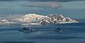

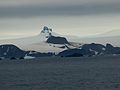 Chrabr-Nunatak
 Arturo-Prat-Station
Karten

- L. L. Ivanov et al.: Antarctica: Livingston Island and Greenwich Island, South Shetland Islands (from English Strait to Morton Strait, with illustrations and ice-cover distribution). Topografische Karte im Maßstab 1:100.000, Antarctic Place-names Commission of Bulgaria, Sofia 2005.
- L. L. Ivanov: Antarctica: Livingston Island and Greenwich, Robert, Snow and Smith Islands. Topografische Karte im Maßstab 1:120.000. Manfred-Wörner-Stiftung, Troyan, 2009. ISBN 978-954-92032-6-4
Weblinks
Einzelnachweise
- ↑ UNEP Islands ( des vom 1. Mai 2013 im Internet Archive) Info: Der Archivlink wurde automatisch eingesetzt und noch nicht geprüft. Bitte prüfe Original- und Archivlink gemäß Anleitung und entferne dann diesen Hinweis. (englisch)
Auf dieser Seite verwendete Medien

Autor/Urheber: Der ursprünglich hochladende Benutzer war Apcbg in der Wikipedia auf Englisch, Lizenz: CC BY-SA 3.0
Hrabar Nunatak from English Strait, with Sharp Peak, Livingston Island in the background.

Autor/Urheber: Arne Granfoss, Lizenz: CC BY-SA 3.0
St. Kiprian Peak in Greenwich Island, Antarctica

La base chilena Arturo Prat. Ubicada en Puerto Soberanía, isla Greenwich. El perro es Estopin del patrullero Lientur

Autor/Urheber: NordNordWest, Lizenz: CC BY-SA 3.0
Positionskarte der Südlichen Shetlandinseln

Autor/Urheber: Antarctic Place-names Commission of Bulgaria, Lizenz: GPL
L.L. Ivanov et al., Antarctica: Livingston Island, South Shetland Islands (from English Strait to Morton Strait, with illustrations and ice-cover distribution), 1:100000 scale topographic map, Antarctic Place-names Commission of Bulgaria, Sofia, 2005 (Fragment) Fragment released in the public domain by the Antarctic Place-names Commission of Bulgaria.
Autor/Urheber: Apcbg, Lizenz: CC BY-SA 4.0
L.L. Ivanov. Antarctica: Livingston Island and Greenwich, Robert, Snow and Smith Islands. Scale 1:120000 topographic map. Troyan: Manfred Wörner Foundation, 2010. ISBN 978-954-92032-9-5 (First edition 2009. ISBN 978-954-92032-6-4)