Grand Canyon West
| Grand Canyon West | ||
|---|---|---|
 | ||
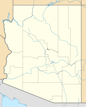
| Lage in Arizona | ||
| Basisdaten | ||
| Staat: | Vereinigte Staaten | |
| Bundesstaat: | Arizona | |
| County: | Mohave County | |
| Koordinaten: | 35° 35′ N, 113° 29′ W | |
| Zeitzone: | Mountain Standard Time (UTC−7) | |
| Einwohner: | 0 (Stand: 2020) | |
| Haushalte: | 0 (Stand: 2020) | |
| Fläche: | 45,58 km² (ca. 18 mi²) | |
| Bevölkerungsdichte: | 0 Einwohner je km² | |
| Höhe: | 1444 m | |
| FIPS: | 04-28985 | |
| GNIS-ID: | 2582791 | |
| Website: | grandcanyonwest.com | |
Grand Canyon West ist ein Ort (Census-designated place) im Mohave County in Arizona, USA. Der Ort ist insbesondere für seinen touristischen Erlebnispark am Grand Canyon, welcher westlich außerhalb des Grand-Canyon-Nationalparks gelegen ist, bekannt. Zum United States Census 2020 befanden sich noch zehn permanente Wohnungen in dem Ort, es lebten allerdings keine permanenten Einwohner mehr in Grand Canyon West.[1]
Der Ort gehört zum Stammesgebiet der Hualapai-Indianer und wird von diesen auch teilautonom verwaltet.
Erlebnispark
In Grand Canyon West befindet sich ein gleichnamiger touristischer Erlebnispark am Grand Canyon. Seit dem Frühjahr 2007 ist die Hauptattraktion von Grand Canyon West der Grand Canyon Skywalk, eine über den Rand des Canyons hinausragende Plattform aus Stahl und Glas. Gegenüber befindet sich der Eagle Point, eine Felsformation, die aus den Tiefen des Canyons aufragt und der Form eines Adlers mit gestreckten Flügeln gleicht. Der Eagle Point stellt ein wichtiges Heiligtum für die Hualapai-Indianer dar und wird von diesen in Zeremonien verehrt.
Ein weiterer beliebter Aussichtspunkt ist Guano Point, 3 Kilometer nördlich. Von hier ist ein Rundumblick auf das westliche Gebiet des Grand Canyons möglich.
Die touristischen Angebote umfassen Rekonstruktionen von Hütten und Zelten fünf verschiedener Indianer-Kulturen und eine Ranch des Wilden Westens mit Living-History-Veranstaltungen.
Sowohl der Zugang zum Gebiet als auch die einzelnen Angebote sind jeweils kostenpflichtig.
Weblinks
- Offizielle Website (englisch)
Einzelnachweise
- ↑ Explore Census Data Grand Canyon West CDP, Arizona. Abgerufen am 22. Oktober 2022.
Auf dieser Seite verwendete Medien
Autor/Urheber: Balazs Barnucz, Lizenz: CC BY-SA 3.0
Ausblick auf das westliche Gebiet des Grand Canyons vom Guano Point aus
Autor/Urheber: NordNordWest, Lizenz: CC BY-SA 3.0
Positionskarte von Arizona, USA


