Graham-Küste
| Graham-Küste | |
|---|---|
 Sentinel-2-Aufnahme der Graham-Küste | |
 | |
| Lage | Antarktische Halbinsel, Westantarktika |
| Gewässer | Südlicher Ozean |
| Von | Kap Renard 65° 1′ 16″ S, 63° 45′ 50,8″ W |
| Bis | Kap Bellue 66° 18′ 2,9″ S, 65° 53′ 16,1″ W |
Koordinaten: 66° S, 64° W
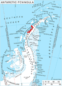
Die Graham-Küste ist ein Küstenabschnitt im Westen der Antarktischen Halbinsel, der zwischen dem Kap Renard und dem Kap Bellue im Grahamland liegt. Nördlich schließt sich die Danco-Küste an, südlich die Loubet-Küste.
Benannt ist sie nach James Robert George Graham (1792–1862), Erster Lord der britischen Admiralität zu der Zeit, als John Biscoe 1832 den Westen der Antarktischen Halbinsel erkundete.
Weblinks
- Graham Coast. In: Geographic Names Information System. United States Geological Survey, United States Department of the Interior, archiviert vom (englisch).
- Graham Coast auf geographic.org (englisch)
Auf dieser Seite verwendete Medien
The icy landscape of Graham Coast, which lies on the west side of the Antarctic Peninsula, is featured in this Copernicus Sentinel-2 image taken in December 2022.
Zoom in to explore this image at its full resolution.
The Antarctic Peninsula is the northernmost and warmest region of the Antarctic continent. It resembles a 1000-km-long arm, stretching towards the southern tip of South America. The west coast of the peninsula is home to over 100 large glaciers, some of which are visible in this image; from the right: Murphy, Wilkinson, Drummond, Erskine, Widmark, Hugi, Lawrie, Weir and Comrie.
Like many places on Earth, the region has experienced exceptional atmospheric warming over the last decades. Using satellite data, a team of scientists have measured the speed of glaciers on the and discovered that in the summer months they are flowing faster than expected.
While some ice melts into the ocean, some breaks off into icebergs. The dark colour of the waters in the image allows us to easily spot many icebergs floating along the coast, as well as fragmented sea ice.
The Biscoe Islands also lie off the coast. The bigger islands visible in the image are the 45-km long Renaud Island on the left and the 29-km long Lavoisier Island in the centre.
The Copernicus Sentinel-2 satellites each carry a high-resolution camera that takes images of Earth’s surface. While there are many advantages to this type of optical instrument, they cannot acquire meaningful images when it is dark or very cloudy. However, Sentinel-2’s wide swath and frequent revisit times increase the chance of imaging when the clouds part, as we see here in this image.
Autor/Urheber: Edited by Apcbg, Lizenz: CC BY 3.0
Location of Graham Coast, Antarctica.

