Governor Mountain
| Governor Mountain | ||
|---|---|---|
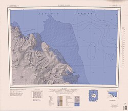
 Topografische Karte des Gebiets um den Suworow-Gletscher mit dem Governor Mountain (links) | ||
| Höhe | 1550 m | |
| Lage | Viktorialand, Ostantarktika | |
| Gebirge | Wilson Hills, Transantarktisches Gebirge | |
| Koordinaten | 69° 42′ 50″ S, 158° 42′ 34″ O | |
Der Governor Mountain ist ein 1550 m hoher, größtenteils eisfreier Berg an der Oates-Küste des ostantarktischen Viktorialands. Er ragt an der Westflanke des Entstehungsgebiets des Tomilin-Gletschers in den Wilson Hills auf.
Das Gebiet wurde durch Vermessungsarbeiten des United States Geological Survey von 1962 bis 1963 kartografisch erfasst. Der Berg diente als Vermessungsstation für die Nordgruppe einer von 1963 bis 1964 durchgeführten Kampagne im Rahmen der New Zealand Geological Survey Antarctic Expedition, die ihn nach Bernard Fergusson, Baron Ballantrae (1911–1980) benannte, dem von 1962 bis 1967 amtierenden Generalgouverneur (englisch Governor General) von Neuseeland.
Weblinks
- Governor Mountain. (ZIP; 1,76 MB) In: Geographic Names Information System. United States Geological Survey (englisch). (englisch)
- Governor Mountain auf geographic.org (englisch)
Auf dieser Seite verwendete Medien
1:250,000-scale topographic reconnaissance map of the Suvorov Glacier area from 158°-162°E to 69°-70°S in Antarctica. Mapped, edited and published by the U.S. Geological Survey in cooperation with the National Science Foundation.
Autor/Urheber: Alexrk2, Lizenz: CC BY-SA 3.0
Physische Positionskarte Antarktis, Mittabstandstreue Azimutalprojektion


