Gorontalo (Stadt)
| Kota Gorontalo Gorontalo | |||
|---|---|---|---|
| Koordinaten | 0° 32′ 0″ N, 123° 4′ 0″ O | ||
| Symbole | |||
| |||
| Basisdaten | |||
| Staat | Indonesien | ||
| Geographische Einheit | Sulawesi | ||
| Provinz | Gorontalo | ||
| ISO 3166-2 | ID-GO | ||
| Fläche | 79,6 km² | ||
| Einwohner | 153.036 (2005) | ||
| Dichte | 1.922,8 Ew./km² | ||
| Telefonvorwahl | (+62) 435 | ||
| Website | www.gorontalokota.go.id (indonesisch) | ||
Kota Gorontalo ist die Hauptstadt der Provinz Gorontalo auf Sulawesi in Indonesien. Sie hat eine Fläche von 79,59 km² und etwa 153.000 Einwohner.[1]
Die Stadt untersteht administrativ direkt der Provinz und ist seit März 2011 in neun Distrikte (Kecamatan) unterteilt:[2]
- Kota Selatan
- Kota Utara
- Kota Barat
- Kota Timur
- Kota Tengah
- Dungingi
- Dumbo Raya
- Hulonthalangi
- Sipatana
In Gorontalo geborene Persönlichkeiten
- Rosemarie Trautmann (* 1929), deutsche Metallgestalterin
Einzelnachweise
- ↑ Statistics Indonesia: Number of Population and Sex Ratio by Province and District, 2005 ( vom 21. Januar 2013 im Webarchiv archive.today)
- ↑ gorontalokota.go.id ( des vom 12. Mai 2010 im Webarchiv archive.today) Info: Der Archivlink wurde automatisch eingesetzt und noch nicht geprüft. Bitte prüfe Original- und Archivlink gemäß Anleitung und entferne dann diesen Hinweis.
Weblinks
Auf dieser Seite verwendete Medien
Coat of arms of Gorontalo City, Gorontalo
(c) Ewesewes in der Wikipedia auf Indonesisch, CC BY-SA 3.0
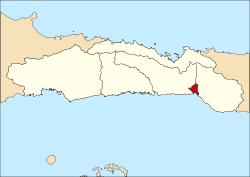
Location of City of Gorontalo in Gorontalo Province, Indonesia
Lambang Gorontalo. Berupa perisai bentuk jantung berwarna ungu dengan padi berjumlah 42 bulir dan kapas 19 kuntum, bintang, rantai berjumlah 23 cincin serta pita bertuliskan Provinsi Gorontalo. Bagian dalam berbentuk bulat telur maleo, dengan sayap maleo kembar berjumlah 8+8=16, dua pohon kelapa, benteng, dan sebuah buku terbuka. Rantai 23 cincin yang menyatukan padi dan kapas melambangkan 23 Januari, sedangkan kapas 19 kuntum + padi 42 bulir melambangkan 1942 (23 Januari 1942 adalah peringatan merdekanya Gorontalo dari belenggu penjajahan Belanda), sedangkan sayap maleo 8+8 helai melambangkan hari pembentukan Provinsi Gorontalo pada 16 Februari 2000. Lambang ini diciptakan oleh Roni Katili.
Autor/Urheber: Gorontalo City, Lizenz: CC BY-SA 4.0
Flag of Gorontalo City, based on this image
Autor/Urheber: Uwe Dedering, Lizenz: CC BY-SA 3.0
Location map of Indonesia.
Equirectangular projection. Stretched by 100.0%. Geographic limits of the map:
- N: 6.5° N
- S: -11.5° N
- W: 94.5° E
- E: 141.5° E


