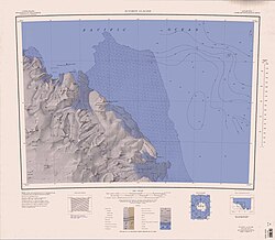
Goodman Hills
| Goodman Hills | ||
|---|---|---|
 Goodman Hills (links oben) | ||
| Lage | Viktorialand, Ostantarktika | |
| Teil der | Wilson Hills im Transantarktischen Gebirge | |
| Koordinaten | 69° 27′ S, 158° 43′ O | |
Die Goodman Hills sind eine Gruppe von Hügeln an der Oates-Küste des ostantarktischen Viktorialands. Sie ragen über eine Länge von 15 km zwischen dem Paternostro-Gletscher und dem Tomilin-Gletscher südlich des Kap Kinsey auf.
Das Gebiet wurde durch Vermessungen des United States Geological Survey und mithilfe von Luftaufnahmen der United States Navy zwischen 1960 und 1963 kartografisch erfasst. Benannt sind die Hügel nach Kelsey B. Goodman, Planungsoffizier im Kommandostab der Unterstützungsverbände der US-Navy in Antarktika zwischen 1969 und 1972, Mitarbeiter in der Abteilung für Polarregionen des US-Verteidigungsministeriums von 1972 bis 1974 sowie Mitglied des Advisory Committee on Antarctic Names und des United States Board on Geographic Names von 1973 bis 1976.
Weblinks
- Goodman Hills. In: Geographic Names Information System. United States Geological Survey, United States Department of the Interior, archiviert vom (englisch).
- Goodman Hills auf geographic.org (englisch)
Auf dieser Seite verwendete Medien
1:250,000-scale topographic reconnaissance map of the Suvorov Glacier area from 158°-162°E to 69°-70°S in Antarctica. Mapped, edited and published by the U.S. Geological Survey in cooperation with the National Science Foundation.
Autor/Urheber: Alexrk2, Lizenz: CC BY-SA 3.0
Physische Positionskarte Antarktis, Mittabstandstreue Azimutalprojektion


