Golden Bay / Mohua
| Golden Bay / Mohua | |
|---|---|
 Die Golden Bay / Mohua mit der nördlich angrenzenden Landzunge Farewell Spit | |
| Gewässer | |
| Geographische Lage | 41° S, 173° O |
 | |
| Breite | 35 km |
| Tiefe | 29 km |
| Fläche | 812 km² |
| Küstenlänge | 85 km |
Die Golden Bay / Mohua ist eine Bucht am Nordende der Südinsel von Neuseeland.
Geographie
Die Golden Bay / Mohua befindet sich westlich des Übergangs von der Tasmansee zur Cook Strait. Die Bucht erstreckt sich bei einer Buchttiefe von rund 29 km und einer Breite von 35 km in Nord-Süd-Richtung über eine Fläche von rund 812 km². Die nördliche Begrenzung stellt die langgestreckte Nehrung Farewell Spit dar, nahe dessen östlichem Ende der Leuchtturm Farewell Spit Lighthouse steht. Im Süden bildet der Separation Point im Abel Tasman National Park die Grenze zur größeren Nachbarbucht, der Tasman Bay / Te Tai-o-Aorere.[1][2]
Der Nordteil der Bucht ist kaum bevölkert und im Süden liegt die kleine, dicht besiedelte Ebene um die Mündung des Tākaka River. Dazwischen befindet sich die kleine Stadt Collingwood. Den zweiten wichtigen Zufluss zur Bucht stellt der Aorere River dar.[1]
Geschichte
Der niederländische Entdecker Abel Tasman ankerte 1642 in der Golden Bay / Mohua, nachdem er Neuseeland einige Tage zuvor als erster Europäer gesichtet hatte.
Mit denen sich dem Schiff von Tasman in einem Waka (Kanu) nähernden Māori konnte man seinerzeit nicht kommunizieren. Nachdem die Māori ein Beiboot des Schiffes angegriffen und vier Besatzungsmitglieder getötet hatten und sich Māori in größerer Zahl am Ufer, möglicherweise zu einem Angriff, sammelten, verließ Tasman die Bucht und verlieh ihr den Namen Mordenaers Bay („Mörderbucht“). Der englischen Entdecker und Seefahrer Kapitän James Cook schloss sie 1770 als Teil der Blind Bay mit ein. 1835 bekam die Bucht von dem französischen Seefahrer und Kapitän Jules Dumont d’Urville den Namen Massacre Bay verliehen und schon sieben Jahre später führte die Entdeckung von Kohle in Takaka 1842 zu der Änderung in Coal Bay.[3]
1857 entdeckten Jäger am Aorere River zufällig Gold, was der Bucht zum dem noch heutigen Namen Golden Bay verhalf. Für die Māori hingegen hatte die Bucht wegen des Mohua, einem Gelbköpfchen genannten Vogels, eine besondere Bedeutung, weswegen sie die Bucht Mohua nannten. Dem wurde durch die Umbenennung der Bucht in Golden Bay / Mohua im Jahr 2014 Rechnung getragen.[3]
An die Entdeckung Neuseelands und den ersten Kontakt zwischen Māori und Europäern am 18. Dezember 1642 erinnert das Abel Tasman Monument bei Tarakohe.
Fotogalerie
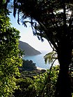
Strand an der Golden Bay / Mohua im Abel Tasman National Park

Abel Tasman in der Bucht (18. Dezember 1642)

Das Abel Tasman Monument bei Tarakohe
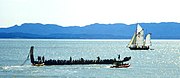
Waka (Kanu) in der Golden Bay / Mohua
Weblinks
- Golden Bay / Mohua. In: New Zealand Gazetteer. Land Information New Zealand, abgerufen am 17. April 2022 (englisch).
Einzelnachweise
- ↑ a b Golden Bay, Tasman. In: NZ_Topo_MAP. Gavin Harriss, abgerufen am 17. April 2022 (englisch).
- ↑ Koordinaten und Längenbestimmungen wurden mittels Google Earth Pro Version 7.3.4.8248 am 17. April 2022 vorgenommen
- ↑ a b Golden Bay / Mohua. In: New Zealand Gazetteer. Land Information New Zealand, abgerufen am 17. April 2022 (englisch).
Auf dieser Seite verwendete Medien

A view of the Murderers' Bay, as you are at anchor here in 15 fathom (text upper left). A drawing with description made by Abel Tasman's artist Isaack Gilsemans on the occasion of a skirmish between the Dutch explorers and Māori people at what is now called Golden Bay, New Zealand. This drawing is the first European impression of Māori people. Translation of the index on the right:
A. are our ships (on the left the 'Zeehaen', on the right the 'Heemskerck').
B. are the pirogues that came around our ships.
C. is the pirogue of the Zeehaen, which was taken by the inhabitants of these lands while paddling towards our ship (the Heemskerck) and subsequently left again (by the Māori) after gunfire. Our skipper was picked up with our sloop, after we saw that they had left the pirogue.
D. is the appearance of her pirogues and the appearance of the people.
E. are our ships going under sail.
Location map of Golden Bay, New Zealand
.jpg)
Autor/Urheber: Genet (Diskussion), Lizenz: CC BY-SA 4.0
NZ_-_Abel_Tasman_Monument_(Monolith)
Farewell Spit in New Zealand. - This is a composite Landsat false-colour satellite montage made with NASA World Wind.

Photo taken by Patrick Orlob, September 2005. One of many beaches along Golden Bay in Abel Tasman National Park on New Zealand's South Island.
.jpg)
Autor/Urheber: Archives New Zealand from New Zealand, Lizenz: CC BY 2.0
Abel Tasman was one of several European explorers in search of a legendary “great southern land”, and in December 1642 he became the first European to officially view Aotearoa. Tasman had first sighted the coast on 13 December. His flagship, the yacht Heemskerck, and an armed transport ship, the Zeehaen, sailed up the West Coast, reaching Cape Farewell on the 16th. On the 18th they anchored in Wharawharangi Bay, off the Tata Islands to the north of what is now Abel Tasman National Park.
The local inhabitants were Māori of Ngāti Tūmatakōkiri, although other iwi may have been visiting or raiding the area. Two waka paddled out to inspect the ships more closely. The Māori challenged the intruders with ritual incantations and pūkāea or pūtātara (trumpet) blasts; in response the Dutch, shouted and blew their own trumpets. They then decided to fire a cannon, which according to an account from the Dutch ship’s barber-surgeon provoked an angry reaction.
On 19 December a number of waka came out to the Dutch ships. The Heemskerck’s small boat was sent to the Zeehaen to warn the crew to be on their guard and not to let too many on board. While returning to the Heemskerck, the boat was rammed by a waka and the sailors were attacked with paddles and ‘long staffs’. Three were killed and one mortally wounded. One of the dead was taken by the attackers, and the waka sped back to shore out of range of the muskets and cannon which opened fire from both ships.
As the Dutch ships weighed anchor and set sail, 11 waka approached and were fired on. The leading boat was struck by canister shot which may have wounded one of its occupants. Tasman named the place Moordenaers’ (Murderers’) Bay. It is now called Golden Bay.
On 19 March 1992, Queen Beatrix of the Netherlands visited Golden Bay as part of the 350th anniversary of Abel Tasman’s visit to New Zealand. Shown here is part of the ceremony featuring a large Māori waka – other events including a pōwhiri and unveiling of monuments in Golden Bay.
Archives Reference: ABNP W4247 Box 5/ 4E <a href="https://archway.archives.govt.nz/ViewFullItem.do?code=18379253" rel="nofollow">archway.archives.govt.nz/ViewFullItem.do?code=18379253</a>
For updates on our On This Day series and news from Archives New Zealand, follow us on Twitter: <a href="https://www.twitter.com/ArchivesNZ" rel="nofollow">www.twitter.com/ArchivesNZ</a>
Material from Archives New Zealand
Caption information from <a href="http://www.nzhistory.net.nz/page/first-contact-between-maori-and-europeans" rel="nofollow">www.nzhistory.net.nz/page/first-contact-between-maori-and...</a>