Goffstown
| Goffstown | ||
|---|---|---|
 | ||
| Lage in New Hampshire | ||
| Basisdaten | ||
| Gründung: | 1761 | |
| Staat: | Vereinigte Staaten | |
| Bundesstaat: | New Hampshire | |
| County: | Hillsborough County | |
| Koordinaten: | 43° 1′ N, 71° 36′ W | |
| Zeitzone: | Eastern (UTC−5/−4) | |
| Einwohner: | 18.577 (Stand: 2020) | |
| Haushalte: | 6.289 (Stand: 2020) | |
| Fläche: | 97,2 km2 (ca. 38 mi²) davon 95,5 km2 (ca. 37 mi²) Land | |
| Bevölkerungsdichte: | 195 Einwohner je km2 | |
| Höhe: | 94 m | |
| Postleitzahl: | 03045 | |
| Vorwahl: | +1 603 | |
| FIPS: | 33-29860 | |
| GNIS-ID: | 0873606 | |
| Website: | goffstownnh.gov | |
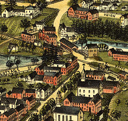
 Goffstown im Jahr 1887 | ||
Goffstown ist eine Town im östlichen Teil des Hillsborough County in New Hampshire, USA und liegt westlich von Manchester. Beim United States Census 2020 hatte Goffstown 18.577 Einwohner.[1] In der Town liegen die Siedlungen Grasmere und Pinardville.
Goffstown ist Sitz der katholischen Privatuniversität Saint Anselm College sowie der Benediktinerabtei Saint Anselm Abbey und zudem des New Hampshire State Prison für Frauen.
Persönlichkeiten
Der Unternehmer und Politiker Mark Warden lebt in der Stadt. Von 1802 bis 1811 war der spätere US-Senator David L. Morril Pfarrer in Goffstown. Zum Abt der Benediktinerabtei St. Anselm wurde 2024 Isaac Murphy OSB gewählt, der der erste Nichtpriester einer Benediktinerabtei der Neuzeit ist, der zum Abt gewählt wurde.
Weblinks
Einzelnachweise
- ↑ Decennial Census 2020. US Census Bureau, abgerufen am 3. Oktober 2021.
Auf dieser Seite verwendete Medien
Autor/Urheber: Alexrk2, Lizenz: CC BY 3.0
Positionskarte von New Hampshire, USA
Piscataquog River & Goffstown, NH; from an 1887 panoramic map by George E Norris.
Autor/Urheber: Struthious Bandersnatch, Lizenz: CC BY-SA 3.0
Exterior of the Goffstown Town Hall in Goffstown, New Hampshire.
This is a locator map showing Hillsborough County in New Hampshire. For more information, see Commons:United States county locator maps.


