Gladstone Region
| Gladstone Region | |
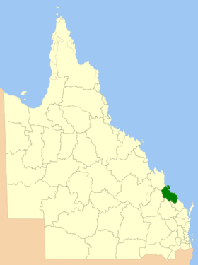
 Lage der Gladstone Region in Queensland | |
| Gliederung | |
| Staat: | |
| Bundesstaat: | |
| Verwaltungssitz: | Gladstone |
| Daten und Zahlen | |
| Fläche: | 10.484,3 km² |
| Einwohner: | 61.640 (2016) [1] |
| Bevölkerungsdichte: | 5,9 Einwohner je km² |
Koordinaten: 23° 51′ S, 151° 15′ O Die Gladstone Region ist ein lokales Verwaltungsgebiet (LGA) im australischen Bundesstaat Queensland. Das Gebiet ist 10.484 km² groß und hat etwa 62.000 Einwohner.[1]
Geografie
Die Region liegt an der Ostküste des Staats etwa 440 km nördlich der Hauptstadt Brisbane.
Größte Stadt und Verwaltungssitz der LGA ist Gladstone mit etwa 33.400 Einwohnern.[2] Zur Region gehören folgende Stadtteile und Ortschaften: Agnes Water, Aldoga, Ambrose, Baffle Creek, Barney Point, Beecher, Benaraby, Berajondo, Bororen, Boyne Island, Boyne Valley, Boynedale, Bracewell, Burua, Byellee, Callemondah, Calliope, Captain Creek, Clinton, Colosseum, Coral Sea, Curtis Island, Darts Creek, Deepwater, Diglum, East End, Euleilah, Eurimbula, Foreshores, Gindoran, Gladstone Central, Gladstone Harbour, Glen Eden, Iveragh, Kin Kora, Kirkwood, Lowmead, Machine Creek, Miriam Vale, Mount Alma, Mount Larcom, Mount Maria, Mount Tom, New Auckland, Oconnell, Oyster Creek, Raglan, River Ranch, Rodds Bay, Rosedale, Round Hill, Rules Beach, Seventeen Seventy, South Gladstone, South Trees, Sun Valley, Tablelands, Tannum Sands, Taragoola, Targinie, Taunton, Telina, The Narrows, Toolooa, Turkey Beach, West Gladstone, West Stowe, Wooderson, Wurdong Heights und Yarwun. Auch Heron Island gehört zur Gladstone Region.
Geschichte
Die heutige Gladstone Region entstand 2008 aus der City of Gladstone und den beiden Shires Callipe und Miriam Vale.
Verwaltung
Der Gladstone Regional Council hat neun Mitglieder. Der Mayor (Bürgermeister) und acht weitere Councillor werden von allen Bewohnern der Region gewählt. Die LGA ist nicht in Wahlbezirke unterteilt.
Weblinks
- Offizielle Seite des Gladstone Regional Council (englisch)
- Queensland Places: Gladstone Regional Council (englisch)
Einzelnachweise
- ↑ a b Gladstone (R). 2016 Census Quickstat. Australian Bureau of Statistics, 27. Juni 2017, abgerufen am 14. Mai 2020 (englisch).
- ↑ Gladstone. 2016 Census Quickstat. Australian Bureau of Statistics, 27. Juni 2017, abgerufen am 14. Mai 2020 (englisch).
Auf dieser Seite verwendete Medien
Flag of Australia, when congruence with this colour chart is required (i.e. when a "less bright" version is needed).
See Flag of Australia.svg for main file information.State flag and government ensign (internal waters only) of Queensland.
FIAV 110010.svg:
Autor/Urheber: self, Lizenz: CC BY-SA 3.0
Location of the Local Government Area in Queensland


