Gipsy Hill
| Gipsy Hill | ||
|---|---|---|
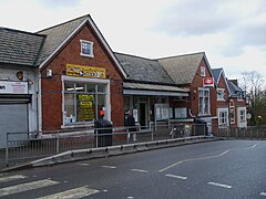
| Gipsy Hill Bahnhof (vor 2009) | ||
| Koordinaten | 51° 25′ N, 0° 5′ W | |
| OS National Grid | TQ332710 | |
| ||
| Traditionelle Grafschaft | Surrey | |
| Verwaltung | ||
| Post town | LONDON | |
| Postleitzahlenabschnitt | SE19, SE27 | |
| Vorwahl | 020 | |
| Landesteil | England | |
| Region | Greater London | |
| London Borough | Lambeth | |
| Britisches Parlament | Dulwich und West Norwood | |
Gipsy Hill ist ein Stadtteil der London Borough of Lambeth im Süden Londons. Er hat einen Bahnhof, die Gipsy Hill railway station.[1] Zu den historischen Gebäuden zählt der viktorianische Turm der Christ Church.
Weblinks
Anmerkungen
- ↑ siehe auch englische Wikipedia
Auf dieser Seite verwendete Medien
Autor/Urheber: Sunil060902, Lizenz: CC BY-SA 3.0
Gipsy Hill station building
Autor/Urheber: Brixtonhill, Lizenz: CC BY-SA 4.0
Upper stages of the tower of the former Christ Church parish church, Highland Road, Gipsy Hill, London SE19
Contains Ordnance Survey data © Crown copyright and database right, CC BY-SA 3.0
Map of Greater London, UK with the following information shown:
- Administrative borders
- Coastline, lakes and rivers
- Roads and railways
- Urban areas
Equirectangular map projection on WGS 84 datum, with N/S stretched 160%
Geographic limits:
- West: 0.57W
- East: 0.37E
- North: 51.72N
- South: 51.25N


