Gièvres
| Gièvres | ||
|---|---|---|
 |
| |
| Staat | Frankreich | |
| Region | Centre-Val de Loire | |
| Département (Nr.) | Loir-et-Cher (41) | |
| Arrondissement | Romorantin-Lanthenay | |
| Kanton | Selles-sur-Cher | |
| Gemeindeverband | Romorantinais et du Monestois | |
| Koordinaten | 47° 17′ N, 1° 40′ O | |
| Höhe | 72–102 m | |
| Fläche | 38,05 km² | |
| Einwohner | 2.367 (1. Januar 2020) | |
| Bevölkerungsdichte | 62 Einw./km² | |
| Postleitzahl | 41130 | |
| INSEE-Code | 41097 | |
| Website | https://www.gievres.fr/ | |
© Croquant / Wikimedia Commons, CC BY-SA 3.0 Empfangsgebäude des Bahnhofs Gièvres | ||
Gièvres ist eine Gemeinde mit 2367 Einwohnern (Stand: 1. Januar 2020) im französischen Département Loir-et-Cher der Region Centre-Val de Loire. Die Gemeinde gehört zum Arrondissement Romorantin-Lanthenay und zum Kanton Selles-sur-Cher. Die Einwohner werden Gièvrois(es) genannt.
Geographie
Gièvres liegt etwa zehn Kilometer südwestlich von Romorantin-Lanthenay am Canal de Berry zwischen Cher und Sauldre. Umgeben wird Gièvres von den Nachbargemeinden Pruniers-en-Sologne im Norden, Villefranche-sur-Cher im Osten, La Chapelle-Montmartin im Südosten, Chabris im Süden sowie Selles-sur-Cher im Westen.
Bevölkerungsentwicklung
| 1962 | 1968 | 1975 | 1982 | 1990 | 1999 | 2006 | 2018 |
|---|---|---|---|---|---|---|---|
| 1292 | 1254 | 1534 | 1666 | 1767 | 1999 | 2185 | 2386 |
Sehenswürdigkeiten

Weblinks
Auf dieser Seite verwendete Medien
(c) Karte: NordNordWest, Lizenz: Creative Commons by-sa-3.0 de
Positionskarte von Frankreich mit Regionen und Départements
Autor/Urheber: Celbusro, Lizenz: CC BY-SA 3.0
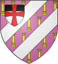
Blason français de la ville de Gièvres (Loir-et-Cher) : De pourpre semé de colonnes antiques d'or, aux deux barres d'argent ; à l'écusson, brochant en chef à dextre sur le tout, d'argent au chef de sable, à la croix latine pattée de gueules, brochante.
© Croquant / Wikimedia Commons, CC BY-SA 3.0
Gare de Gièvres, Loir-et-Cher, France
Autor/Urheber: Roehrensee in der Wikipedia auf Deutsch, Lizenz: CC BY-SA 3.0
Gare de Gièvres


