George-VI-Schelfeis
Koordinaten: 71° 45′ S, 68° 0′ W
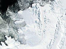
Das George-VI-Schelfeis ist ein 23.880 km² großes Schelfeis, das den größten Teil des George-VI-Sund zwischen der Alexander-I.-Insel und dem Palmerland ausfüllt. Es erstreckt sich vom Ronne Entrance am südwestlichen Ende des Sunds bis zur Niznik-Insel etwa 48 km südlich der nördlichen Einfahrt zwischen Kap Brown und Kap Jeremy.
Das UK Antarctic Place-Names Committee benannte es 1974 in Anlehnung an die Benennung des gleichnamigen Sunds nach dem britischen Monarchen Georg VI. (1895–1952).
Weblinks
- George VI Ice Shelf auf geographic.org
- George VI Ice Shelf im Geographic Names Information System des United States Geological Survey
Auf dieser Seite verwendete Medien
Autor/Urheber: Alexrk2, Lizenz: CC BY-SA 3.0
Physische Positionskarte Antarktis, Mittabstandstreue Azimutalprojektion
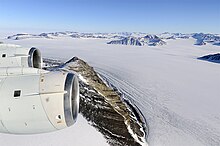
The DC-8 flew over Alexander Island on Mon., Oct. 24, 2011. Alexander Island is one of the largest islands off Antarctica. The George VI ice shelf connects the island to the Antarctic Peninsula; until the 1940s explorers thought it was part of the mainland. Credit: Michael Studinger/NASA


