Gauley Bridge
| Gauley Bridge | ||
|---|---|---|
 Blick auf Gauley Bridge | ||
| Lage in West Virginia | ||
| Basisdaten | ||
| Staat: | Vereinigte Staaten | |
| Bundesstaat: | West Virginia | |
| County: | Fayette County (West Virginia) | |
| Koordinaten: | 38° 10′ N, 81° 12′ W | |
| Zeitzone: | Eastern (UTC−5/−4) | |
| Einwohner: | 553 (Stand: 2020) | |
| Haushalte: | 275 (Stand: 2020) | |
| Höhe: | 249 m | |
| Vorwahl: | +1 304 | |
| FIPS: | 54-30364 | |
| GNIS-ID: | 2390902 | |
| Website: | local.wv.gov/GauleyBridge | |
| Bürgermeister: | Robert (Bob) Scott | |
Gauley Bridge ist eine Town im Fayette County im US-Bundesstaat West Virginia. Die Siedlung wurde auch Kincaids Ferry genannt.[1]
Lage
Die Stadt liegt am Kanawha River, der hier durch den Zusammenfluss des New Rivers und des Gauley Rivers entsteht.
Weblinks
Einzelnachweise
Auf dieser Seite verwendete Medien
Looking across the Gauley River at the town of Gauley Bridge. The pilings in the foreground are the remains of the Civil War-era covered bridge that gave the town its name. The original bridge was destroyed by retreating Confederate troops in 1861.
Photo taken with a Panasonic Lumix DMC-FZ50 in Fayette County, WV, USA.
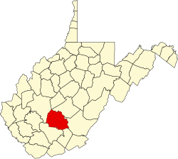
This is a locator map showing Fayette County in West Virginia. For more information, see Commons:United States county locator maps.
Autor/Urheber: Alexrk2, Lizenz: CC BY 3.0
Positionskarte von West Virginia, USA
Quadratische Plattkarte, N-S-Streckung 130.0 %. Geographische Begrenzung der Karte:
- N: 40.8° N
- S: 37.0° N
- W: 82.8° W
- O: 77.5° W


