Gabriac (Lozère)
| Gabriac | ||
|---|---|---|
| ||
| Region | Okzitanien | |
| Département (Nr.) | Lozère (48) | |
| Arrondissement | Florac | |
| Kanton | Le Collet-de-Dèze | |
| Gemeindeverband | Cévennes au Mont Lozère | |
| Koordinaten | 44° 11′ N, 3° 43′ O | |
| Höhe | 353–864 m | |
| Fläche | 8,41 km² | |
| Einwohner | 100 (1. Januar 2018) | |
| Bevölkerungsdichte | 12 Einw./km² | |
| Postleitzahl | 48110 | |
| INSEE-Code | 48067 | |
Gabriac ist eine französische Gemeinde mit 100 Einwohnern (Stand: 1. Januar 2018) im Département Lozère in der Region Okzitanien (vor 2016 Languedoc-Roussillon). Sie gehört zum Arrondissement Florac und zum Kanton Le Collet-de-Dèze. Sie grenzt im Nordwesten an Le Pompidou, im Norden an Molezon, im Osten an Sainte-Croix-Vallée-Française und im Süden und im Südwesten an Saint-André-de-Valborgne.
Bevölkerungsentwicklung
| Jahr | 1962 | 1968 | 1975 | 1982 | 1990 | 1999 | 2008 | 2018 |
|---|---|---|---|---|---|---|---|---|
| Einwohner | 120 | 107 | 102 | 107 | 102 | 97 | 107 | 100 |
Sehenswürdigkeiten
- Burgruine
- ehemalige protestantische Kirche aus dem 19. Jahrhundert

Burgruine
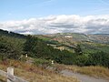
Blick in das Vallée française
Weblinks
Commons: Gabriac – Sammlung von Bildern, Videos und Audiodateien
Auf dieser Seite verwendete Medien

France adm-2 location map.svg
(c) Karte: NordNordWest, Lizenz: Creative Commons by-sa-3.0 de
Positionskarte von Frankreich mit Regionen und Départements
(c) Karte: NordNordWest, Lizenz: Creative Commons by-sa-3.0 de
Positionskarte von Frankreich mit Regionen und Départements

FR-48-Corniche des Cévennes03.JPG
Autor/Urheber: Szeder László, Lizenz: CC BY-SA 4.0
Autor/Urheber: Szeder László, Lizenz: CC BY-SA 4.0
- Corniche des Cévennes - ruines of abondoned building near Gabriac crossing

Commune de Gabriac, Lozère-la vallée française- 01.JPG
Autor/Urheber: Basicdesign, Lizenz: CC BY-SA 3.0
West-North-West view of the commune (borough) of Gabriac, Lozère département, région Languedoc-Roussillon, France. View of the Vallée Française from the road called Corniche des Cévennes which makes the border between the Lozère and Gard departements; it runs from Saint-Romain-de-Tousque to Le Pompidou (and further, from Saint-Jean-du-Gard and Saint-Laurent-de-Trèves / Florac). The piece of road seen immediately beneath us is the parking by-way for the observation site (it does not lead anywhere). The village of La Falguière is very slightly to the left of the middle point of the horizon line.