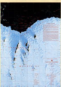
Framnes Mountains
| Framnes Mountains | ||
|---|---|---|
(c) Brolsma, H. (1999, updated 2014) Framnes Mountains Satellite Image Map 1:100000 Australian Antarctic Data Centre - CAASM Metadata (https://data.aad.gov.au/metadata/records/framnes_sat), CC BY 3.0 Satellitenaufnahme der Framnes Mountains | ||
| Lage | Mac-Robertson-Land, Ostantarktika | |
| Koordinaten | 67° 51′ S, 62° 41′ O | |
Die Framnes Mountains sind ein bis zu 1490,9 m[1] hohes Gebirge im ostantarktischen Mac-Robertson-Land, das im Wesentlichen aus der Casey Range, der Masson Range und der David Range sowie angrenzenden Gipfeln und Bergen besteht.
Entdeckt wurden sie bei der British Australian and New Zealand Antarctic Research Expedition (1929–1931) unter der Leitung des australischen Polarforschers Douglas Mawson. Im gleichen Zeitraum sichteten auch norwegische Walfänger das Gebirge. Das gesamte Gebiet wurde von norwegischen Kartografen anhand von Luftaufnahmen kartiert, die bei der Lars-Christensen-Expedition 1936/37 entstanden. Christensen benannte das Gebirge Framnesfjella nach einem Hügel in der Nähe des südnorwegischen Sandefjord. Das Advisory Committee on Antarctic Names übertrug 1947 den Namen ins Englische.
Weblinks
- Framnes Mountains. In: Geographic Names Information System. United States Geological Survey, United States Department of the Interior, archiviert vom (englisch).
- Framnes Mountains auf geographic.org (englisch)
Einzelnachweise
- ↑ Framnes Mountains im Composite Gazetteer of Antarctica, abgerufen am 24. April 2021 (englisch).
Auf dieser Seite verwendete Medien
(c) Brolsma, H. (1999, updated 2014) Framnes Mountains Satellite Image Map 1:100000 Australian Antarctic Data Centre - CAASM Metadata (https://data.aad.gov.au/metadata/records/framnes_sat), CC BY 3.0
Satellite image map of Framnes Mountains, Mac. Robertson Land, Antarctica. This map was produced for the Australian Antarctic Division by AUSLIG (now Geoscience Australia) Commercial, in Australia, in 1997. The map is at a scale of 1:100000, and was produced from SPOT XS (WRS 246-491, 246-490) and Landsat TM (WRS 137-107, 135-108) scenes. It is projected on a Transverse Mercator projection, and shows glaciers/ice shelves, stations/bases, refuges/depots, specially protected areas (SPA), and gives some historical text information. The map has both geographical and UTM co-ordinates.
Autor/Urheber: Alexrk2, Lizenz: CC BY-SA 3.0
Physische Positionskarte Antarktis, Mittabstandstreue Azimutalprojektion


