Fillmore County (Nebraska)
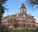
![Fillmore County Courthouse, gelistet im NRHP Nr. 78001698[1]](http://upload.wikimedia.org/wikipedia/commons/thumb/d/d2/Fillmore_County_Courthouse_%28Nebraska%29_5.jpg/298px-Fillmore_County_Courthouse_%28Nebraska%29_5.jpg) Fillmore County Courthouse, gelistet im NRHP Nr. 78001698[1] | |
| Verwaltung | |
|---|---|
| US-Bundesstaat: | Nebraska |
| Verwaltungssitz: | Geneva |
| Adresse des Verwaltungssitzes: | County Courthouse 900 G Street P.O. Box 307 Geneva, NE 68361-0307 |
| Gründung: | 1856 |
| Vorwahl: | 001 402 |
| Demographie | |
| Einwohner: | 5.551 (Stand: 2020) |
| Bevölkerungsdichte: | 3,72 Einwohner/km2 |
| Geographie | |
| Fläche gesamt: | 1493 km² |
| Wasserfläche: | 0 km² |
| Karte | |
| Website: www.fillmorecounty.org | |
Fillmore County[2] ist ein County im Bundesstaat Nebraska der Vereinigten Staaten. Verwaltungssitz (County Seat) ist Geneva.
Geographie
Das County liegt im Südosten von Nebraska, ist im Süden etwa 40 km von Kansas entfernt und hat eine Fläche von 1493 Quadratkilometern ohne nennenswerte Wasserfläche. An das Fillmore County grenzen folgende Countys:
| York County | Seward County | |
| Clay County |  | Saline County |
| Nuckolls County | Thayer County | Jefferson County |
Geschichte
Fillmore County wurde 1856 gebildet. Benannt wurde es nach dem Präsidenten Millard Fillmore.
18 Bauwerke und Stätten des Countys sind insgesamt im National Register of Historic Places eingetragen (Stand 11. Februar 2018).[3]
Demografische Daten
| Bevölkerungswachstum | |||
|---|---|---|---|
| Census | Einwohner | ± rel. | |
| 1870 | 238 | — | |
| 1880 | 10.204 | 4.187,4 % | |
| 1890 | 16.022 | 57 % | |
| 1900 | 15.087 | −5,8 % | |
| 1910 | 14.674 | −2,7 % | |
| 1920 | 13.671 | −6,8 % | |
| 1930 | 12.971 | −5,1 % | |
| 1940 | 11.417 | −12 % | |
| 1950 | 9.610 | −15,8 % | |
| 1960 | 9.425 | −1,9 % | |
| 1970 | 8.137 | −13,7 % | |
| 1980 | 7.920 | −2,7 % | |
| 1990 | 7.103 | −10,3 % | |
| 2000 | 6.634 | −6,6 % | |
| 2010 | 5.890 | −11,2 % | |
| 2020 | 5.551 | −5,8 % | |
| Vor 1900[4] 1900–1990[5] 2000 + 2010[6]  Alterspyramide des Fillmore Countys (Stand: 2000) | |||
Nach der Volkszählung im Jahr 2000 lebten im Fillmore County 6634 Menschen. Davon wohnten 264 Personen in Sammelunterkünften, die anderen Einwohner lebten in 2689 Haushalten und 1801 Familien. Die Bevölkerungsdichte betrug 4 Einwohner pro Quadratkilometer. Ethnisch betrachtet setzte sich die Bevölkerung zusammen aus 97,8 Prozent Weißen, 0,2 Prozent Afroamerikanern, 0,4 Prozent amerikanischen Ureinwohnern, 0,1 Prozent Asiaten und 0,8 Prozent aus anderen ethnischen Gruppen; 0,7 Prozent stammten von zwei oder mehr Ethnien ab. 1,7 Prozent der Bevölkerung waren spanischer oder lateinamerikanischer Abstammung.
Von den 2689 Haushalten hatten 30,2 Prozent Kinder und Jugendliche unter 18 Jahre, die bei ihnen lebten. 59,1 Prozent waren verheiratete, zusammenlebende Paare, 5,0 Prozent waren allein erziehende Mütter, 33,0 Prozent waren keine Familien, 30,2 Prozent waren Singlehaushalte und in 16,3 Prozent lebten Menschen im Alter von 65 Jahren oder darüber. Die Durchschnittshaushaltsgröße betrug 2,37 und die durchschnittliche Familiengröße lag bei 2,95 Personen.
Auf das gesamte County bezogen setzte sich die Bevölkerung zusammen aus 26,3 Prozent Einwohnern unter 18 Jahren, 5,1 Prozent zwischen 18 und 24 Jahren, 24,0 Prozent zwischen 25 und 44 Jahren, 23,3 Prozent zwischen 45 und 64 Jahren und 21,3 Prozent waren 65 Jahre alt oder darüber. Das Durchschnittsalter betrug 41 Jahre. Auf 100 weibliche Personen kamen 93,5 männliche Personen. Auf 100 Frauen im Alter von 18 Jahren oder darüber kamen statistisch 91,3 Männer.
Das jährliche Durchschnittseinkommen eines Haushalts betrug 35.162 USD, das Durchschnittseinkommen der Familien betrug 41.725 USD. Männer hatten ein Durchschnittseinkommen von 29.813 USD, Frauen 18.507 USD. Das Prokopfeinkommen betrug 17.465 USD. 4,8 Prozent der Familien und 7,8 Prozent der Bevölkerung lebten unterhalb der Armutsgrenze. Davon waren 8,2 Prozent Kinder oder Jugendliche unter 18 Jahre und 10,0 Prozent waren Menschen über 65 Jahre.[7]
Orte im County
- Bixby
- Burress
- Carlisle
- Exeter
- Fairmont
- Geneva
- Grafton
- Martland
- Milligan
- Ohiowa
- Shickley
- Strang
- Townhall
- Belle Prairie Township
- Bennett Township
- Bryant Township
- Chelsea Township
- Exeter-Fairmont Consolidated Township
- Franklin Township
- Geneva Township
- Glengary Township
- Grafton Township
- Hamilton Township
- Liberty Township
- Madison Township
- Momence Township
- Stanton Township
- West Blue Township
Siehe auch
Weblinks
Einzelnachweise
- ↑ Auszug aus dem National Register of Historic Places. Abgerufen am 13. März 2011
- ↑ GNIS-ID: 835851. Abgerufen am 22. Februar 2011 (englisch).
- ↑ Suchmaske Datenbank im National Register Information System. National Park Service, abgerufen am 11. Februar 2018.
- ↑ U.S. Census Bureau _ Census of Population and Housing. Abgerufen am 17. Februar 2011
- ↑ Auszug aus Census.gov. Abgerufen am 17. Februar 2011
- ↑ Auszug aus census.gov (2000+2010) (Seite nicht mehr abrufbar, festgestellt im Mai 2023. Suche in Webarchiven.) Archivierte Webseiten von WebCite sind nicht mehr abrufbar (siehe Disk) Abgerufen am 13. April 2012
- ↑ Fillmore County, Nebraska - Datenblatt mit den Ergebnissen der Volkszählung im Jahre 2000 bei factfinder.census.gov.
Koordinaten: 40° 31′ N, 97° 36′ W
Auf dieser Seite verwendete Medien
Cesko-narodni sin, aka Milligan Auditorium, in Milligan, Nebraska; seen from the front (east). The building was designed in Late Gothic Revival/Collegiate Gothic style by architects E.J. Kriz, R.O. Stake, and Karel Urban; the cornerstone was laid in 1929. The building is listed in the National Register of Historic Places.
Fillmore County Courthouse in Geneva, Nebraska, viewed from the southeast. The building was constructed in 1892; the architects, George E. McDonald and L.F. Pardue, designed it in Richardsonian Romanesque style. The building is listed in the National Register of Historic Places.
Deering Bridge, near Sutton, Nebraska; seen from the southeast (downstream). The bridge is located on the county line between Clay and Fillmore counties, where the county-line road crosses School Creek. The concrete spandrel arch bridge was built in 1916 by the Nebraska Bureau of Roads & Bridges and the Lincoln Construction Co. It is listed on the National Register of Historic Places.
Historic bridge in Fillmore County, Nebraska, seen from the west (upstream). The bridge is located where County Road 6 crosses the West Fork of the Big Blue River. The concrete spandrel arch bridge was designed by county engineer William A. Biba and built by contractor Frank N. Craven in 1918. It is listed in the National Register of Historic Places.
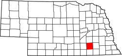
This is a locator map showing Fillmore County in Nebraska. For more information, see Commons:United States county locator maps.
Autor/Urheber:
- real name: Artur Jan Fijałkowski
- pl.wiki: WarX
- commons: WarX
- mail: [1]
- jabber: WarX@jabber.org
- irc: [2]
- software: own perl scripts
Age pyramid for Fillmore County, Nebraska, United States of America, based on census 2000 data


