Fergusson-Gletscher
| Fergusson-Gletscher | ||
|---|---|---|
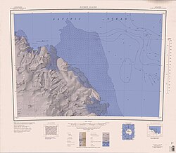
Fergusson-Gletscher (links der Kartenmitte) | ||
| Lage | Viktorialand, Ostantarktika | |
| Gebirge | Wilson Hills, Transantarktisches Gebirge | |
| Koordinaten | 69° 38′ S, 159° 10′ O | |
| Entwässerung | Noll-Gletscher | |
Der Fergusson-Gletscher ist ein Gletscher an der Oates-Küste des ostantarktischen Viktorialands. In den Wilson Hills fließt er in nordöstlicher Richtung zwischen dem Serba Peak und dem Feeney Ridge zum Noll-Gletscher.
Die Nordgruppe einer von 1963 bis 1964 dauernden Kampagne im Rahmen der New Zealand Geological Survey Antarctic Expedition nahm die Benennung vor. Namensgeber ist Bernard Fergusson, Baron Ballantrae (1911–1980), Generalgouverneur von Neuseeland von 1962 bis 1967.
Weblinks
- Fergusson Glacier. (ZIP; 1,76 MB) In: Geographic Names Information System. United States Geological Survey (englisch). (englisch)
- Fergusson Glacier auf geographic.org (englisch)
Auf dieser Seite verwendete Medien
Autor/Urheber: Alexrk2, Lizenz: CC BY-SA 3.0
Physische Positionskarte Antarktis, Mittabstandstreue Azimutalprojektion
1:250,000-scale topographic reconnaissance map of the Suvorov Glacier area from 158°-162°E to 69°-70°S in Antarctica. Mapped, edited and published by the U.S. Geological Survey in cooperation with the National Science Foundation.


