Fennoskandinavien


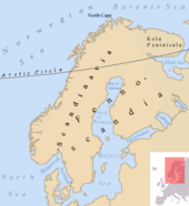
Fennoskandinavien, auch Fennoskandien oder Fennoskandia genannt, ist eine Bezeichnung für die nordeuropäische Halbinsel, die sich aus Finnland (Fenno-) und der Skandinavischen Halbinsel (-scandia) sowie Karelien und der Halbinsel Kola zusammensetzt. In regionalgeologischem Kontext wird dieses Gebiet, mit Ausnahme des nordwestlichen (kaledonischen) Teils des Skandinavischen Gebirges, als Fennoskandischer Schild oder auch Baltischer Schild bezeichnet.[1][2]
Der finnische Geologe Wilhelm Ramsay führte den Begriff 1898 ein (nach anderer Quelle erst 1900[2]) und begründete die Abgrenzung des Gebiets mit seiner geologisch-geographischen Einheit. Gemeint ist die Halbinsel, die durch Nord- und Ostsee sowie durch die Linie „Finnischer Meerbusen – Ladogasee – Onegasee – Weißes Meer“ (vgl. Weißmeer-Ostsee-Kanal) vom übrigen europäischen Festland abgegrenzt ist.
Literatur
- Hans Hausen: The History of Geology and Mineralogy in Finland 1828–1918. Helsinki 1968.
- Olaf Holtedahl: Geology of Norway. Oslo 1960.
- Hannes Saarinen: Von der russischen Grenzmark zum nordischen Staat. Zur Wahrnehmung Finnlands in der Zeit der Weimarer Republik. In: Jahrbücher für Geschichte Osteuropas, Neue Folge, Band 53, H. 3, Festschrift für Edgar Hösch (2005), S. 364–383 (JSTOR:41051448).
- Wilhelm Ramsay: Fennoskandias ålder. In: Fennia. 40. 1917, Nr. 4, S. 1–21.
Weblinks
Einzelnachweise
Auf dieser Seite verwendete Medien
Snow Cover Across Scandinavia. In this mostly cloud-free true-color scene, much of Scandinavia can be seen to be still covered by snow. From left to right across the top of this image are the countries of Norway, Sweden, Finland, and northwestern Russia. The Baltic Sea is located in the bottom center of this scene, with the Gulf of Bothnia to the north (in the center of this scene) and the Gulf of Finland to the northeast.

